| JOURNAL 2017 |
| North Craven Heritage Trust |
Introduction
Every year people from far and wide flock to Oxenber Wood in Spring to enjoy the display of wild flowers. Wood anemonies, primroses, early purple orchids and bluebells are among the many plant species which contribute to the fabulous scene in May. As a site of special scientific interests naturalists visit throughout the year in search of its rich flora, bird and insect life. So why is this place so special?Many people regard Oxenber simply as the massive dome of limestone, covering 89 ha, which sits between the settlements of Feizor, Wharfe and Austwick. Historically it was not one wood but four. Three are named after the settlement in closest proximity with Austwick wood also known as Oxenber. The fourth, Little Wood, was the site of a quarry and limekiln. These woods although similar also have their distinct features, due in part to their geology but also their farming history. In the following account I have used ‘Oxenber’ to include the whole area and not just the single wood.
Rather than having continuous tree cover the woods have areas of grassland with a scattering of trees which can be dense in places. As ‘wood pasture’ they provided shelter, grazing and fodder for livestock as well as wood and timber. Some of the trees may have been pollarded or cut back to a high stump out of reach of grazing animals. These trees would then have regenerated with multiple stems to provide wood or browsing for livestock in the winter. As a cross between woodland and grassland it provided both wood and grazing but had the disadvantage of not being as productive of wood, as for example coppice woodland, and not providing as good grazing as open pasture. Once a common feature of the landscape wood pastures are now comparatively rare.
Documentary Evidence
In order to understand why Oxenber has survived as a wood pasture it is useful to review the available documentary evidence as well as examining the physical evidence on the ground. As marginal land Oxenber was probably a wood pasture common, in that the people of Austwick, Feizor and Wharfe had rights to keep livestock and to cut wood but not timber, which was reserved for the landowner or lord of the manor. The Austwick Lordship Customes of 1573 stated that tenants had the right ‘of oake for building and repairing of fire houses and barnes when a need did require and also necessarie boughboote and ploughboote’ [1]. ‘Boughboote’ was the right to smaller branches of a tree, implying the end of the branch terminating in twigs and ‘ploughboote’ was timber or wood for the repair of ploughs and other farm tools [Wright, 1898].The earliest map showing Oxenber woods is that of Jeffreys’ survey of Yorkshire, published in 1771. Although drawn to a scale of one inch to the mile Oxenber is shown as a crescent of trees with little other detail. The first plan of interest was included in the Austwick Inclosure Award of 1814 [2]. Thomas Buttle, the commissioner, showed the boundaries of Oxenber. It also showed Little Wood with the quarry and another enclosed field called ‘Platt’. He made provision for a ‘private carriage and driving road called Lupton’s road leading out of ancient inclosures belonging to William Lupton in a northerly direction over Oxenber to a close called Platt belonging to the said William Lupton’. He also stated in the case of the quarry ‘an allotment or parcel of ground necessary to be set out upon the said commons & waste grounds for the digging and getting of stone and other materials for erecting and repairing of buildings, bridges, walls, fences and other works by the proprietors of estates within the township & manor of Austwick aforesaid & for the reparation of the highways and private roads within the same I do hereby allot & set apart a certain plot or parcel of ground lying on Oxenber as the same is now fenced out & inclosed containing in statute measure six acres two roods & thirteen perches. And I do hereby order & direct that the herbage & pasture of the said last mentioned allotment shall belong to & be from time to time considered as the sole & exclusive right & property of the several proprietors or persons having or being entitled to sheep gaits or other right or interest in or upon the said stinted pasture called Oxenber.’ He went onto allocate a total of 131 sheep gaits to 28 people: they ranged from a single gait for William Wilson to 18 for Charles Ingleby. The average was between four and five per person.
It is clear from the Award that it only applied to Oxenber and did not include either Wharfe or Feizor Woods. As there was no direction to enclose or fence the wood it can be concluded that a boundary wall already existed. By 1814 Little Wood and Platt were already enclosed and so these walls also pre-date the Award. It may seem strange that there was an Inclosure Award for land which was already enclosed. In effect Thomas Buttle was regulating the allocation of the grazing (stinting). Previously any one with common rights could have grazed as many animals without limit. So the Award was introduced to limit the over-exploitation of a common resource.
The Court Baron records for Austwick provide some further clues. The earliest reference to Oxenber dates from 1682 when orders were issued for the ‘fence lying betwixt Austwick Wood and daleland ... be made sufficient’. Platt first appeared in an entry for 1735 and was bought by Francis Lupton in 1769. The earliest record of beast or cattle gaits in Wharfe Wood dates from 1787. In other words it was stinted well before Oxenber. Unfortunately there appear to be no references to Feizor Wood in Lawkland manor records.
An undated document [3] contains a list of person with sheep gaits in Oxenber Wood. From details of the people listed it probably dates between 1837 and 1839, or just over a decade after the initial list in the Inclosure Award. By comparing the two lists it is evident that while some gaits had passed on through inheritance others had been sold. The later list was reduced to 20 people showing that there was a trend to consolidate holdings.
The most interesting document to have survived is the Austwick Stinted Pastures minute book [4]. The entries date from 1814 to 1991 and provide insights into the management of the pasture of which Oxenber was a part. The first meeting was held in April 1814 and it was agreed that the pastures should be cleared of all stock and that the animals would be re-admitted on 12th May until 13th February 1815. In subsequent years the grazing was limited to between April and the following February. The gait-holders also determined that every beast (cattle) should equate to four sheep gaits and every horse for eight sheep gaits. After midsummer six lambs equated to one beast gait. Finally James Wilcock was appointed ‘Hird’ with the duty ‘to go over all the pastures every day till old Michaelmas, to have three pence per sheep gait’. A year later, at the next meeting, a new Hird was appointed and his hours of work and pay were reduced. It was also agreed that ‘no sticks or hedging should be felled after the 26th of April in Oxenber’. In subsequent years more regulations and penalties were introduced. From 1816 all stock had to be marked before being put onto the pasture or else they would be removed to the pinfold. Then rams had to be removed by 1st September (1817). From 1821 all but the proprietors were forbidden to cut sticks or thorns. In 1825 ‘no person should be allowed to cut any wood or sticks in Oxenber either for sale or fire’. In 1826 the Hird was expected to repair the walls and part of his salary was withheld until the repairs were completed. Two years later there was a re-evaluation of sheep gaits so that a mare and foal equated to ten gaits and four lambs equalled a beast gait. Also no ewes with twin lambs were to be put on after midsummer. Then there were prohibitions about ‘sheep having the foot-rot, or any other infectious complaint’ and prosecution of trespassers. 1830 proved a bumper year: additional pay for the Hird for mole-catching, proprietors were at liberty to begin cutting hedging or pea sticks on 1st January, no person was allowed to get nuts in Oxenber before 25th September and the gate between the two woods to be locked after 13th November till 1st January. In 1832 a committee was formed ‘to set out roads and clear the land of wood where they think proper, also to drain and set wells, where wanted in Oxenber’. Perhaps this reflects a perception that the woodland was taking over and that the balance had to be redressed in favour of the grazing.
At the start of 20th century a separate committee was convened for Oxenber and entries appeared concerning drains, forming wells, clearing open spaces of briers and looking after the interests of the pasture generally. By 1909 manure was being applied to the pasture. In the 1950s bracken mowing had commenced and lime and slag was being spread on Oxenber. In 1962 one ton of ‘North African phosphates’ had been bought for £10 and 9 shillings to be shared between the two woods. In 1976 bracken was being controlled by spraying with herbicides. When the area was listed as a Site of Special Scientific Interest, the then Nature Conservancy Council became more closely involved with the management of the woodland.
A fragment of the ‘Austwick Wood or Oxenber’ account book for 1854 to 1860 has been preserved [5]. In 1857 a payment of £1 - 2s was received for stubbing of 16 ½ rods at 16d per rod. Stubbs were intermediate between coppice and pollards though the term was apparently also used for both [Rackham, 2003]. This single entry suggests that harvesting of the timber was not carried out on an annual basis and that the primary function of the wood pasture was grazing.
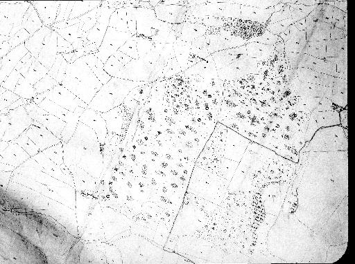
In 1847 a survey of Austwick and associated settlements was undertaken with a map drawn to the scale of three chains to the inch or 26.7 inches to the mile [6]. This was followed in 1851 with the completion of the schedule which listed the owners, tenants, areas of each field, often with their names as well as the use of the land. Each field was allocated a number which corresponded to those on the map. Figure 1 shows the map of Oxenber and four areas of woodland. The boundaries of Wharfe Wood appear unchanged when compared with a recent Ordnance Survey map. In the case of Oxenber, Little Wood or field 375 is clearly shown with its lime kiln. Similarly Platt or field 732 is shown as being enclosed with a track to it (as stipulated in the Inclosure Award of 1814). In the schedule it was described as meadow rather than pasture. Without contours being marked it is difficult to appreciate the steepness of the site! It would not have been an easy job to cut the hay by hand. Once again the boundaries of the wood match the current outline. However, there are two additional areas of woodland which have been added to Oxenber: fields 355 and 377. Both have since been cleared. Were these areas originally part of the wood pasture, which was then enclosed and felled, and subsequently re-planted only to be felled once again at some point after 1851? The situation for Feizor Wood is far more complex. It is clearly shown as a series of enclosed fields within the boundaries. On the eastern edge the map shows an area of plantation described as Nookdale wood and plantation. This was owned by Richard Clapham, who had recently inherited Austwick Hall and planted a wood behind the house [Culley and Pearson, 2014]. It is tempting to speculate that he had also planted the Feizor plantation. He also owned three of the eight fields marked on the map with another three people owning the rest. These fields were either described as wood or pasture.
The final piece of documentary evidence is a legal opinion provided by John Forbes [7]. In 1875 he was approached to untangle who had a right to what on Oxenber. In the introduction it was stated that a considerable extent of ground was covered with nut trees and brush wood and that in the last two years many people from outside the township were cutting pea sticks for sale. They were doing considerable damage and becoming a nuisance. So did the Lord of the Manor own the pea sticks, nuts and hedging? What were the rights of the gait owners, occupiers and other inhabitants of the township and who could take action against trespassers? John Forbes concluded that everything was the property of the lord of the manor and that only he could take legal action against persons damaging his property. However, some inhabitants of the township had acquired rights to take a reasonable quantity of pea sticks for their own use only and not for sale. These people had the right due to their ownership of property within the township and not simply because they occupied gaits on Oxenber. I cannot find any reference to this opinion being acted upon or of any prosecutions.
Boundary Survey
As already noted, the Inclosure Award of 1814 showed that the woodland was already enclosed by that date. This raises a number of questions: was the woodland more extensive at some point, which with clearance, was reduced to its present extent? And is it possible to date the construction of the current boundaries and what does this tell us about the history of the woodland pasture?Dating wall construction is problematic. Not only is there a lack of documentary evidence to indicate when the walls were built but where this exists there is always the uncertainty that the structure has been rebuilt or repaired. In the absence of any ‘absolute’ dating method archaeologists have used typological comparisons. The size of stones, whether they have been quarried or obtained by field clearance, as well as the dimensions of the walls, have all been used to classify dry stone walls. One of the most comprehensive of these studies was undertaken at Royston Grange in Derbyshire [Hodges, 1991]. Unfortunately subsequent surveys in Yorkshire have demonstrated that there are significant regional differences. There appears to be greater variety in wall construction than the Derbyshire study initially suggested.
In the Dales three surveys of walls have used a classification based on the presence of orthostats (large stones placed vertically), the profile of the structure, the presence of projecting top stones as well as the source of the stone [Beaumont, 2006; Johnson, 2013; Lord, 2004]. Not all these surveys provide all the wall dimensions, such as the width at the base of the wall, the width at its top, as well as the height. This lack of data makes comparisons difficult.
A survey was undertaken of all the walls within Oxenber, the present boundaries as well as further afield: to Far End House in the north, to Hale Lane in the south, Wood Lane in the west and Feizor Nick in the east. There was a preponderance of narrow top walls with just two sections of wide top walls (one of which had been identified by Tom Lord). There was also one possible wide top wall and two ruined walls. The two wide top walls lie on the eastern boundary of Feizor Wood (790684) and on the western boundary of Feizor and Oxenber Woods (784684).
Six sections of narrow top walls were measured: the height, the width at the top (below the cap stones) and the width at the base at ground level. Between three and five measurements were taken for each section depending on the ease of climbing the structure! Table 1 is a summary of the data. The results appear to be lower than data published for Enclosure Act walls apart from the top width. The base widths were in line with enclosure walls apart from the southern boundary of Wharfe Wood and the wall near Jop Riding. Initially there was some doubt as to whether the Jop Riding wall was a wide top one. It seems likely that the wall height had been reduced which would provide a wider width at the top. There were no signs of orthostats so it was concluded that this was a diminished narrow top wall. Combining the width at the top and base of the walls as a ratio all the sample showed higher values than those enclosure act walls for Grassington and Linton [Raistrick, 1969]. These data fit the documentary evidence. In other words the boundary walls existed before the Inclosure Act of 1814 and were different in dimensions to those walls specified in similar local acts.
Table 2 is a summary of the measurements for the two wide top walls at Oxenber, the two remnant walls with a comparison of a wide top wall below Robin Proctor’s scar. The width of the base of the ruined Platt wall was much narrower than the others and also narrower than the boundary walls. This may suggest that the Platt had been enclosed at a different time to the building of the woodland boundaries and possibly at a later date. The dimensions of the other walls appear reasonably consistent and the ratio of the top and base widths are higher than for the boundary walls. According to Tom Lord’s typology this would suggest that they predate the construction of the boundaries around the wood pasture. The other remnant wall which subdivides Oxenber is more difficult to categorise with just the base measurements available. In fact the bases of both wide and narrow top walls appear to average about three feet. The enclosure acts for Grassington and Linton both specified the same breadth at the base. Nevertheless the question of why Oxenber was subdivided remains.
Discussion
Is it possible to make sense of all this material and draw some conclusions about the development of Oxenber as a wood pasture? It is generally assumed that sometime in the past woodland was more common than it is now. The discovery of leg bones from the Eurasian lynx in local caves has provided evidence that woodland was more widespread than at present. Radiocarbon dating of a tibia from Moughton Fell cave provided a calibrated date of AD 80-320 whilst a femur from Kinsey cave provided a range of AD 25 to 600. As lynx rely on cover to hunt, these finds show that there there was woodland both during and after the Roman period (Hetherington et al., 2006). Some of the field and place names in and around Austwick are associated with trees, woodland or woodland clearings. For example, High and Low Birks (birch trees) are documented as early as 1595. Bark House (for tanning), Sowerthwaite (sour clearing), and Jop Ridding (rydding is a clearing) are other examples. Hollins (holly trees) and Eldroth (Alder Hill) refer to specific trees. Oxenber or Ox Hill, in Old English, suggests that this land use pre-dates the Norman conquest. It is tempting to speculate that once ploughing had finished the oxen were driven up to graze on Oxenber until they were needed again as draught animals. Other ox-related place names occur in neighbouring settlements: Ox Scar in Giggleswick and Oxgang Laithe in Langcliffe. According to ‘The dialect of Craven’ Plat(t) simply means place or situation [Carr, 1828].Unfortunately the entry for Austwick in the Domesday survey makes no reference to woodland. In fact none of the entries for the Dales provide any mention of woodland. The manor was clearly a valuable agricultural settlement which would have required draught animals for ploughing as well as pasture to feed them. The Survey provides assessments of the areas of woodland for other parts of Yorkshire. Although there was considerable variation in woodland cover the majority of the entries refer to ‘silua pastilis’ or woodland pasture with occasional mention of woodland without pasture, barren woodland and scrubland.
In fact there is no sharp distinction between wood pasture and other kinds of common land [Rackham, 2003]. On any common land the number of trees present will depend on the level of grazing and the extent of the management of the trees. Low levels of grazing will allow trees to re-colonise the area while high stocking will prevent any seedlings establishing themselves. Pollarding trees protects them from grazing animals as well as providing a crop of timber and wood. It also lengthens their lifespan. Ash trees have comparatively short lives. In a favourable environment they can live to about 200 years. If they are periodically cut down, either coppiced or pollarded, they can survive to 400 years or more [Rackham, 2015]. As the practice of pollarding has declined from the early nineteenth century [Rackham, 2003] few of the trees will have survived to the present.
An important feature of commons and wood pasture is that initially they were not enclosed. As pressure for land grew, possibly through population growth, more land was brought into cultivation. One solution was to encroach on commons and woodland. If the lord of the manor attempted to enclose a common this was generally resisted by those with rights to the land. This was the case in Austwick in 1510 when the Marquis of Dorset complained that a group of men had broken down the hedges and destroyed an enclosed pasture called Austwick waste. It was more acceptable and easier for others to enclose smaller areas and incorporate them into existing holdings. For the lord of the manor this unauthorised enclosure brought certain benefits in that the tenant now had to pay rent on this land. These are identified as ‘new rents’ in the Austwick Court Baron records and date from at least 1693. It is likely that Platt was one such encroachment. It also explains the Court Baron requirement for the repair of the boundary wall in 1682. If you look again at the outline boundaries of Oxenber, which are irregular in shape, it is possible that the walls were constructed to protect the newly enclosed land from animals straying from Oxenber. In other words the wood pasture was not enclosed but rather it was neighbouring land-holders who were walling off their encroachments which resulted in the current boundaries. These walls pre-date the award of 1814 and also the Court Baron record of 1682. Although the Stinted Minute book refers to the Hird being responsible for the maintenance of the walls is not clear whether this refers to the external boundaries or the internal walls which separated Oxenber from Wharfe and Feizor woods. These are where the oldest, possibly early medieval, walls were found.
Were these walls originally built as boundaries between the settlements of Austwick and Feizor to prevent animals straying on common land to neighbouring manors? The absence of such wide top walls between Wharfe and Oxenber woods may be explained by the fact that both settlements were part of the same manor and that land holders had rights over all the commons. At some point the common was divided and there exists no gateway between the two areas. The evidence suggests that the three woods had different management histories. Feizor wood was enclosed with fairly regular shaped fields being allocated amongst the land holders of the settlement. With fewer land holders than the other two settlements, it may have been easier for them to agree an equitable division of the land and hence its enclosure. Wharfe wood was stinted earlier than Oxenber but the reason for this is unclear. In the case of Oxenber the legal opinion of John Forbes demonstrates the competing interests in the use of the land. There was the lord of the manor who had rights to the timber, the gait holders who were primarily interested in the pasture and the commoners, whether gait holders or not, who wanted to collect pea sticks and hazel nuts. The management of the woodland had declined by the middle of the nineteenth century for production of timber and the collection of pea sticks had introduced an element of coppicing.
The other element in the survival of the wood pasture are the stock levels. At the time of the Inclosure Award the stock level was fixed at about 1.4 sheep per acre. This was similar for Swarth Moor but about double that for Moughton (0.6 sheep per acre) and Ingleborough (0.7). David Johnson has suggested that gait holders have not always asserted their rights every year and that stock levels are generally lower than those determined by the Awards. The current management of Oxenber and Wharfe woods is significantly different now, with cattle on the land for a limited period after the flowering and seed production of the ground flora.
Elsewhere in the Dales wood pasture has mostly ceased to exist. For example in Swaledale the only evidence on the ground is a few veteran pollards, whose numbers are declining with advancing years. This decline appears to have been a result of a tip in the balance between the importance of grazing and the management of the trees. At Downholme part of the wood pasture was incorporated in Downholme Park which was established in the late 14th century [Fleming, 2010]. That it still exists at Oxenber is not because of the continued management of the trees, as clearly pollarding ceased some time ago. Instead I would suggest that it is because trees have managed to re-colonise the area. Oxenber may have started off as wood pasture but has now developed into something even more interesting – a mosaic of dense stands of hazel, more open woodland pasture interspersed with limestone pavement.
Conclusion
The historical evidence is far from complete and is not always easy to interpret. The wood pasture in Austwick and neighbouring settlements was probably more extensive in the past and was gradually reduced to its current level by the beginning of the nineteenth century. Feizor wood has only just survived in that it has been enclosed and subdivided with only the steepest areas maintaining significant tree cover. Wharfe and Oxenber woods were stinted at different times and survived subdivision by their land holders. In the last two hundred years there seems to have been little management of the trees as far as pollarding is concerned but coppicing of the hazel with the production of pea sticks continued to be an important feature in the woods. Wood pastures do not usually have a rich ground flora. Their biodiversity lies in their veteran trees or pollards. So we seem to be no nearer explaining why Oxenber has such a profusion of wild flowers!
Acknowledgements
Tom Lord read an earlier draft of this article and made some helpful suggestions. North Yorkshire Record Office for permission to reproduce the Tithe apportionment map of Oxenber.
References
- Beaumont, H., 2006. ‘Pointers to the past : the historical landscape of Hebden Township, Upper Wharfedale’. In YAS Occasional Paper No. 5
- Carr, W., 1828. The dialect of Craven. London, Crofts
- Culley, E. and Pearson, M., 2014. ‘Austwick Hall: a history of the gardens’.NCHT Journal, 28-33.
- Fleming, A., 2010. Swaledale. Valley of the wild river. Oxford, Windgather
- Hetherington, D. A., Lord, T. C. and Jacobi, L. M., 2006. ‘New evidence for the occurrence of Eurasian lynx (Lynx lynx) in medieval Britain’. Journal of Quarternary Science 21, 3-8
- Hodges, R., 1991. Wall-to-wall history. The story of Roystone Grange. London, Duckworth
- Johnson, D., 2008. Ingleborough. Landscape and history. Lancaster, Carnegie
- Johnson, D., 2013. ‘A field survey in the manors of Ingleton and Twistleton-and-Ellerbeck: piecing together the evidence’. In R. D. Martlew, Medieval studies in the Yorkshire Dales. York, PLACE
- Lord, T. C., 2004. ‘One on two, and two on one: preliminary results from a survey of dry stone walls on the National Trust estate at Malham’. In R. F. White and P. R. Wilson ‘Archaeology and historic landscapes of the Yorkshire Dales’. YAS Occ. Paper No. 2
- Rackham, O., 2003. Ancient woodland. Its history, vegetation and uses in England.Dalbeattie, Castlepoint
- Rackham, O., 2015. The ash tree. Yoller Fratrum, Little Toller
- Raistrick, A., 1969. The Pennine walls. Clapham, Dalesman
- Wright, J., 1898. The English dialect dictionary. London, Froude
Sources
- YAS MD 335/12
- NYCRO MIC 0603/0604
- NYCRO ZXF 6/2/8
- NYCRO PR/AUS 31/1
- NYCRO PR/AUS 5/1
- NYCRO PR/CPM 5/2
- West Yorkshire Archive Service WYL 826/238
| Table 1 | ||||
|---|---|---|---|---|
| Site of wall | Height(cm) mean (range) | Top width | Base width | Top/Base width |
| West quarry | 133 (122-141) | 42 (36-48) | 71 (58-96) | 0.59 |
| Near Jop Riding | 118 (112-122) | 53 (48-61) | 64 (63-66) | 0.83 |
| West Wharfe wood | 127 (117-139) | 45 (39-50) | 76 (75-91) | 0.59 |
| South Wharfe wood | 134 (128-147) | 40 (37-45) | 65 (61-69) | 0.62 |
| East Wharfe wood | 141 (133-147) | 49 (35-57) | 78 (64-90) | 0.63 |
| Feizor Nick I | 141 (136-145) | 45 (41-47) | 80 (77-85) | 0.56 |
| Table 2 | ||||
|---|---|---|---|---|
| Site of wall | Height(cm) mean (range) | Top width | Base width | Top/Base width |
| Robin Proctor’s scar | 73 (70-78) | 54 (53-57) | 162 (153-169) | 0.74 |
| Feizor Nick II | 91 (86-98) | 73 (66-81) | 164 (162-167) | 0.80 |
| Oxenber | 69 (59-77) | 57 (51-66) | 176 9170-184) | 0.83 |
| Oxenber − ruined | 71 (62-84) | |||
| Platt − ruined | 59 (52-64) |
Tithe Map