| JOURNAL 2018 |
| North Craven Heritage Trust |
Nathaniel Johnston, a failed physician who harboured a strong desire to leave a lasting legacy, undertook a mammoth series of journeys over a period of thirty years through the whole county of Yorkshire during which he compiled over one hundred journals detailing matters ecclesiastical, manorial and topographical: in 1669 he journeyed through North Craven. Of relevance here is that he listed all the settlements he passed through and in the order in which he had travelled. At the eastern end of Ingleton Fells, travelling from west to east, he noted ... Winterskill 4 houses, Girston 2 houses, Gale 3 houses, low Parsin. Winterskill is now Winterscales, Girston is Gearstones and Gale is the High Gayle-Low Gayle area. The place-name Low Parsin does not relate to any modern name so remains an enigma. The subject of this article is Johnston’s ‘Gale’, an area taken in from the moor probably in the sixteenth century, sandwiched between Blea Moor to the west and Gayle Moor to the east, though historically it was all called Gayle Moor. Current Ordnance Survey 1:25,000 mapping names High Gayle (still a working farm), Low Gayle (just a field barn now) and Gate Cote (also just a field barn). Winshaw was a separate entity, also not mentioned by Johnston even though it is recorded as early as 1618 in baptismal records; modern mapping also names Intack, a now-roofless field barn by the roadside. Historically, High and Low Gayle, Gate Cote and Intack were all discrete farmsteads, tenements under the manorial court. In Johnston’s day the B6255 road in its present form from Ribblehead over the watershed to Widdale did not exist: it was created at a special sitting of the justices held at Settle on 25 April 1815 [1]. Hitherto, the road ran from ‘Intack House’, past Gale along ‘Old Rake Road’ (now Black Rake Road footpath) to join the Dent road. This age-old routeway was described as presenting an ‘Extream Risk’ to travellers and was duly abandoned as a formal road maintained at County expense.
The generic hamlet name Gale (or Gaile or Gayle) is seen in archival sources from 1608 to 1811; the tenement names Low Gale from 1779 to 1804, Gate Cote from 1695 to 1807, Intack from 1724 to 1841, and High (or Over) Gale from 1610 to the present; but the name Raisegale appears in various forms (see below) regularly from 1535 to 1751. The precise location of all the other tenements that made up Gale is known but the question is where Raisegale was situated. From c. 1800 to the early 1950s the whole area from Ribblehead to Newby Head was part of the Ingleborough Estate, managed from Clapham, and well over two hundred estate maps have survived. However, not one marks Raisegale: it had ceased to exist as a discrete farmstead before the Estate came on the scene.
Monastic Rental Returns
To be more precise, the emphasis of this article is to examine the documentary and cartographic evidence for Raisegale’s history and to suggest where it stood. As the inexorable process towards dissolution of the monasteries was initiated, a full valuation of all monastic property was ordered: it was known as the Valor Ecclesiasticus of Henry VIII. The valuation for Furness Abbey dated 1535, named and gave the annual rental values of all its properties [2]. Around Ingleborough twelve discrete holdings were listed (Table 1): ‘Raneskalles’ was valued at 40s 8d, the lowest for all Furness properties on its Lonsdale Estate. The immediate post-dissolution rental, for 1536-38, lists the same properties as previously but this one termed it ‘Raysegale’ [3]. Its valuation of 40s 8d and the omission of the name Raneskalles confirm beyond doubt that they were one and the same. Beyond this, the two documents can be taken as reliable evidence that Raisegale had been in existence as a settlement during the monastic era. The place-name element ‘skalles’ - or ‘scales’ in its modern form - can be taken with a high level of confidence to indicate a settlement that originated before the Norman Conquest. If ‘scales’ derives from the ON word skáli it would suggest it was a settlement with a Scandinavian (Viking) origin; if from the OE word scela it could well have an Anglo-Saxon origin: both, however, meant a shieling site away from the main settlement where livestock were grazed on upland pastures through the summer months.The latter valuation is especially useful as it tabulated the names of the heads of household within each holding and gave the acreage of meadow that each rented: William Howson, John Wederherd, Edmund Burton and Thomas Bentham each rented eight acres (3.2ha) of meadow paying 10s 2d. From these data we can see that Raisegale was not just one tenement but a collection: as with all other Lonsdale holdings the place-name stated in the record applied not to a single tenement but to a locality containing a number of discrete farming units. These units were never individually named as they fell under the aegis of the named holding. Raisegale/Raneskalles consisted of 32 acres (13ha) of meadow equally divided among its four tenants, as well as shared pasture ground. The rentals did not state which areas of open fell tenants had grazing rights on but these can be extrapolated from later documentary sources, as will be shown.
Parish Registers
Survival of parish records for Ingleton Fells - that part of Ingleton parish between Whernside and Ingleborough, and from Ribblehead to Newby Head - is good though for the majority of entries the place of residence was not stated and it can be problematic to associate assumed names with actual names, so in this discussion only definitive links are considered [4]. Baptismal registers mentioning Raisegale run from 1627 to 1700, marriage registers only for 1678 and 1715, and burial registers from 1621-83. For baptisms, six of the seven definite entries occurred between 1627 and 1637 and involved three families: James Burton’s (1627, 1630 and 1637), Robert Leake’s (1628 and 1630), and George Yeates’s (1630). From these entries we can conclude that there were at least three discrete tenements making up the hamlet of Raisegale: however, it does not mean there were only three as there would have been others with no births recorded by place-name during this period. In 1700 Christopher Metcalfe’s wife gave birth to a son. Of the four families recorded here in 1536-38, only the Burtons remained, though the other three family names were present elsewhere in the general area well beyond the seventeenth century. The registered marriages at Raisegale were of Margaret Weatherhead of Raisegaile to James Parker of Oughtershaw in Langstrothdale in 1678 and of Richard Lambert to Hannah Jackson, of Raisegale, in 1715.Nine burials were recorded, again seven in the 1620s and 1630s and two later that century. In 1621 George Thistlethwaite died, as did a daughter of Jeffrey Leake and his wife; in 1622 James Wayte and his wife lost a son, as well as a daughter in 1628. In the following year Brian Bentham died (confirming that this family had also endured here since 1536-38); in 1631 James Burton and his wife lost the son born in 1630; and in 1639 Thomas Calvert died. Thus, burial records confirm that five, not three or four, families lived at Raisegale in the early seventeenth century. In 1679 Thomas Weatherhead’s wife, Margaret, died and in 1683 William Procter’s son, Richard. These two family names occur time and again across the whole area during late monastic and post-monastic times and, as they shared a limited number of given names and moved from one tenement to another, it is very difficult to unpick them. Through this period Low Gale, Intack and Gate Cote did not appear in parish registers, though Gale was recorded in baptismal and marriage registers between 1608 and 1700, and High/Over Gale appears in 1610 and 1693, suggesting that High Gale and Raisegale were not one and the same tenement.
Hearth Tax Returns
The government of Charles II sought various means of raising revenue, one of which was the Hearth Tax: its basis was that if a house had multiple fireplaces its owners must be capable of paying higher rates of tax which, understandably, made the levy very unpopular. It was payable twice yearly, on Lady Day (25 March) and Michaelmas (29 September); the returns for Lady Day 1672 have survived intact [5]. Details are cursory, showing only the name of the head of household and the number of hearths for each house. They did not indicate who lived where; for Ingleton Fell Quarter, which incorporated the Ribblehead-Newby Head area, thirty-eight names were listed, all but eleven having only one hearth. By cross-checking against other sources it is evident that the tax collector followed a logical line of travel, starting at the lower end of the Quarter, at Twistleton, and ending at the upper, at Newby Head. There is a cluster of five entries almost at the end of the list which can be attributed with confidence to Raisegale: the households of Thomas Procter, Stephen Battersby, Anthony Calvert, Leonard Calvert and Jeffrey Leake were all assessed for one hearth. Third from the end of the list is Thomas Calvert whose entry noted one hearth ‘not finished’ indicating that his house was in course of construction. He was recorded conveying a tenement at Raisegale, jointly with Leonard Calvert, to kinsman John Calvert in 1674.
Probate Records
As with parish registers, probate records - wills and inventories - were inconsistent in stating place of residence and only two wills and two inventories can be linked directly with Raisegale hamlet [6]. In 1695 William Procter of Raisegale was given joint administration of the effects of his brother, Francis, who farmed at Gearstones. William died six years later and an inventory of his effects was made in April 1701. His estate was valued at £126 3s 4d so he was clearly a man of some substance. He owned twenty head of cattle and two horses but no sheep were listed and only one bed. In 1715 John Calvert, at Raisegale in 1674 but now living at Gearstones, made a will which shows that he was not married and had no direct family members as his tenement at ‘the Gayle’ and his effects were largely bequeathed to a ‘kinsman’ with the name James Hodgson, but he made the provision that his cousin, Richard Guy of ‘the Gayle’, should receive the sum of 40s for a period of ten years from Hodgson.A will and inventory from 1722 provide more detail: John Cragg of ‘Rawes Gayle’ had died and though he was described as a husbandman he left an estate valued at £161. In the social order of the day the status of a husbandman was below that of a yeoman and the generic term ‘farmer’ had not yet come into widespread usage. Cragg left his tenement at ‘High Gaille’ to his eldest son Richard and his tenement at ‘Lower Gayle’ to his second son James. This confirms beyond doubt that High Gayle and Low Gayle were by then two discrete tenements and the fact that ‘Rawes Gayle’ was not specifically bequeathed by name in his will points to that name having been applied not to a specific holding but to the scattered settlement of farmsteads as a whole. It is of interest to note that half of the value of his estate (£80) was accounted for by sheep so he had a substantial flock contrasting with William Procter in 1695. He also had ‘Beast and horses’ (£56), suggesting a large cattle herd and more than one horse. It is also of interest to note that his inventory was drawn up by James and John Hodgson and Richard Guy showing how close-knit this community was, like most others in the Dales.
Manorial Rentals
Tenants who had held land of Furness Abbey, and paid annual rents to the Abbey, came under the jurisdiction of Newby manor court after Dissolution in April 1537: Newby had been the monastic headquarters and the Higher Division stretched all the way across Ingleborough to Newby Head, hence this name. The tenants became customary tenants of the manor, paying rents now to the lord of the manor at twice-yearly sittings of the manor court. They were termed customary tenants because they held their tenement according to the customs of the manor: in other words, they enjoyed certain age-old inalienable rights and privileges but were subject to its edicts and regulations.Extracts from the early post-Dissolution court rolls that have survived name various individuals who were admitted tenant [7]. Thomas Calvert, for example, was admitted tenant of a ‘certain parcel of meadow and pasture in Raise Get’ in the regnal year 1587-88; John Burton surrendered a ‘parcel of meadow and appurtenances lying near Raise Gill called Wind Scar’ along with grazing rights for fifteen cattle on Blea Moor in 1590-91; and Thomas Procter surrendered the fourth part of a messuage at Rais Gill along with one-and-a-half cattle gaits in Raise Gill Pasture in 1596-97. Thus, the Burtons had lived here from monastic times, while the Calverts and Procters were to endure long into the future.
At each court sitting a written record was kept of who held which tenement and how much rent they paid. Some records have survived. In 1662 and 1667 six tenants paid their dues (Table 2) [8]. Apart from Weatherhead, the others were also listed in the Hearth Tax assessment in 1672, as seen above. The Craggs and the Guys had not yet appeared on the scene at Raisegale. The accounts do not elucidate the likely reasons for the doubling of Anthony Calvert’s and Weatherhead’s rents or the halving of Leonard’s or the huge decrease in Leake’s, and one can but surmise that they had exchanged land amongst themselves, which was within their rights as long as the manor court agreed.
Later extant manorial rental records (for 1711 onwards) lumped ‘Gale/Gayle/Gaile’ in with Gearstones and Colt Park, and Raisegale was not mentioned [9]. A copy of a later document, however, did mention it noting that amongst a huge tract of common land (Blea Moor and Gayle Moor) ‘are found High Gale, Low Gale, Raise Gale and Gate Cote’ which all shared pasturage on Gayle Moor’s 1500 acres (607ha) [10].
Legal Conveyances
In 1810 control of the manor of Newby passed by purchase from the Dukes of Buccleuch to the Farrers who were solicitors in London keen to build up their Clapham-based Ingleborough Estate. They devoted considerable efforts to drawing together as many historical documents as they could find for the hundreds of individual properties that came under the aegis of the by-then declining remit of the manor court. An impressive quantity of conveyances and deeds of title have been preserved covering the period from 1614 to modern times [11]. For Raisegale legal documents are extant from 1671, and they provide a detailed picture of which customary tenants held property, who occupied the tenements, how frequently ownership and occupation of tenements changed, and how the components of Raisegale - Raisegale itself, High Gale, Low Gale and Gate Cote - interrelated. Tables 3 and 4 summarise the changing situation for Raisegale and the other holdings respectively. There is much to be said from the detail given in Tables 3 and 4 on population mobility, external links, economic and social status, fields and buildings.Some family names mainly occur in the seventeenth century - Procter, Calvert, Battersby, Moore and Greenbank; others only in the eighteenth - Sedgwick, Hodgson, Howard, Tennant; while yet others span both - Guy, Leake, Wilson, Cragg and Weatherhead. Families died out or moved away or, as in many instances for Raisegale, bought up land with no intention of ever living there but as an investment with the intent of eventually cashing it in. The extent to which customary tenants here changed is abundantly clear from the Tables, as is the wide geographical area within which they lived. The frequency with which undertenants - those who lived and worked here - came and went belies the old stereotypical notion that the Dales were demographically stagnant, that families stayed put. They did not.
Of the twenty men whose social status was stated, twelve were described as yeomen and eight as husbandmen though it would be a fool’s errand to attempt to suggest what criteria had been employed in categorising them. Some were involved in trades - James Hodgson was a hosier as well as a yeoman; Richard Harrison was a linen draper; Catheran Leake was a spinster so may have been engaged in spinning yarn, though that term archaically also just meant a housewife; Matthew Sedgwick was somehow a chapman - an itinerant tradesman - as well as a yeoman; and two innkeepers were customary tenants here. Robert Elam, who entered the scene in 1803, was titled Esquire and he was a man of real substance having paid £1225 for High Gayle [12].
The conveyances name various enclosures, some of which can be identified on the ground, others not. What is of relevance here are the tenements to which they were linked. Heslegill (now Hazel Gill) was part of a conveyance of High Gayle in 1693 but of Raisegale in 1718 and 1725; similarly, Long Field was linked to High Gayle in 1731 but to Raisegale in 1751; while Cow Bank (two fields had this name) was attributed to Raisegale in 1691, 1714 and 1751, to Gale in 1728 and to High Gayle in 1731: however, by 1804 one Cow Bank was part of Low Gale and the other High Gale. This all adds weight to the hypothesis that in part Raisegale was the generic name for the combined settlement.
Conclusion
Evidence from various sources has been presented here which combine to unequivocally support the hypothesis that the name ‘Raisegale’ was applied to the collection of farmsteads that included High Gayle, Low Gayle, Gate Cote and Raisegale itself. The monastic rental from 1535 listed four discrete tenements at what it named ‘Raisegale hamlet’; burial records point to five discrete tenements, Hearth Tax records to five or maybe six, and manorial records definitely to six. Low Gayle appears in the record from 1779-1804, Gate Cote 1717-1807, High Gayle from 1610 to the present, Gayle 1608-1811, but Raisegale is there through almost the entire period, from 1535-1751. It is possible - likely? - that the Lower Raisegale of 1671 morphed into Low Gayle as the name Raisegale faded away.The key question, however, remains - where was Raisegale itself? Map evidence is critical here, but definitely not an undated map drawn by Arthur Raistrick: he placed monastic ‘Rainskill’ to the east of Ribblehead Viaduct [13]. The earliest detailed map seen is that attributed to Thomas Jefferys and published in 1771 [14]. He did not name Gayle Moor, marked only two buildings in the Raisegale area and used only the name ‘Gale’ which probably referred to High Gayle. Secondly, Robert Elam commissioned the surveyor Thomas Buttle to produce a map of his estate at Gale in 1804 and Buttle used colour coding to depict the extent of what were then three discrete farmsteads - High Gale, Low Gale and Gate Cote (Fig. 1) [15] In the south-east corner of High Gale lands is a field named as ‘Old House Field’ with ‘House Parrock’ next to an unnamed building. The Tithe map for Ingleton (Fig. 2), from 1847, also names the field ‘Old House Field’ but the building is labelled ‘Barn’ [16]. An Ingleborough Estate document from 1871 still referred to it as ‘Old House Field’ [17]. The buildings shown on the Tithe map in Syles Dale can be ruled out as the site of Raisegale: it may have been the same enclosure mentioned in a conveyance of 26 January 1674 as ‘one dale called Sicatdale with one house standing in the same called “Sycat house”...’. At that time, the term house did not refer to a dwelling. The Ordnance Survey First Edition six-inch map named ‘High Gate ... Gate Cote (in Ruins) ... Low Gate (Ruins)’ and ‘Long Barn’ for the old house; the Second Edition named ‘High Gayle ... Gate Cote ... Low Gayle ... and Long Barn’ [18].
There is clinching evidence from these two maps that what is now scarcely recognisable as a building on the ground, that had been downgraded to use as an agricultural building before the start of the nineteenth century, and which stood next to House Parrock in 1804, was Raisegale farmstead. Thus, this name was applied to the dispersed collection of farmsteads - the tenement or ‘hamlet’ of Raisegale - as well as to its original core unit, just as the present South House, Southerscales, Winterscales and Lodge Hall were the core units of their dispersed hamlets. In 1804 Low Gale only had 16 acres (6.5ha), Gate Cote 22 acres (9ha) and High Gale 30 acres (12ha): it is hardly surprising they were not deemed viable units on their own. Raisegale as a discrete farmstead would have had 12 acres (4.8ha) - House Parrock, Old House Field and Cow Bank.
Notes
- West Yorkshire Archive Service (WYAS), Wakefield, QS1/154/5. Quarter Sessions Records. Sec. Rolls, Skipton, July 1815, Bundle 8.
- Alcock Beck, 1844, pp. 3330-31.
- Brownbill, 1915, 648-49.
- North Yorkshire County Record Office. PR/INT. Ingleton Parish Records, 1607ff.
- Hearth Tax, 1992.
- Probate records for Ingleton are archived at the Lancashire Record Office under the reference code WRW/L.
- WYAS, Morley, WYL 524/209. Farrer of Ingleborough. Extract from the Court Rolls prior to the grant to the Duke of Buckingham.
- WYAS, Morley, WYL 524/210. Farrer of Ingleborough. Manor of Newby. Rentals 1662-67.
- WYAS, Morley, WYL 524/209 and /254. Farrer of Ingleborough. Manor of Newby. Rentals 1711-60; WYL 524/255. Rentals 1785-1846
- WYAS, Morley, WYL 524/209. Farrer of Ingleborough. Manor of Newby. Explanation of the Plan of the Higher Division. n.d.
- WYAS, Morley. Farrer of Ingleborough. WYL 524/306. Deeds. Newby, Cattlegaits etc 1614-1739; WYL 524/311. Ingleborough Estate. Deeds.
- Elam sold the whole 'Gale etc' estate to the Farrers in 1811 for £4800 (NYCRO.ZTW III/1).
- Arthur Raistrick, 'Monastic lands in Craven - 1535', undated map. Special Collections, University of Bradford, uncatalogued.
- Jefferys did not do the surveying, and indeed may never have set foot in Yorkshire; rather he employed a team of surveyors. The level of accuracy is variable, especially so in remote areas. His maps were printed at a scale of one inch to one mile.
- NYCRO. ZTW III, uncatalogued. 'Plan of High Gale, Low Gale, and Gate Cote, in the Parish of Ingleton and County of York belonging to Robert Elam Esq.'.
- TNA. IR 30/43/234, Ingleton Tithe Map, 1847.
- NYCRO. ZTW III/3. Field Book 1871.
- Sheet 81: First Edition surveyed 1847-48, published 1853; Second Edition surveyed 1893, published 1896.
Glossary
| Cow house | A building within which cattle were over-wintered, a byre, shippon or mistal. |
| Dwelling house | A house where people lived. |
| Fire house | A dwelling with more than one ground floor room. |
| Hay house | A barn in modern terminology. |
| House | When used without amplification, a house was a barn or cowhouse, not a dwelling. |
| Hull | A small outlying building housing one or two cattle. |
| Mansion house | A dwelling. |
| Sheephouse | A long low building used for housing sheep. |
| Tenement | A holding made up of a house, outbuildings and land. |
Sources of Information
- Alcock Beck, T. 1844. Annales Furnesienses. History and antiquities of the Abbey of Furness. London: Payne and Foss; M. Nattali; Ulverston: S. Soulby.
- Bodleian Library. MS Top Yorks. C.13. f. 171/191. 7 August 1669, Nathaniel Johnston.
- Brownbill, J. 1915. The Coucher Book of Furness Abbey vol. II, part 1. Chetham Society New Series, 74.
- The Hearth Tax list for Staincliffe and Ewcross wapentakes. West Riding of Yorkshire. Lady Day 1672. 1992. Ripon Historical Society and Ripon, Harrogate and District Family History Group.
- Howard, C. and Gordon, S. (eds.). 2015. Voices from the past. Inventories & wills from the parish of Ingleton 1548 to 1700. Ingleton: Ingleborough Archaeology Group.
- Howard, C. and Gordon, S. (eds.). 2016. Inventories and wills from the parish of Ingleton 1700-1750. Ingleton: Ingleborough Archaeology Group.
| Table 1 Valor Ecclesiasticus of 1535: Lonysdall Fells | ||
|---|---|---|
| Place-name in 1535 | Modern place-name | Valuation |
| Selsyde | Selside | £13 3s 4d |
| Sowthe howse | South House | £8 2s 8d |
| Sowterskaylles | Southerscales | £13 6s 8d |
| Brunterskarre | Brunscar | £3 6s 8d |
| Wynterskalles | Winterscales | £8 0s 0d |
| Raneskalles | non-existent | 40s 8d |
| Cham Houses | Cam | £3 3s 4d |
| Lyngyll et byrkwith | LingGill and Birkwith | £6 19s 0d |
| Neytherloge | Nether Lodge | £3 18s 8d |
| Thorne | Thorns | 50s 4½d |
| Derstonys et Colte parke | Gearstones and Colt Park | £5 9s 2d |
| Yngman loge | Lodge Hall | £6 8s 6d |
| Summa | Total | £76 9s ½d |
| Table 2 Manorial rentals for Raisegale, 1662 and 1667 | ||
|---|---|---|
| Tenant | 1662 rental ‘Raisgale’ | 1667 rental ‘Raisgaile hamlet’ |
| Anthony Calvert | 4s 8d | 9s 4d |
| Leonard Calvert | 4s 0d | 8s 1d |
| James Weatherhead | 3s 0d | 6s 0d |
| Thomas Procter | 3s 0d | 4s 0d |
| James Bolton | 10d | |
| Stephen Battersby | 2s 0d | |
| Table 3 Raisegale, 1671-1751: conveyancing details | |||
|---|---|---|---|
| Date | Conveyor | Purchaser | Detail |
| 30 March 1671 | James Tennant of Scarrhouse, Langstrothdale | James Weatherhead of Thornes | A moiety of Lower Raysegaile and a second Tenement at Lower Rayse Gail |
| 15 April 1671 | Leonard Battersby of Ingmanlodge | Wilyam Procter of Raysegayle | Two cattlegaits on Blea Moor |
| 26 April 1674 | Leonard & Thomas Calvert of Raysegayle | John Calvert of Raysegayle | One ‘fire house’ with stable, Sycat House in Sycatfield, one ‘Little house or hull’, four fields |
| 26 April 1675 | Thomas Procter of Raysegayle | William Procter of Raysegayle | ’one fire house with ... one little parrock wherein the new house is built’, a barn and two fields |
| 19 February 1680 | Thomas Calvert of The Hill | Robert Guy of Raisegaile | Various fields at Raisegaile, Quarrell House |
| 11 November 1682 | Thomas Calvert of Upper Hill, late of Raisegayle | William Procter of Raisegayle | One field with the ‘house standing’ and an ‘ancient Messuage’ at Raisegayle |
| 2 February 1691 | Thomas Calvert of Raysegayle | John Moore of Winterscales and Anthony Greenbanke of Gearstones | An ‘ancient dwelling house’ at Raysegayle, Cowbank House on The Rigg, one field |
| 22 November 1697 | Thomas Battersby of Over Hardacre, Clapham | John Wilson of Masongill | Four fields at Raisegaile |
| 17 March 1698 | James Parker of Greenfield | John Cragg of Cragshouse, Dent | Parker’s tenement at Rayesgaile |
| 27 March 1699 | John Moore of Winterscales and Anthony Greenbancke of Gearstones | John Calvert of Raisegaile | One ‘dwelling or mansion house’ at Raisegaile, Cowbank House, Quarrell House, two fields |
| 7 June 1703 | Thomas Wilson of Masongill & Thomas Leake of Raysegale | John Cragg of Crag’s, Dentdale | Four fields, the ‘hay house’ |
| 31 May 1708 | Matthew Sedgwick of Rawsgale | John Cragg of Craggses, Dentdale | Various fields at Raw’s Gale |
| 8 July 1708a | Margrett Battersby of Thorns, Spinster | Mathew Sidgwick of Raysegaile, yeoman | Enclosures and a cowhouse at Thorns |
| 14 September 1711 | Richard Harrison of Dentdale, linen draper | Matthew Sedgwick of Gaile, chapman | Four fields behind the ‘dwelling house’ at Raisegaile |
| 29 May 1714 | Richard Guy of Raysegayle | Jonathan Wilson of Masongill | Cow Bank Pasture, a stable at Raysegayle |
| 28 November 1718 | John Thistlethwaite of Dent | John Cragg of Rasegaile | A ‘mansion fire house’, a barn, a turf house and four fields at Rase gaile (sic) |
| 1 November 1724 | Stephen Sidgewicke of Ashes | James Hodgson of Raise Gayle | Two tenements at Raise Gayle |
| 7 February 1725 | Richard Crags of Malham | Joseph Howard of Huyton, Lancaster | A ‘messuage and tenement’ with a ‘mansion or dwelling house with two houses adjoining’at Raisegaile, Heslegill with a barn and cowhouse, and a sheephouse, Rough Close and two fields |
| 28 December 1725 | John Wilson of Masongill | Thomas Mason of Masongill | A ‘mansion house and an outhouse’ at Raisegale |
| 18 February 1729 | Thomas Wilson of Masongill | Joseph Howard of Loyton, Lancaster | Various fields at Raisegaile |
| 20 March 1732 | Joseph Howard of Alston, Lancaster | Francis Wetherhead of Raisegaile | Raisegaile and Great Intack enclosure |
| 27 November 1736 | Francis Weatherhead of Filpindale | John Tennant of Raisegale | Raisegale |
| 19 April 1737 | Francis Weatherhead of Filpindale | Joseph Howard of Lancaster | Intack at Raisegail |
| 22 April 1751 | n/a | Christopher Tennant of Raisegale | Admitted as tenant at the manor court on the death of his father |
a
| Table 4 High Gale and Gate Cote, 1693-1803: conveyancing details | |||
|---|---|---|---|
| Date | Conveyor | Purchaser | Detail |
| 8 April 1693 | Miles Mason of Dalehead, Dentdale | Robert Jackson of Widdale | Jackson’s tenement at High Gaile, occupied by William Bentham, with a ‘little cottage oxhouse wherein Elizabeth lived’, two fields |
| 22 June 1695 | Catheran Leake of Raysegaile | John Wilson of Masongill | Her tenement at Gaytcoate ‘with one firehouse’, and one field |
| 31 January 1717 | Richard and Jane Lambert | Lancelot Slack | The tenement of High Gayle |
| 31 January 1718 | John Wilson of Masongill | James Hodgson of Gearstones | A ‘mansion or dwelling house’ at Gaytecoat occupied by Christopher Metcalfe, five fields |
| 1721 | n/a | John Cragg Junior of High Gale | Admitted as tenant under his father’s will |
| 10 May 1728 | Richard Guy of Gayle | Thomas Wilson of Masongill | Cow Banks Parrock with one house and a stable |
| 1 May 1731 | Lancelot Slack | John Tennant of High Gayle | A house, barn and stable, Long Field and a barn, Cowbank Filed and a barn, three fields |
| 20 March 1800 | John Tennant of High Gayle | James, his son, of High Gale | John’s tenement of High Gale |
| 22 August 1803 | James Tennant of High Gayle | Robert Elam Esq of Woodhouse Grove, Leeds | James’s tenement of High Gale |
Note: original name spellings have been used in Table 3 and 4
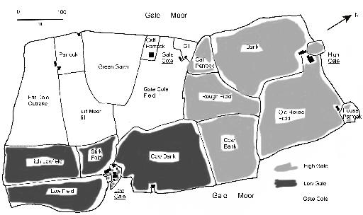
Fig. 1 Thomas Buttle’s map of High Gale, Gate Cote, and Low Gale, 1804.
Source: redrawn from Thomas Buttle’s map of 1804, ZTW III
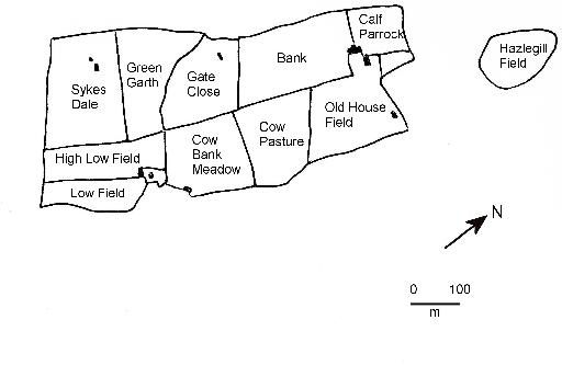
Fig. 2 Extract from Ingleton Tithe map, 1847.
Source: after TNA. IR30/43/234