| JOURNAL 2018 |
| North Craven Heritage Trust |
In December 2015 NCHT members made a visit to Settle Town Hall while the building was still under development and we were allowed to enter a cellar in the north-west corner where water had been found to be coming through the walls. It was discovered that an old slate-lined drainage system in the room had been upset by works done in the past. New drains have now been fitted to take this water to the original central sump in the room. The water level in this sump seemed to be little affected by attempts to pump water out, so it is presumed that water is flowing along some underground system. The cellar rubble walls have now been insulated, water-proofed and plastered and the sump covered. This visit prompted thoughts that water was flowing underground through Settle town centre from the hillsides towards the river so further investigations were made.
The potential source of the water under the Town hall is of course the tanks at the Well Steps, which are now in a rather derelict condition, but with water feeding the tanks from springs in the hillside above, or later perhaps, from the Upper Settle reservoir. They were probably for watering animals since they are rather small and low to be suitable for washing. However, a photograph taken sometime in the early 20th century shows washing on lines by the steps. Water may have been drawn for use in a brewery in the Folly and for use by the local blacksmith in quenching metal wheel rims. There seems to be a well-head at the rear of the Folly at the south end. There are springs along the line of the limestone cliffs running north-south from Castleberg and Townhead. As one walks downhill from Well Steps, Well Cottage is passed on the right at the corner where the lane meets High Street. There appears to be a well-head, now filled-in, at the back of the cottage. There is no cellar but the main floor has been bitumenized, presumably to stop dampness. The property has mullion windows inside so has 18th or 17th century origins. Next door on High Street is King William the fourth Guest House. By courtesy of the owner, one of us was invited to see the cellar in the front north corner where water enters through the wall, flows along an open channel about 10 cm wide and 8 cm deep, and leaves via a drain. Assuming that the water continues to flow towards the river, it perhaps flows via the Town Hall on the Market Place towards Duke Street. The south-west corner, now Gavagan Art gallery, has a sump (now covered) similar to that in the north-west corner occupied by Capella. It is not surprising that individual and groups of properties had their own nearby sources of water and there is plenty of evidence of wells and other water features as noted below.
Brayshaw and Robinson (1932) refer to the drawing by George Nicolson made in 1822 of Settle Market Place. They remark that ‘… the object in the right foreground. It looks very much like a draw-well, but I hardly think it can be intended for one’. This object could be the grindstone wheel of an itinerant knife grinder. There are also people busy at what appears to be a square trough, and buckets or baskets lie on the ground near the wheel (not a drum as might have been used for rope winding in a well) but it is unlikely to be a depiction of a well-head.
Other buildings around Settle Market Place have been investigated, thanks to the owners. The NatWest Bank (now closed) has water in the cellar with water flowing north. Trevor Thorpe, a previous manager, described the water in the cellar as a stream. He had had the water tested, and it was of drinking quality. Pumps were in place to deal with flooding, and a current cashier confirmed that they are still operative. Trevor used to check daily, and he told how, one winter, he had become concerned that the pumps were not coping, and before going home had raised them above the water level. At 3am the following morning he went back to check again, and found that they were submerged, with water almost up to the ceiling. He called the fire brigade, who installed a pump with an extraction capacity of 24,000 gallons per hour, means of entry being through the coal chute at the front of the building. We went to look: it is not there now, cobbled over. “Someone may have trouble in the future”, Trevor observed. But he had only known a flood on this scale once. He added that during the Civil War Cromwellian troops had been billeted in the building. There were (are?) hooks in the walls of the rooms on the top floor (second storey), and he had been told that they were hammock fastening points.
Car and Kitchen has no cellar (just an inspection pit from when it was a garage). Garnett’s has a dry cellar. Castleberg Outdoors on Cheapside has brick-lined vaulted dry cellars. Cave and Crag, now an antiques shop, next door to Boots, have a dry cellar. The drinking fountain in the Market Place (now dry) was erected in 1863, replacing an earlier market cross. It was probably supplied by pipeline from the Upper Settle reservoir. One of the houses in Kirkgate has a well, now with the kitchen built over it.
It is noteworthy that the area of Greenfoot Car Park and the northern field of the Rugby Club is probably what used to be known as Paley’s Puddle, noted by Brayshaw (1932) as being shown on a map of 1774 (actually 1769), originally kept in Liverpool House (with dry cellars). The map places the Puddle between the Folly and Cragdale. This map indicated the route of the proposed canal link to the Leeds-Liverpool canal which was near completion by 1774 (see David Johnson [2007] for information on the proposed canal link). There are no wells shown on John Lettsom’s map of 1751 (see NCHT Journal 2005, p.18) but it does indicate a willow tree in front of the Folly. There are no wells or pumps shown on the 1840 Tithe map of Settle. The ground of the Rugby Club has a pump marked on the 1847 6 inch OS map on the northern field. There is a culverted channel from the Rugby Club down the middle of the southern field to pass behind the bungalows - which flows strongly during wet weather. The water joins Ing Beck to flow into the Runley Bridge millpond, joining the flow from Dog Kennel Mill noted below. The site of Limestone View had to be provided with a drainage system before construction could start. We have recently been in the cellar of the office on the corner of Chapel Street and Duke St. and it is dry. Number 6 Chapel Street has a capped well in the yard behind the house. Cragdale, the old police station, has brick-lined vaulted cellars which were inspected during recent building work, and seen to be dry. Proceeding along Duke Street from the Market Place, Skipton Building Society has a cellar which has been wet but not in recent years. Continuing along Duke Street we find Tarn Cottage opposite the Post Office. Nearby is Nelson’s boot shop and Undercliffe House (Duke Street was formerly named Duck Street!). The name Tarn Cottage is currently associated with the flat above Nelson’s shop. The shop has a cellar which used to flood, but according to Dan Nelson it has not done so since United Utilities installed a non-return valve. Undercliffe House has a watercourse running through its cellar, usually dry, the direction of flow being towards the road. Undercliffe Mews has a well at the front, and a permanently damp area in the back garden which may indicate a spring. Early in 2017 Undercliffe Mews had its own ‘Water under Settle’ problem, when a mains pipe supplying Phoenix Cottage (in front) sprang a leak. Yorkshire Water’s agent, Morrisons, dug in the front yard. The spoil included boulder clay and boulders, indicative of the surface geology. You do not have to dig far at Dog Meadow allotments to find the same. Ashfield House (Settle Social Club) has a dry cellar, but the Golden Lion opposite has water in the cellar. The Triangle in Settle in front of the Post Office is popularly thought to be the site of a former duck pond (but could have been confused with Paley Puddle). Behind the toy shop next to the Post Office was a well, or at least a source of water according to a previous owner. Norlands (originally a Methodist hostel for young mill workers) has a watercourse in the cellar and clear water present in a sump. The water ebbs and flows according to the weather. However, the neighbouring wine shop to the left has a brick-vaulted dry cellar. On walking towards Upper Settle from the Folly one passes Underbergh which has a spring or well in the cellar, now sealed over. Currier Cottage was a tannery and it too must have had a water supply. The old tannery on the Green with its tan-pits behind similarly needed access to water. In Upper Settle are found Well House and Ivy Well Cottage by the Green. There is a water flow through a small ‘trough’ in the yard. In Twisleton’s Yard one water pump served fifteen cottages [Miller, 1973].
Although the direction of the water from Duke Street is unknown, to the south of Settle Market Place is Pool’s Row cottages (on Ingfield Lane) and the start of Brockholes Lane/Watery Lane leading past the Dog Kennel allotments. The allotments are usually referred to as Dog Meadow.
Dog Kennel Mill (Mitchell Lane) was one of Settle’s early cotton spinning mills, powered by water (noted on the 1847/8 6 inch OS map). Water from Mealbank and Springfield culverted under Mitchell Lane by the cottage and pinfold was fed into a mill pond. This later became a covered reservoir just below Mitchell Lane. From the pond it was channelled along the headrace to a water wheel at the mill. The remains of a wall of the mill building can still be seen. From there the tailrace ran downslope, mostly culverted, to enter Brockholes Lane (A ‘drain’ is marked on the 1847 OS map). After flowing along the lane it is culverted to Beck Ing Plantation, then it appears on the surface for some distance, then under the old A65 to the mill pond serving Runley Mill.
It was hoped to find a map with well-heads for public or private use shown for Settle but without success. Jeffery’s map of Yorkshire (1771, revised 1775) is too small scale.There is an 1831 map which concerns ‘Waterworks and course of the pipes, being the property of James Silverwood, for supplying with water the town of Settle in the West Riding of the County of York, by T. Hodgson, Surveyor, Lancaster 1831’. The pipe follows the road from the reservoir in Upper Settle to the Well Steps wells and reservoir then along Chapel Street. No well heads are shown on this map. The Tithe map of 1844 shows Settle Water Works Houses (no. 176) at the northern corner of the Well Steps and a reservoir. Could there be a reservoir under the trapdoor at the Well Steps? The 6 inch Ordnance Survey map of 1847 shows wells and pumps at various points around Settle. The Medical Officer’s Report on sanitary conditions in Settle in 1897 notes the town water supply is from Settle Water Works, wells and springs.
One might presume that before piped water became available residents had to use private or public wells, but their location is not certain. The property deeds available from the West Yorkshire Register of Deeds has a number of references to wells in Settle (see NCHT website under Archives). From the names of prominent merchants, tradesmen and apothecaries involved we can assume that some of the properties were probably in or near the Market Place in the 1700s. For example the Birkbecks’ property in Duck Street had a well in the yard. Benjamin Robinson and William Carr, apothecaries, had messuages with draw wells. There were many individual beer houses in Settle who presumably had their own water supply and several innkeepers with brewhouses had draw wells or well springs. There is an intriguing reference to Lady Well Close at Barrel Sykes. The Springfield reservoir (opened in 1906) in Upper Settle has now found a new use as a fish farm.
A set of photographs of all the streams around Settle leading into the Ribble has been made and accompanies the website version of this article. However, further study of the lines of these streams and their points of discharge into the Ribble is a project-in-waiting!
Any further information is welcomed.
References
- Brayshaw, T., Collecteana Giggleswickiana, Part 1, p.27
- Brayshaw, T., Robinson, R.M., 1932. A History of The Ancient Parish of Giggleswick, Picture of Settle on a Market Day 1822 by George Nicolson (p.174). Halton & Co., London
- Johnson, D.S., 2007. 'An overdose of optimism in the canal age: two abortive canal proposals in the Craven area of North Yorkshire’, Industrial Heritage, vol. 33, no. 1, pp33-41
- Miller, E.M.J., 1973. An appreciation of Settle, pub. Settle and District Civic Society (see NCHT Archives, Settle1973).
- North Yorkshire County Record Office, ZXF M 4/1/1 pp. 366-372 microfilm 2165 West Riding County Council, Report of the Medical Officer upon the condition of the Settle Union, 14 June 1897.
- Paley's Puddle, 1769. Plan of the intended navigable canal from Settle proposed to communicate with the canal now making between Leeds and Liverpool, in the parish of Barnoldswick..., WYAS (Leeds) WYL 162 GA/2/61.4 (Courtesy Dr David Johnson)
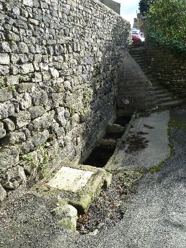
Fig. 1 Well Steps
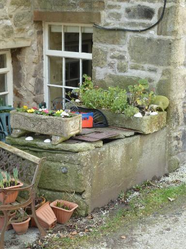
Fig. 2 Well Cottage
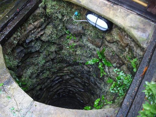
Fig. 3 Undercliffe Mews
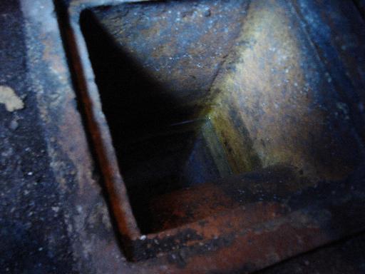
Fig. 4 Norlands