| JOURNAL 2021 |
| North Craven Heritage Trust |
References to a sketch of Settle Bridge by Turner in his Tour of Yorkshire in 1816 are to be found in Brayshaw and Robinson’s book, The Ancient Parish of Giggleswick, and also in the so-called Red Book of papers collected by Brayshaw (in the possession of Giggleswick Church, seen by courtesy of David Fox). The sketch books are held by the Tate Gallery and the one of interest is Yorkshire Sketch Book 2, Turner Bequest CXLV (145) page 32. The simple sketch, labelled Giggleswick no. D11086, can be seen online but it is faint – it appears to show the bridge, Castleberg and some mill buildings. The original sketch can most easily be located using a Google search term ‘Turner sketch book CXLV D11086’.
The viewpoint from which the Turner sketch was made lies near the house Mainsfield on Stackhouse Lane. Stackhouse Lane was the way to Stainforth open to horse riders. A very similar photograph from this point is seen in Speight’s book The Craven and North-West Yorkshire Highlands, p. 97. Trees now obscure the view, but go and see for yourself.
In the Turner drawing we can identify Castleberg as the large outcrop left of centre with Middle High Hill top left. There is another flat-topped hill lower to the right outlined against the skyline - the line coming down abruptly from it is either a wall or the road. Maybe both.
Castleberg appears to be above the skyline so the viewpoint is lower than the Mains, built later than 1816, and the Mains is not a through route. In terms of shape the hill and crag correspond closely to Turner’s drawing. There are some sketchy buildings below Castleberg. There are buildings shown amongst tall trees in the left foreground; the tall building is Bridge End mill, showing the many windows in the side facing the river.
The object just right of centre in the foreground is hard to make out, but is thought to be the bridge. It seems unjustifiable to draw conclusions about the nature of the bridge, such as it being narrow and stone-built.
Turner would select just that part of the scene that was of interest; he would naturally exaggerate those features of most interest and suppress (or omit) those he was not concerned with. Everybody does that – it’s what separates the artist from the photographer. A modern photograph shows a good match despite the changes that have taken place.
One has to remember the conditions under which Turner was working. David Hill tells us that on these tours Turner was averaging 25 miles a day and doing very many drawings - a superhuman performance; in many cases he would not even get off his horse if he was just doing a small sketch like this one. So we must not expect too close a correspondence with actuality. And it was probably raining!
The book by David Hill In Turner’s Footsteps tells us a lot about the sketchbook from which the drawing comes. He says,‘This particular book was more a pocket-book than a sketchbook’ and was ‘stuffed in his waistcoat pocket’ and was ‘full of quick notes, jottings, scribbles of virtually everything that required less than patient study’. Which fits in with the type of cursory sketch it is - more an aide memoire for possible future reference than anything else. Hill also tells us that the book was 5.5 inches by 3 inches, bound in patterned boards with a tanned calf leather spine. He can even tell us it cost 3s. 6d! Quite expensive.
Turner was on his way back to Farnley Hall when he came to Settle and it is worth quoting David Hill again.
Sunday August 11
‘Looking forward to the shooting party at Farnley the next day he set off from Kendal as soon as he could and made all possible speed over the sixty miles back to Otley. He nevertheless made a number of notes in his pocket-book on the journey, a couple at Kirkby Lonsdale, others of Ingleborough as he passed on the road to Clapham, and views of Castleberg at Settle and Pen-y-ghent from nearby.It was late afternoon when at last he arrived at Skipton, and although he was only seventeen miles from home, he had covered 550 miles since he left Farnley on 17 July, and had made 450 sketches on the way’. Turner then did some drawings of Skipton and rode the last few miles to Farnley. He was 41 at this time and no spring chicken. What a man!
So we can imagine him trotting down the road into Settle along the bottom of the Mains and stopping his horse for a moment while he dashed off our sketch of Castleberg. The horse would have been pretty tired by this time and may have been moving around a bit (as horses do, I suppose) which would have had an effect on the drawing as well.
Sources
- Brayshaw, T., Robinson, R. M., 1932. A history of the ancient parish of Giggleswick, Halton & Co., London.
- Hill, David, 1984. In Turner’s Footsteps. John Murray.
- Hill, David, 1998. Turner in the North, Yale University Press.
- Speight, H., 1892. The Craven and North-West Yorkshire Highlands, Elliot Stock, London. p. 97.
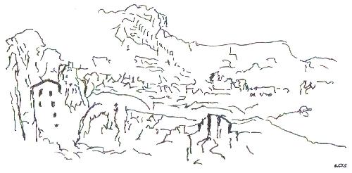
A rough sketch with more contrast has been made Michael Slater.