| JOURNAL 2022 |
| North Craven Heritage Trust |
In recent years the boundaries of several townships in North Craven and their ‘furniture’ have been walked and photographed by Rita Hudson and Sheila Gordon. These photographs are held by NCHT [1]. Boundaries have suffered some change over time [2]. Manor Court records for Ingleton, Rathmell and Austwick/Lawkland note that boundaries have been checked on foot and by horse in times past, and no doubt on many occasions for centuries gone by as a legal precaution against incursions by neighbouring townships. The disputed boundary between Austwick and Horton is a well-documented case in point, accompanied by maps of Ingleborough drawn by Saxton in 1603 and Newby in 1619 [3,4]. A boundary survey for Stainforth was carried out in 1999 by Dr David Johnson and reported in the Stainforth local history account ‘Stainforth Stepping stones through history’ [5].
Beating the bounds was a way of ensuring they were remembered by younger inhabitants, and done perhaps every seven years. Elsewhere the priest with churchwardens and parochial officials headed a crowd of boys who beat the parish boundary markers with green boughs. Sometimes the boys were whipped or violently bumped on the boundary stones to make them remember. In areas where boundaries had few obvious permanent landscape features this was more important than in areas such as in Craven where hill tops, river junctions, lines of crags and large boulders such as Fourstones were prominent.
Early documents relate boundary details and are brought together here to show that current parish boundaries have ancient origins, not surprisingly. Many names have recognizable modern counterparts but many have disappeared or changed.
Burton Chase
The boundary of Burton Chase surrounds the area considered in this article (Figures 1 and 2). A Chase gave the right to hunt by Royal Warrant. The Burton Chase was granted to the Moubray (Mowbray ) family in the 1100s and extended in 1203/4 to include Thornton, Horton, Austwick, Burton, Kingsdale, Blea Moor, Whernside and Cam Side. The Earl of Derby acquired the Chase after 1485. The Chase covered several manors with various owners and rights of the Chase were excluded from any manorial rights [6]. During the Tudor period and after, forest law had largely become anachronistic. Crown jurisdiction over the Chase appears to have been held jointly with manorial jurisdiction [7]. Higham [8] discusses the boundary in detail, as found in the inquest of 1307 [9]. Many of the names of points on the boundary are easily recognized.
The metes and bounds of the chaces of Burton in Lonnesdale begin at Langbreg’ towards the west, between the county of Loncaster and the county of York; and so from Langbreg’ to Douuegil’, and so from the head of Douuegill’ to le Pyk’ of Gragret’, and so through Ulfstokwald and the boundaries of Dent between the land of the said John [de Moubray] and the land of Henry son of Hugh to Cirkestanes, and from Cirkestanes to Gemmesyke, and from Gemmesyke to Caldekelde above Camb, and so from Caldekelde above Camb to the top of the hill of Penegent, between the fees of the said John de Moubray and Henry de Percy, and from Penegent to Durlaykhege, and so by the boundaries between the fees of the said John and Henry de Percy to Youcrosse, and from Youcrosse to Whettyngstan’, and from Whettyngstan’ to a place called Langemangrave, and so by Knote ... to Caldestan’, between the fees of the said John and the earl of Lincoln, and from Caldestan’ by a place called Harlaw to le Tong of Brounmore between the county of Lancaster and the county of York; and so by Fourstanes to Kirkebek’, and from Kirkebek’ to the water called Whenyg’ and to Littlewath, and from Littlewath below Ravencros, to Aid Weryngton and Grythawe and from Grythawe to Langbrig’.
A similar account is given in 1682 [8] as follows and is not referred to as Burton Chase, but rather Burton manor and parish, which seems to be incorrect.
To the first Article the said Jury and Inquest say that the Butts and bounds of this Mannour and parish in the Article named are as Follows. And the same doth Butt and Bound and Adioyne upon the severall Lordshipps and places hereafter mentioned: Beginning at a place called Langber and so going westwards Between the Countys of Lancaster and Yorke to a place called Lords Myre and soe from thence to a place called stirgapp from thence to a place called Doves-gill from thence to a place called Hurder from thence to the Pike of Gragereth and from thence to the County Stone And soe by the Oakestake on the Waye to the well under the Windhawes. All along by the Divicion and boundary of Dent to the Orkestones from thence to a place called Gennysike from thence to the Colds Colds upon Cam. And from thence southwards by the out bounds of the parish of Horton and soe to the Top of Pennygent from thence to a place called Durelakehedge And soe to a place called Ewecrosse And from thence to a place called Whettingstan And thence to a place called Langrand alias Langmangrand And from thence by Knoteround alias Knotteranum to a place called Colderstone and from thence by the Cross of Gretey And soe along the Bound that divide the Countys of Yorkshire and Lancashire to a place called Kirk-Beck and soe downe the same to the River Wening And from thence to a place called Little wath under Ravensclose and from thence to Old wennington and from thence to the River Greeta And soe all alonge the same up to the said place or Close called Longber.
The manor boundaries now discussed lie within the Chase boundary. The Thornton-in-Lonsdale and Bentham boundaries on the west side of the Chase are defined by the Ingleton and Clapham boundaries.
Austwick/Lawkland boundary with surrounding townships
These two manors had separate courts but the boundary described here is for the two manors at 1750 [10]. The boundaries of Austwick and Lawkland parishes have been in existence since at least 1851 at the time of the drawing up of the Tithe map.
The Bounderies of the Manor of Austwick and Laukland as the same were Rid and walked on the 26 and 27 of June 1685 And again on the 11th of September 1719 and again 6th August 1750.
Begin at the Lords Seat and go down Willen Cove Rake Then to Sulber Slack, so to Howgill White Rig on Moughton Then to Trougill head, so down Moughton to the head of Coums Close, Then on the North side of the said Coums Close to Atterpool Brigg, Then to the Cowfore or Midstream in Rible, so to the Hanging Stone on Swarthmoor,
E Then up the south side of Swarthmoor to Sumpinpot, so to a little Hurdle of stones in the north west end of Middleber, Then to another Hurdle of stones a little above Middleber Cove, so to Buck Cove, Then to the Lords stones under the Scarr, so to Mirk Steel near Armitstead, Then to Overstub Gate, so to the Water Grass Garth Then to the Resting Stones, E (reversed)
And so up the height of Bolland Knots, and from thence between the Lordships of Austwick and Clapham to the Fryar Syke so to Dubsike, Then to the Hare Stone, on Lawzins, so to the Double Dyke in Weskoe, Then to the standing stone on Kirkbank so to the Arks on Ravensber, Then to Lissakel Well so to Fairy fould, then to Dudderhouse hill, so to Trace Hill Then to White Stones, And so up to the Lords Seat again.
Note Between these marks E E(reversed) are the Bounderies between Laukland and Giggleswick and Stainforth.
Giggleswick Boundary
An item found in the Chatsworth House archives is the verdict of the Giggleswick manor court held 26th September 1579 which has become separated from the book of the manor court held in Leeds Special Collections [11]. The boundary description presumably was needed at Chatsworth House for legal record purposes. The Anglicized spelling version is as follows:
... we find that my lord’s boundaries do begin without the field at a place called the Watter Fall at Kockhead. From that watter fall to one Copte stone of Aquoth noke. From that stone to a place called the Little Ladd Knott. From that knott to the Croke of the Dubbes. From thence to Cluntergill Foote, so up Cluntergill to the Four Corner stone. From that stone to the Resting stones. From thence to Dowker Dubbes. From thence to one Hurtle stones of the west side of Rowntescorth. From thence to the yew stub of Havelhaw, then to the Mirke Stile. From thence to four stones of the Ward Hawes. From thence to one Hutter of stones of the laides. From thence to Myddle Barr Coove. And so to Myddlay Barr Walles. And from thence to the sumppe in Kesden. From thence to Fellgill Well and so to the myddest of Rybble.
Many of these names cannot be located on a modern map. There is some coincidence of names with part of the abutting Austwick/Lawkland boundary. It is considered that the boundary is being followed anti-clockwise on the current parish boundary.
| Giggleswick | Austwick/Lawkland |
|---|---|
| Resting stones | Resting stones |
| Mirke Stile | Mirk Steel |
| Hutter of stones of the lands | Lords Stones under Scarr |
| Myddle Barr Coove | Middleber |
| sumppe in Kesden | Sumpinpot |
The River Ribble then forms the rest of the boundary but it is not named, perhaps because beyond dispute.
Ingleton Boundary
A document dated 1754 describes the boundary of the manor [12].
The Boundaries of the Manor of Ingleton in the West Riding of the County of York rid on Friday the twentieth day of September one thousand seven hundred fifty and four pursuant to Notices before published in the several Parish Churches within and next adjoining to the said Manor by Edward Parker Esquire Lord thereof accompanied by the several persons whose Names are hereto subscribed.
Beginning where Thornton River called Doe runs into and meets Ingleton River called Greet so down said River unto Parks on an old Watercourse there to the River again so down said River and then westward by Guyholme to Greeta Gill and up said Greeta Gill to Sharps House and through part of it and on Best Beck by John Howson’s of Gill on the East Side of Ravens Close to the River Wenning and so up said River to Mill Air and on the south side of the Fence in said Mill Air to the River again and up the same to Eska Beck and Eska Lane by the backside of Eska House to the Boundary stone on Beckwith down Beckwith Sike to the River Wenning so up said River to Meer Gill and up same to the Common called Bentham Moor to the Graystone on Whitestone Green on the East Side of Threap Haw to the Road leading between Bentham and Settle and on the same to Sandy Fore by the Double Ditch to Goat Gap and on the East Side thereof up a Rivulet running cross to the Highway to Blindfield Well and so on Blakebank by the Fence on the West Side thereof to the Common and so straight up to a hurdle of Stones on the Gray Scarr and to the Goad Dub and from thence upwards to a hurdle of Stones upon Green Plate so to Guy Sike head and to the hurdle of Stones on Little Ingleburrow and on the East Side of Limestone Side and Cross Ingleburrow down Fair Weather Sike to Meer Gill down same to Bold Haw and up the River Weese to the Chapel and on Weather Coat Clough and by the Gill Head to the Stone in the Mire up a Clough in Ellerbeck Ground and by a Gill to the Top of Whernside then to the Hole in the Fell End so to Brockaslack in a direct Line to the Standing Stone through Green Barn to Ravenwray and then down the River Doe where it runs into and meets Ingleton River where Began.
Boundary of Manor of Newby
An undated document describes the boundary of the manor [13].
From Woofall yeat otherwise Wilfales up the water courses above ye chapel & from thence by ye Fences of the Westside of the Land belonging Wethercoat to the Gill head to a cross back (?) of Gill head Green to … … at Ellerbeck so up by that watercourse in ye middle of Ellerbeck field head up to the Ridge of Whernside Then all along Whernside over the Piked hawe … as the rain water divides itself to a Pike or little hurdle of stones erected at ye South East side of the Tarns upon Whernside and from thence South East down the moss or rainwater divides to another Pike or hurdle of stones upon (Rocky balbeck?) in (ye moss) Then forward as the Water divides itself to another Pike or hurdle of stones on ye north part of Cravenes Wold (Cravenshalswath) And from thence round by ye Ridge of the moss north eastward to a hurdle of stones on the hillside called the head of Little Dale then up Bleamoor End Eastward to another pike of hurdle of stones above the last mentioned & so directly up Bleamoor Cragg Then across the moss south Eastward & down by a small water course to a … … called ye Hermitage house in helmit rake otherwise Blackrake Then north east directly upon Raram Rigg to Mossdale beck Head otherwise called Whiniston (Keld?) And so to ye Corner of Wensleydale fields formerly called Richmond Forrest Then south east & down Wooful Bents and up Barly moss dike to Snaesfell End & so up by the hause to Gavel Gap & from thence along by Cam hause to cald Keld upon Cam then down unto ye Bottom of the valley to a place called Stanepapan otherwise standing pan Then straight up the moor side & long by Outershaw new dike to Anan Ward so down south west by ye Middle of Greenfield Then to Cosh well & so down Thorowgill & Swargill to Ribble & from Ribble up by the Hause to hewring yeat & from thence straight up to a Pike or hurdle of stones on Moughton End Then round Sulber otherwise solbecke Nook & so to Crummack head from thence to Dutter house End & so by the Grange head to ye Lords Seat And from thence to ye Beacon east(?) of Ingleborough for ye Candwellknot to (down) Meregill to moorwall(?) Then to …wodd to …ward a place called Loaddub then up ye water(?) on ye (west) side of fryer(?) wood to woolfall yeat.
Part of the boundary on the north and north-east is discussed by Mary Higham who locates various names. These date from an Inquisition held in 1307 concerning the Chase of Burton in Lonsdale and 12 and 13th century monastic grants [14].
Ingleton and Moughton Fell (Saxton map of 1603 and Newby map 1619)
These maps concern disputed grazing rights rather than manorial or townships boundaries but the named points are of interest and the boundaries part coincide with townships boundaries [3,4].
On the Saxton map
Ingleborow beken; Wharffe Mosse; Theife Mosse; Horton Sty; Soulber; Foure Graines; Duttons Hull; Witton Cove; Freckle Hill; Cromok; Fell Close; Lords Seate; Hamerton Fell; Combe Nabbe
On the Newby map.
Earthsdale Gill; Witton Cove; Soulbar slack; Cromok Heade; Horton Sty; Fowre Graynes
Settle and Langcliffe boundary
This document is written in a 16th C hand and spelling and the translation from Latin is not guaranteed [15]. It is not clear what boundary this represents.
Here the division between Settle and Langcliffe one may see a great stone which is between these towns, ascend so as to large stones lying marking out as far as to Rumegaite and from as far as to the Blapott, and from Blapott as far as the Nowelthorne and as far as to a great stone above Somerake Bank and from Somerrake bank as far as to the Groves and thus as formerly by the Groves as far as the rydeknottes and thus as far as to Symondhailby and from here as far as the Dryryghende and from there as far as to the Foxholes.
None of these names are identifiable apart probably from Dry Rigg quarry. If there was a great stone between Settle and Langcliffe it may have been broken up for walling, although a conspicuous large stone is in the wall at OS grid reference 825 646 just north of the current parish boundary. A Settle court roll for 1599 [16] notes that ‘John Altham took away a boundary stone with some stones for a wall’.
A series of grants made in the 12th and 13th centuries concerns Stockdale surrounded by a ditch and hedge. The boundary points mentioned are: Athulnesmire, Wlfvesdalals, sike next to Aleward, and two great stones of Middlehou [17]. A 17th century map of Stockdale showing its boundary is of value [18].
Rathmell manor boundary
A verdict of the manor court held in 1687 includes a boundary survey, but a rather limited one [19]. The document is in a state of disintegration with many words missing.
We all say and beelive the true … boundary and Extent of the Mannor is as followeth first the lower end of Stubbing to be north(so) of cockett moss, then … banke topp, then to risting stones, then to Battersby pi… Corley moss, then to hollow gill, then to the beckmouth so … side to hurrell crossing rible to the lower end of Stubbing.
Stubbing can be located in the north east corner since the tithe assessment and map records this name. Bank and Cockett Moss are known to lie on the north and west sides. The Resting Stone marks the most westerly point but thereafter the names have not been located.
Conclusion
Our parish boundaries are ancient, perhaps in part defined just post-Conquest. The challenge to the determined walker is to find the intermediate locations between those with names which have modern counter-parts.
Sources
- Contact NCHT for photographs. 500 Mb ‘Boundaries Reduced’ archive (1815 files). Requires memory stick to be supplied for transfer. Mainly Settle, Stainforth and Langcliffe and some Horton.
- Gordon, S., Hudson, R., 2007. Moving boundaries. NCHT Journal, pp. 31-32
- Slater, M. J., 2004. Disputed boundaries plans of Ingleborough. NCHT Journal, pp. 13-15
- Slater, M. J., 2004. Places and boundaries on the surveys on Ingleborough by Saxton and Newby. NCHT Journal, p. 16
- Johnson, D. J., 2001. Chapter 14 in Stainforth Stepping stones through history. Stainforth History Group.
- Howard, C.A., 2007. A history of Kingsdale in the parish of Thornton in Lonsdale. http://www.ingleborougharchaeologygroup.org.uk/pdfs/Kingsdale%20Head%20History.pdf
- Stephens, A., Gregory, S., 2009. Burton in Lonsdale in the late medieval period. NCHT Journal, pp. 13-16
- Higham, M., 1994. The boundaries of Burton-in-Lonsdale Chase. YASJ, vol. 66 pp. 91-105. Survey made in 1682 LRO DDK 1541 7a and Miscellaneous bailiff’s accounts, Surveys and Rentals, in 1682 LRO DDK/1553/4
- YAS Record Series, Vol. 37, 1906. Yorkshire Inquisitions in the reigns of Henry III and Edward I, part iv. CXXXV John de Moubray. Metes and bounds of the chaces of Burton-in-Lonsdale and Nidderdale. pp.148-149. https://archive.org/details/cu31924084250616
- Manors of Austwick and Lawkland. NYCRO mic 1577 ZXF 3/1
- Chatsworth House archives item L/28/8, 1579
- 1754. Manor of Ingleton. NYCRO ZUC 3/1
- Manor of Newby. NYCRO mic 1577 ZXF 3/5 undated
- Higham, M., 1992. The ‘Regione Dunutinga’. A pre-Conquest Lordship?, Centre for North West Regional Studies no. 6 Summer 1992. Lancaster University pp. 43-48
- YAS Record Series 1934. Vol. 90, vol. ii., p.167. Charter no. 676
- Settle Manor Court April 41 Eliz (1599).
- YAS Record Series 1934. Vol. 90, vol. ii, pp.20-23. Stockdale charters nos. 420-427
- Lancashire Record Office, DDKE/Box 100/5
- Yorkshire Archaeological and History Society, MD 335/6/54/57. Special Collections, Brotherton Library, University of Leeds.
Locations and SD sheet reference
|
| ||||||||||||||||||||||||||||||||||||||||||||||||||||||||||||||||||||||||||||||||||||||||||||||||||||||||||
| Newby (NYCRO) | OS Ref. | Newby (Higham) |
|---|---|---|
| Woofall (Wilfales) | ||
| Chapel | 737 773 | |
| Wethercoat | 737 775 | |
| Gill Head | 735 778 | |
| Ellerbeck | 731 785 | |
| Whernside | 738 813 | |
| Piked Hawe | 735 805 | |
| Pike | ||
| Tarns | 743 822 | |
| Rocky balbek(?) | ||
| Pike | ||
| Cravenes Wold | 760 828 | Cravenhalswath |
| Little Dale | ||
| Blea Moor End | ||
| Blea Moor Crag | 773 825 | |
| Hermitage House (Blackrake) | 790 821 | |
| Raram Rigg | ||
| Mossdale Beck Head (Whiniston) | (773 825) | Mosdalebek |
| Richmond Forrest | ||
| Wooful Bents | 787 841 | |
| Barly Moss Dike | ||
| Snaesfell End | ||
| Gavel Gap | 812 832 | |
| Cald Keld upon Cam | 826 833 | Caldekelde |
| Stanepan | (815 789) | |
| Oughtershaw | ||
| Anan Ward | ||
| Middle of Greenfield | 823 785 | Medium Grenfeld |
| Cosh Well | 833 778 | |
| Thorowgill | ||
| Swargill | 838 757 | Swarthgill |
| Hewring Yeat | ||
| Moughton End | 790 720 | |
| Sulber | 785 733 | |
| Crummack Head | 775 728 | |
| Dutter House End | ||
| Grange Head | ||
| Lords Seat | 758 749 | |
| Beacon east of Ingleborough | 742 745 | |
| Candwell Knot | ||
| Meregill | 741 756 | |
| Moorwall | ||
| Load Dub | ||
| Fryer Wood | ||
| Woolfall Yeat |

Fig. 1 The Bounds of Burton Chase (courtesy Tony Stephens and ref. 14).
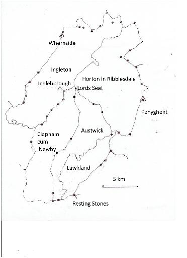
Fig. 2 Manorial boundaries with known locations