| JOURNAL 1993 |
| North Craven Heritage Trust |
Come wind come weather, and on the odd fine day too, the Trust's programme of guided walks has continued during the year. These are most efficiently organised by Mrs. Phyllis Houlton, and are thoroughly enjoyed by the participants. The walks, which take place on the first Sunday of each month, except July and August, give members an opportunity to appreciate the landscape, history and buildings of the area at first hand and in convivial company. As one regular walker says: "We feel that our NCHT Walks alert us to a wider view of our 'heritage'."
Each walk lasts about two hours, with shorter options available for those whose stamina is limited. The walks are listed on the Membership/Programme Card, and begin at 1.45 pm. Dogs are welcome, but must be kept on a lead. The walks may be cancelled at short notice in the case of very bad weather. Phyllis Houlton is happy to answer any queries (Tel: 0729 822824).
The Trust would like to thank Phyllis very much indeed for her indefatigable efforts each year to organise such an excellent programme of walks for us. This year we publish Walk Reports on some of the outings we have enjoyed recently. Through these we hope to convey to those who might not be able to join in the walks some of the fun and interest which they bring, as well as to encourage more Trust members to leave their firesides to come and join us!
NORTH CRAVEN HERITAGE TRUST WALKS 1991—1992
6 September 1991:
Leader—Mrs Proctor
Meeting Place—Long Preston Station
This was a circular walk north of Long Preston along public footpaths and bridleways crossing Scaleber and Bookilber Becks to Bookilber Farm returning over high ground to return to Long Preston by the Church. The theme was "Keeping open public footpaths and Bridleways". We continued foraging for edible fungi including "The Tub". An excellent walk, invigorating and full of interest.
Phyllis Houlton
2 February 1992:
Leader—Maureen Glass
Meeting Place—Langcliffe
The intended walk was to go above Langcliffe via Winskill to Catrigg Force, down the stony lane into Stainforth and back via Langcliffe. In the event, the mist came down and feeling the walk could be dangerous we came off the high ground at Upper Winskill returning to Langcliffe by the lower fields. Phyllis Houlton
March 1992
Leader—Brenda Capstick
Walk from Ingleton
Disappointing weather with low mist precluded a walk on the hills and the initial route to look at some of the early signs of coal working was abandoned as the drizzle became heavier. Instead the party of five walked down the A65 to the bridge across the River Greta, passing the tollhouse which dates from the alteration to the Keighley-Kendal turnpike in 1823 to cross Newby Moor from Clapham with a new bridge across the river south of Ingleton. Previously the turnpike had followed the high road from Clapham past Newby Cote and Holly Platt to meet the Richmond-Lancaster turnpike and descend into Ingleton past the church and over the two bridges spanning the rivers Twiss and Doe before they meet to become the Greta.
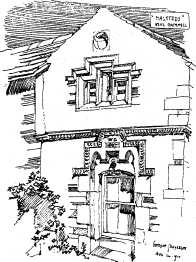
Passing over the present bridge into the parish of Thornton-in-Lonsdale we followed the footpath along the river bank and through the meadows to Scroggs Wood. Heading north, we crossed the field where the local inhabitants tried without success to develop a spa at a sulphur spring in the early 1900s. No sign of the building or indeed of the spring can now be seen but Mr. Chapman gave us information on chalybeate wells and springs and their chemical and geological origins. Having crossed the A65 again, we passed Halsteads, one of the oldest houses in the locality with a datestone of 1671 and the remains of a cruck roof, and walked over the railway bridge for the disused Ingleton Branch line (to Lowgill and Tebay) to the church of St. Oswald where the NCHT New Year concert by the Leeds Parish Church Choir had been held. Thornton is an old parish now much diminished and, whereas initially Burton-in-Lonsdale had been a chapelry of Thornton, now the reverse is the case. The walk then took us across fields to come out on the road to Dent, between Thornton Glebe farm with its massive stepped chimney and Thornton Hall farm with the ruins of the old manor house behind, and then back through the fields to Ingleton reaching the foot of the viaduct by the entrance to the Waterfalls Walk at Broadwood. Passing the slate boundary stone between the parishes of Thornton-in-Lonsdale and Ingleton (as it states) "in the Wapentake of Ewecross with Staincliffe" now embedded in the pavement at the bridge end, we made our way back to the Community Centre where we had started. Brenda Capstick
10 May 1992
Leader—Ian Roberts
Meeting Place—Wham
Think water, think Wham. It was of bogs, bridges and enclosures that Ian Roberts talked as we walked in a circle on higher ground round a central boggy area. Wham is south-west of Settle; Giggleswick and Rathmell commons separate it from the Keasden to Slaidburn road, and we started in an easterly direction skirting the high ground of Birkshaw Crags. It was explained by the leader that the stone walls which are so much a part of the northern scenery are of two sorts. The older ones are built in a curve because medieval minds were astute to the fact that this was the means of encroaching on to the wet, boggy moor. Later straighter walls were constructions of the second and third quarters of the seventeenth century, and enclosed the less desirable boggy areas, with their pools of water known as dubbs.
Becks have to be crossed; fording is the simplest although wettest way and a packhorse bridge was built between Lower and Higher Sheepwash Farms. We kept our feet dry. These descriptive names are echoed over the fields with Swainstead and Low Bank Farms. Maureen Ellis
7 June 1992
Leader—Kathleen Firth
Meeting Place—Southerscales Nature Reserve
Southerscales lies on the side of Ingleborough and has been a reserve since 1979. Morphologically it is fortunate in comprising acidic grassland and limestone pavements which each have their own specific flora. The site is seasonally farmed in a structured traditional way, the cattle preferring the young purplish-green leaves of purple moorgrass in the summer, while the sheep avoid the coarse tufted mat grass unless very hungry but eat the shoots of heath rush during winter and the early growth of cotton-grasses (sedges) in spring. Kathleen Firth's considerable botanic knowledge and intimate familiarity with the site was exciting. She pegged out a control metre grid demonstrating gradual intrusion of heather into the acidic grassland. An area where frog orchid had previously flowered was pointed out, and the easily missed mountain everlasting flower was seen. On the return route below a limestone outcrop, native wild columbines flowered. A comprehensive guide to the reserve is published by the Yorkshire Wildlife Trust Ltd. Southerscales Nature Reserve became part of the Ingleborough Nature Reserve in 1993. Maureen Ellis
4 October 1992
Leader—Len Moody
To Whelpstone Crag
Whelpstone Crag is a prominent gritstone outcrop at the eastern end of Bowland Knotts, just inside the Lancashire boundary, about 5 miles west of Rathmell (Grid reference SD 759 591). Perhaps one reason that it is not very well known is that two sheets of the Pathfinder map (both the Bentham/Clapham, and the Slaidburn/Forest of Bowland sheets) are needed to approach it from the north and east. Its modest statistical height of 371 metres entirely fails to convey the loftiness, loneliness and spaciousness of this eminence. Whelpstone Crag can be reached by a number of routes, from the south starting from Tosside, from the west from Stocks Reservoir via Halstead's Farm, from the east from Rathmell or Wigglesworth all making use of public rights of way. On 4th October, our approach was from the north-east using Giggleswick Station as an initial rendezvous. To keep the distance within the 6 miles and 3 hours stipulated, we then drove along the Eldroth road, turning left on to Storth Gill Lane leading to Wham Lane, and parked our vehicles on "the Moss" just east of Sangfroid Farm. The map shows a spot height of 218 metres where we left the road and set off up the fell (Rathmell Common), following a sometimes squelchy line past some disused grouse butts aiming for the north-east corner of the Gisburn Forest plantation at Brown Hills (Ref 759 609). From this point the route continues southwards along the edge of the plantation, with the ridge of Whelpstone Crag now clearly in view. After about a mile, negotiating various ups and downs, the most convenient route to the summit is to aim for the centre of the ridge, and look for an opening in the wall which traverses the centre, pass through and make for the trig point now clearly in view to the west. Don't follow too straight a line, but for the best views keep a little to the right and follow the cliff edge. Rest a while at the summit if it is not too windy, digesting the panoramic landscape in all directions. To see a detail of special interest drop down the craggy slope at the western end and see if you can spot the massive, old, abandoned grindstone lying on its side just beyond the wall.
The return route then requires an "about turn", and follows the right of way eastwards along the foot of the crag towards the beautifully located, but also abandoned, farm of Whelpstone Lodge (What memories those stones must carry!) Then it is (mostly) down hill all the way, along rights of way through enclosed land, with (mostly) excellent ancient step stiles, by way of Owlshaw, Black Hill, Bull Hurst, Higher Winterscales, Low Fold Bank, and north over the fell to Sandford once more. The prospects, north towards the Three Peaks and Ribblesdale and east towards Airedale, are unforgettable. A notable part of our Craven Heritage.
Len Moody
6 December 199
Leader—Jill Sykes
Walk in Crummackdale
14 walkers met at the Cross in Austwick, but because of the lack of available daylight, we took the cars up Crummack Lane and left them at the end of White Stone Lane.
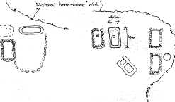
With the permission of Mr. and Mrs. Haw, of Crummack Farm, we explored two groups of possible hut bases and old enclosure walls at the head of the dale, together with some individual hut profiles. Two of these were excavated by Arthur Raistrick in the 1930s, and dated by him to the Iron Age, about the time of the start of the Roman Occupation. Where the walls are exposed it is presumed that these are the sites of the excavations by Raistrick. One authority suggests that, as certain metal ores were found, there was some industry on the site.
Biting wind and rain made further exploration uncomfortable, but we completed the walk by going through Beggars Stile, Thieves Moss and Sulber Gate. We noted the interesting Limestone formations. We then returned on part of the Clapham to Selside track until a fork to the east brought us down again to Crummack Farm and on to our cars with just enough daylight left.
7 February 1993
Leader—Hilary Baker
Meeting Place—Long Preston Green
The walk started at Cow Bridge and at first followed the Ribble, then veered west towards Wigglesworth Hall. As the footpath passed Hamerton Hall some of the Hamerton family history emerged from the Group. Many historic farms were passed on the way, Cross Gates Laithe, Stubb, Deep Dale Head and High Scale to name only some. This was an ingenious and well constructed walk linking paths that were not obvious to the casual map reader.
Maureen Ellis
7 March 1993
Leader—Maureen Brocklehurst
Meeting Place—The Cross, Austwick
Leaving the cars on the grass verge at the entrance to the quarry, we walked round the spoil heaps of Dry Rigg Quarry to the Foredale Cottages and contemplated The Unconformity. After some scrambling we walked the more gradual slope to the summit of Moughton 427m, returning by a valley with shake holes, beneath limestone cliffs and down a steep path along the edge of Dry Rigg Quarry to our cars. Distance 4 miles
Time: Three and a half hours
Weather: Dry but hazy
Maureen Brocklehurst
Editor's Comment:
It is hoped by careful recording of the walks arranged by the Trust to accumulate local information about buildings and natural history which might otherwise be lost. The preceding vignettes of the walks that have taken place in 1992-93 begin to address this task. Maureen Ellis
SUNDAY WALKS 1993
Leader Phone Venue
February 7th
Mrs Hilary Baker 0729-840609 Long Preston, Green
March 7th
Mrs M. Brocklehurst 05242-51483 The Cross,
Austwick
April 4th
Mrs Enid Parker 0729-823792 Horton-in-R'dale
Car Park
May 2nd
Mr Len Moody 05242-61128 Giggleswick Station
Car Park
June 6th
Dr Lesley Todd 05242-51245 To be advised
Austwick/Clapham
September 5th
Mr Arthur Lupton 0729-823987 High Birkwith
Map Ref. 803-770
October 3rd
Miss Brenda Capstick 05242-41240 Thornton-in-
Lonsdale Church
November 7th
Mr John McGeoch 0729-850462 Gisburn Road,
parking Hellifield
December 5th
Mrs Phyllis Houlton 0729-822824 Greenfoot Car Park,
Settle
All walks commence at 1.45 p.m.
Any queries please ring Mrs P. Houlton 0729-822824
J1993p10_20_files/tmpBB9-5.jpg
J1993p10_20_files/tmpBB9-6.jpg
J1993p10_20_files/tmpBB9-7.jpg
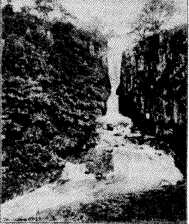
Catterick Force
J1993p10_20_files/tmpBB9-8.jpg
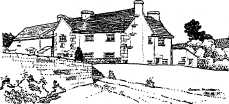
Typical Farm House near Rathmell

J1993p10_20_files/tmpBB9-9.jpg
The Plants of Southerscales drawn by Mary Farnell for the Yorkshire Wildlife Trust leaflet
J1993p10_20_files/tmpBB9-10.jpg
J1993p10_20_files/tmpBB9-11.jpg
Sketch plans of possible dwellings, mainly grass covered banks approximately 2 ft. high.
J1993p10_20_files/tmpBB9-12.jpg
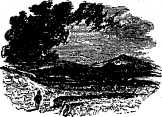
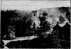
Clapham: start and finish to so many walks