| JOURNAL 1995 |
| North Craven Heritage Trust |
6 February 1994
Leader - Mary Hudson
Meeting Place - Austwick Green
The walk crossed the bridge in Austwick and went past Jock Riddings farm and on up to Wharfe Wood. Hargreaves barn was passed and pausing to take in the view from Pot Scar we went onto Little Stainforth. The return was via Feizer back to Austwick.
Maureen Ellis.
6 March 1994
Leader - Len Moody
Meeting Place - Bentham
Some walks go off to the heights and the lonely places. This one was designed to introduce people to an area so familiar that they scarcely know it! Despite early March weather, some 18 folk gathered for the walk around "Bonnie Bentham" (as it was described by Harry Speight almost 100 years ago). We began from Lairgill, crossed Pye Busk, Cowslip Hill and the Church Fields to Bentham Bridge (with a quick look at the "fairy bridge"). Thence we took the eastwards route via Staggarth, "Joan's Seat", and Dawson's Close (derelict) to Far Sunny Bank, and crossed Mewith Lane, up past the former Mill Dam Cottage to find the original "mill dam". There we turned west via Seal Style, Beck Grains, and Holly Tree to the site of (former) Ward's House, where as time was running out we turned north and returned to base via Branstone Beck, Shaky Bridge and Ridding Lane, Sadly it was a day when none of the distant views was visible, but there were plenty of local features of interest. We had a good opportunity to observe the "gentrification" of this part of the countryside, though it seems without too much disturbance of traditional farming.
Len Moody.
10 April 1994
Leader - John Chapman
Meeting Place - Austwick
A group of nine started from Austwick, some to walk back to Settle, others on a circular route back to the village.
After a long period of dull wet weather it was a fine afternoon, blue skies with sunshine and the distant view of snow-capped hills. The waterfall in Wharfe Gill Syke was magnificent after the heavy rain and early signs of spring were seenŚwood anemones, celandine and the leaves of wild strawberry. One incident enlivened the day when Joe Wilson, seeing a sheep in difficulties, vaulted the wall like a seventeen-year old, and delivered her lamb. We were impressed, he nonchalant.
The walk was routed by Feizor Gap, above the hamlet, onto Pot Scar where those returning to Austwick left the group. The others continued along Giggleswick Scar to Settle from where Joe kindly ferried drivers back to Austwick to collect their cars.
Constance Chapman.
8 May 1994
Leaders - Arthur and Helen
Lupton
Meeting Place - South of High Birkwith farm, Horton-in-Ribblesdale Map Ref: SD803 770
We left the cars at the junction of the track to Low Birkwith where parking is easy and discreet, and walked through High Birkwith Farm and up the stony track towards Old Ing until the turn off to Nether Lodge Farm to the west (about 100 yards from the gate). Just before God's BridgeŚno one ventured under it, though this is often quite possibleŚwe turned upstream to the classic resurgence at Browgill Cave. No one entered hereŚthough it is easy for say 50 yards, paddling and with torches towards the endŚbecause we knew that there was a dipper's nest near the entrance which no one wanted to risk disturbing. And we saw no cavers (full equipment necessary) emerging after their passage from Dry Lathe Cave.
We walked upwards following the wall to meet the Pennine Way and along to Dry Lathe cave (also known as Calf Holes). Some looked in, having negotiated the steep stile from the track and others enjoyed the little valley of the stream which flows between two drumlins before it drops 10 metres down the mouth of the cave: Then we continued along the track to Old Ing where we began the circumambulation of Dismal Hill.
Following the Pennine Way across boggy ground (keep to the south wall as far as the barn, then strike NE over a rise and down to the junction with the path from High Green Field Knott)Śwhere we forded an attractive stream crossing.
Continuing on the Pennine Way southwards for a bit over half a mile until an obvious and rather eroded way on the right took us a little backwards, up and then down and along a pleasant easy track to above (east of) High Birkwith Cave. This is on private land and cavers sometimes emerge from it (it merely drains the many sinkholes to the east) so we did not go there as a group. Sometimes a powerful stream pours out and can be heard cascading down the wooded valley to High Birkwith Farm. We returned by the track and through the farm to the cars. This is a pleasant walk with points of interest and high level views.
5 June 1994
Leader - Ian Roberts
Meeting Place - Runley Bridge, Settle
The walk started at Runley Bridge toll bar on the outskirts of Settle and set off up Lodge Lane. At the junction with Watery Lane, we turned north across the fields towards Anley. This was not the former home of the Bricks (now an old peoples home) but the older farmhouse of the same name. Now a barn, and not occupied as a house since the late 18th century, there is still plenty of evidence of former occupation, including a weathered doorhead bearing the initials of the Armistead family and the date 1695.
On then to Cleatop, where the late 18th century house still has a single 17th century window in the west gable to hint at its greater age. In fact, Cleatop was the residence of the Lords of the Manor in days gone by and the Percy family held court here in the early 14th century. As late as 1669, travellers were told of its historic past and were shown its arched gateways, the Chapel Garth and the Dungeon.
From Cleatop, we rejoined the public footpath to walk through Cleatop Park Woods, from where we emerged to walk down into Mearbeck hamlet. We paused first at the ancestral home of the Preston family, now an early 19th century building, but concealing two internal 17th century doors. However, the Preston association with Mearbeck can be traced back to the 15th century, a connection only broken with the death of the centenarian Alison Preston in 1977 and subsequent dispersal of the estate.
Walking through Mearbeck, we made note that although it seemed peaceful, it had seen drama in its time. In 1681, Roger Preston had been implicated in a coin forging and clipping ring, and outside a derelict house displaying the initials of its Procter owners, I showed a copy of a poster issued by the Long Preston Association for the prosecution of felons, offering a reward following a burglary there in 1842.
The Procter family had been long established and wealthy residents of Mearbeck, and had run a substantial tannery in addition to their farming interests. William Procter had joined with a number of other local entrepreneurs in buying 300 oak trees from the Ingilby estate at Lawkland Hall for 212d. His motivation was not the timber, but the bark from which he could extract tannin for his leather manufactory.
At this point we crossed over the beck that constitutes the mear or boundary which gave the hamlet its name, and (with the permission of the owner) moved off the public paths and went to inspect an outbarn which, unexpectedly from its outside appearance, contained two fireplaces and a beehive oven to prove its former status as a farmhouse.
From Mearbeck, we moved on our final foray north, to inspect The Riddings, which our party reached as an open gardens day was just ending. Nevertheless, the owner was prevailed upon to provide refreshments for the party, and we were able to inspect the exterior of the house which had formerly been the base of the steward of the manor of Long Preston in the late 16th century, and thus of considerable importance in Long Preston. The quality of the dressed stone facade to the house was remarked upon as was the water cast stone work of its large adjacent barn.
The walk then retraced its steps through Mearbeck, and skirting the rear of Higher Mearbeck, re-entered Cleatop Park Woods and emerged on the top side to enjoy a fine view of the line of the by-pass and railway, Lodge Farm and what is marked on older maps as a prehistoric stone circle. The circle is still visible, but now devoid of stones.
From the stone circle, we went downhill to Lodge Farm, where the present buildings bear the initials of the Birkbeck family who still own it, and rebuilt both house and buildings in the last century to replace a farm which is recorded back into the 16th century. From here, it was an easy walk down the lane to rejoin the cars.
Ian Roberts.
3 July 1994
Leader - Kathleen Firth
Meeting Place - Southerscales, Chapel-le-Dale
Southerscales Nature Reserve is managed by the Yorkshire Wildlife Trust and National Nature Reserve.
The upper slopes of Ingleborough are of the Yoredale series sandstone/shale/limestone in successive layers, topped by resistant millstone grit. Lower down is the Great Scar limestone 200 metres thick. This was formed 330 million years ago when the land was covered by a warm tropical sea. Shells and skeletons of marine animals fell to the bottom of the sea and gradually the limestone was compacted over millions of years.
We were privileged to have as our leader Kathleen Firth, who is on the Management Committee of Southerscales Nature Reserve. The management is kept as near as possible to the traditional farming methods controlling the months when sheep and cattle graze on the land and the numbers grazing, to allow the flowers of plants of years ago to continue to grow. To this end square metres of ground are pegged out in selected areas and monitored regularly to note which plants are coming up and what effect grazing has on them. Forty sheep graze over winter, then are taken off at lambing time in spring which allows the leaves of summer flowers and early purple orchids to grow. Overgrazing in the past may have allowed ragwort to take hold on some parts of the reserve. It can cause a cumulative poisoning of the liver of the grazing animals. Several methods of controlling ragwort are being tried and the effects are being monitored. We looked at different kinds of habitat and plants growing on the reserve:-
1. Limestone grasslandŚwith well drained shallow soil over limestone restricting the growth of competitive grasses. The turf was bright green with tufted grasses including sheep's fescue and blue moor grass and bird's trefoil, wild thyme, fairy flax, mouse ear hawkweed, white limestone bedstraw and later-mountain everlasting, small scabious and fragrant orchid.
2. Grazed limestone pavementŚlooking down onto it from Hardrawkin Terrace we saw trees and shrubs growing in the grikesŚash, hazel, sycamore, hawthorn and one small elm. We also noticed some darker erratics brought there by glaciers during the Ice Age. Sheep browsing on the pavement remove much above the surface, but rabbits must also have been effective grazers, because after the advent of myxematosis in 1953 there was a noticeable acceleration of growth of sycamores, spreading quickly by means of their winged seeds. It became necessary for good management to remove some of the young sycamores because they cast too much shade for some of the rare plants of the pavement. The oldest sycamore removed was 37 years years old, ascertained by counting its annual ringsŚso it started to grow about 1957.
There is a fault to be seen running across the pavement showing as a change of vegetation from limestone grassland to acidic grassland on the terrace. Woodland plants found in the grikes were baneberry, many ferns including harts' tongue, rigid Buckler fern in bright light, brittle bladder fern, the leaves of lily of the valley, herb Paris, wood anemone, dog's mercury, mossy saxifrage, hairy rock cress and one buckthorn, the bark of this tree was used in Victorian times as a purgative, often with catastrophic results.
3. Acidic GrasslandŚgrows on the terrace close to Braithwaite Wife Hole where boulder clay left by Ice Age glaciers covers the limestone. The soil is acid with a wet peaty surface and fewer plant species grow. The grassland here is rusty brown in contrast to the brighter green of the limestone grassland. Here the purple moor grass grows as opposed to the blue moor grass of the limestone grassland. Near Sunsethole a square metre was pegged out where regenerating heather was being monitored; grouse formerly fed on the heather. Cattle eat the purple moor grass in summer from June to August. Sheep eat heather, heathrush and cotton grass in winter. Sheep feeding on bog asphodel were said to develop brittle bones, part of the Latin name Narthedum ossifragum means brittle bones. The plant is now known to contain a chemical preventing the absorption of Vitamin D necessary for calcium metabolism.
4. Peat mossŚin the wetter parts of the peat moss bog mosses, rushes, sedges and coarse grasses grow; in places we found the insectiverous plant sundew and several small frogs hopping about in the grass. The peat here is one metre thick in parts and peat cutting has been practised here in former days. The ground
is wet and boggy with many pools, the largest being full of dark brown peaty water in which we saw just one small tadpole and a large red damsel fly above the pool. Other plants included tormentil, insectiverous butterwort, hairy stonecrop with thick leaves which store water, bog asphodel, cross leaved heath and lousewort.
At Lower Sunset Hole we found green spleenwort with its green midrib. Here an emerging steam flows a few metres before disappearing again. It is karst landscape with underground drainage water. At Roaring Hole the water flows underground from Sweetwater Hole at the southern corner of the reserve and there is a very deep cave dive.
5. Limestone scarŚout of a sheer rock face we saw the purple columbine growing wild. Moonwort (a fern) grows on the short turf of grazed limestone grass and legend has it that if a horse walks on it, its hooves will drop off! We noticed a large rock with the long marks of water runnels on the side and saw fragrant orchid, small scabious, lesser meadow rue and crested hair grass.
Looking away from Ingleborough on the way back, we saw the remains of lead workings and spoil heaps over the wall. Along a fault line running downhill was a plant called spring sandwort. This has a short stemmed white star-like flower which can tolerate
lead which would poison most other plants. In Lead Mine Hole farmers kept butter cold and preserved in the hot summers.
Looking down towards the road we saw the remains of a Romano-British settlement.
We were indeed fortunate to have as our guide someone who gave us so much information and directed our gaze to see much we would not have noticed, including a number of rare plants.
From time to time we looked back at the contrasting views, the U-shaped valley, the stepped scars, the contrasting colours of the acidic and the limestone vegetation of the varying habitats.
It was a most rewarding afternoon leaving us with a great deal to think about.
Phyllis Houlton.
4 September 1994
Leader - Hilary Baker
Meeting Place - Long Preston
From Maypole Green we walked along the Lanes to Little Newton and then struck off uphill following the course of Newton Gill past Waterfall Rock and across the corner of Newton Moor. Crossing the beck we then headed for Langber Lane. In this area the mushrooms were abundant and we stopped to pick some including several large ones 10-12 inches across. On reaching Langber Lane we headed north past Bookilber Barn. We decided to curtail the original walk and returned to Long Preston by the quickest route because of bad weather, which took us across fields and down Scalehaw Hill to Long Preston Beck. From there we walked along Scalehaw Lane back to Maypole Green, soaking wet but happily carrying our mushrooms home for tea.
Hilary Baker.
2 October 1994
Leader - Phyllis Houlton
Meeting Place - Otterburn
On an extremely wet day when visibility was very poor, we left the junction by the bridge along the unsignposted lane between Otterburn Beck and farm buildings along a wide track following the route local inhabitants took many years ago as they went to church in Kirkby Malham, hence it is called Kirk Gait. Reaching Scosthrop Lane we turned left to Orms Gill Green Farm where there is a large lime kiln by the path, and a surprise waterfall where the lively beck escapes from its confinement under the farm into the trees below. Following the footpaths with the help of a map we reached Langber Lane, a green road running across the hills to Settle. Turning left onto it we made our way to Dacre Lane and through a pleasant woodland conservation area back to Otterburn.
We were delighted to have the company of our President but sorry that due to the inclement weather we had only six walkers. We had hoped to see wonderful views of Newton Moor, Rye Loaf Hill, Kirkby Fell, Whernside, Cracoe Fell, Cookrise Heights, Flasby Fell, Ribble Valley and Pendle Hill, Sadly we were denied this, nor did we catch sight of any deer, they were sensibly keeping in the shelter as we squelched our way around. But the general feeling was that it was an enjoyable afternoon and potentially well worth trying the walk again on a better day.
Phyllis Houlton.
6 November 1994
Leader - Frank Waller
Meeting Place - Airton green
Twelve people and two dogs assembled on the Calton side of Airton bridge to set off for Malham along the Pennine Way. The route meandered with the eastern bank of the River Aire which we followed most of the way to Hanlith.
Arthur Lupton joined us shortly after we had started, having volunteered to redirect those people who thought the walk would be starting from the Town Hall, Settle as programmed.
At Hanlith bridge we diverted slightly from the main walk to see a wrought-iron tree-guard surrounding a young horsechestnut tree set adjacent to a pinfold to commemorate Queen Elizabeth's Silver Jubilee designed by Judith Bluck the local sculptor and artist. We also saw the boundary stone marking Hanlith from Kirby-Malham. We now returned to the main walk, still following the river but this time along its western bank. A dipper was seen as it flashed byŚa streak of white and black skimming the river as it disappeared in the distance. The metalled path led us via a cattle-grid to Scalegill Mill, a corn mill recorded in the Domesday Book and now being renovated by its new owners from its previous development as flats and holiday homes. A narrow path led us along the left side of the mill and after squeezing through a stile followed the millrace to an
ancient sheep wash and then onto a rising path looking down on the reservoir fed via a weir and sluice gates. A stone stile over a wall lead onto a field and then another stile, the path leading us to some springs the final one being Aire Head. We continued northwards to Tanpits bridgeŚa single thick slab of slate; and as its name implied, a tannery must have existed here in earlier times.
It was also the confluence of three becks. Transland Beck flows from the west, from the north flows Malham Beck, and from the east flows Gordale Beck. These united streams join Aire Head and other streams to become the River Aire.
At Malham village we turned right over another slate bridge by the smithy and made our return journey back on the Pennine Way crossing a re-seeded meadow and down a steepish hill which afforded a magnificent view of the valley below. The path led via a farm onto the road through Hanlith village and back on the eastern side of the river retracing our steps almost to Airton excepting that we turned right to walk over a concrete bridge straddling the River Aire and finally gained the main road to Airton.
Frank Waller.
4 December 1994
Leader - Jim Nelson
Meeting Place - Town Hall, Settle
A party turned out to do the walk of special interest of old Settle Mills. The Albert Hill mill proved to be of more interest in its later history as a common lodging house with its ring in the wall for an itinerant performing bear. Remains of "Dog Kennel Mill" was new to most but interesting to see the tailrace still in action working as overflow for the waterworks.
The story of Runley Bridge mill starts before any known documentary history of Settle. A full day could have been spent in discussing its local history of the past 800 years.
We walked along the west river bank as far as the "King and Queen", that is Queens Rock and Kings Mill by which time the day light had gone but the remaining signs of the former water power could be traced. The last venue was the Bridge-end Mill (now flats) and the one remaining water wheel of the district.
Jim Nelson.
25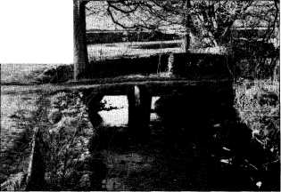
J1995p20_25_files/tmpE8C-1.jpg
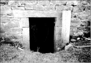
Staggarth showing old lintel (seen vertically on right of door) reused in door jamb. PhotoŚMaureen Ellis.

J1995p20_25_files/tmpE8C-2.jpg
Clapper Bridge near Austwick. PhotoŚMaureen Ellis.
J1995p20_25_files/tmpE8C-3.jpg
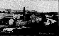
Entry to water wheel housing Runley Bridge mill. PhotoŚMaureen Ellis.

J1995p20_25_files/tmpE8C-4.jpg
Fungi. Illustration by Veronica Kelly.
J1995p20_25_files/tmpE8C-5.jpg