| JOURNAL 1996 |
| North Craven Heritage Trust |
The plan of the poem, written mostly in ten-syllable rhyming couplets, was firstly to present an ascent of "Ingleborough's mount", and to report what can be seen of "the environs". The summit of Ingleborough is, of course, not a peak but a plateau—some three quarters of a mile in circumference, and, just as the distinctive summit can be recognised from many and distant viewpoints, so it commands extensive and varied panoramas in all directions. Dixon's second objective was then "to find Wenning's spring" and to "explore its course", which he describes in some detail and picturesque language, as it passes by "principal places" through the communities of Clapham, Keasden, Mewith, High and Low Bentham, Wennington, Tatham and Wray, on its way to Hornby, where the Wenning runs into the Lune.
Over 200 years later, it has seemed a natural and appropriate tribute, both to Thomas Dixon and to his territory, to follow more or less in his footsteps, to see as much as possible of what he saw on that occasion, as well as to become aware of what he did not see, and to savour his observations and reflections on places and persons. Dixon thought of his ascent of Ingleborough as part of the traditional Mayday ceremonies, for it took place on "the first of blooming May", when "Immense the prospect, keen the nipping air" (line 11). The route along the Wenning described at times follows the river bank closely; at times it passes over raised ground which often gives a more open panorama over the river valley and the surrounding fells. When he wrote "The vale of Wenning I resolved to tread" (line 5) we are reminded that he proposed to carry out his exploration as a pedestrian—which surely gives him some status among all the dalesmen, fellsmen and walkers of the present day.
In May 1995, groups of walkers from Bentham and other communities along the Wenning had the idea of tracing Dixon's routes and verifying his observation, from the summit of Ingleborough down and along the whole course of "the winding Wenning". To emphasise that this was proposed not so much as a performance event, but as an opportunity to observe, interpret and reflect, the event was divided into three stages, each to be done on a different day. The principal purpose of this article is to record the routes followed on those days. It is not claimed as an authoritative itinerary, for various alternatives are possible, and as ever the O S Pathfinder maps, as indicated, should always be on hand.
Stage I: Clapham-Ingleborough-Clapham (circular) Map: OS Outdoor Leisure 2, Yorkshire Dales (Western Area)
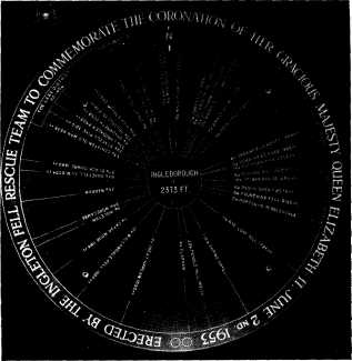
Although Dixon mentioned his intention to "trace the radiant rambler to its head" (line 6), the poem opens with his arrival at the summit and we are at liberty to speculate which route he used. Our decision was that he would very possibly have followed the fell path from Newby Cote, and we approached this along the scenic Old Road from the head of Clapham village. There we turned right, up past these historic buildings, on the track to the Fell Gate (now provided with a substantial ladder stile!). Thereafter we followed the grassy track on a gentle grathent upwards, passing many interesting natural and man-made features towards the low conical summit of Little Ingleborough, especially the curious way-marker of Harry Horse Stone. We joined the main south-north ridge, leading towards the summit massif, where the main path climbs up at a moderate grathent along the eastern side. Once on the plateau edge, we denied ourselves the satisfaction of rushing straight to the central shelter, and made a leisurely anticlockwise circuit of the verges, to inspect the ancient man-made relics there, and to look out in all directions to see what Dixon, and we ourselves, could make out of the "environs". We were fortunate that visibility was good, so that there were eminencies for us, north, west, south and east to identify. Finally, we moved in to the shelter wall, especially to consult the 1953 Coronation direction indicator and take a few photos for record purposes. We viewed the remains of Hornby Roughsedge's hospice and speculated on why it had not survived longer than it did.
Our descent was in no way an anticlimax. First we had to locate "Wenning's spring", the highest of the several sources of the Wenning. Our leader led us to the area below Swinge Tail, at the north-eastern corner of the summit, where the infant spring oozes out through the peat. There is not much difficulty in identifying it, as it can be seen running down, being continually augmented by other streams, to form Fell Beck which carries on above ground until it reaches the great chasm of Gaping Gill, of which Dixon was well aware. At Gaping Gill, the infant Wenning, In Dixon's words "Drops down a pitfall, through a mountain dives", while creatures of the surface follow its course above ground through the great dry gorge of Trow Gill, to meet it again at Beck Head, just above Ingleborough Cave. Here the stream becomes Clapham Beck, as it flows along past Clapdale Drive, and modern walkers have to decide whether to keep to the higher track past Clapdale, or follow the beck through the woods to admire the lake and the exotic trees and shrubs introduced by the Farrer family. At the head of the village just past the church, we made a point of following the path beside the beck, passing the site of Our Lady's Well, and the ancient packhorse Brocken Bridge down to the central Cross, wondering what the banks were like in the earlier days. So ended Day 1.
Stage II: Clapham-Bentham (linear)
Map: OS Pathfinder, 650 (High Bentham and
Clapham)
Several days later the group, with a slightly different composition, reassembled at Clapham Cross. From the New Inn corner we followed the beck-side track on the left of the stream down past the school, along the Green, to find the unusual Mafeking footbridge. This leads over the beck to the welcome underpass below the busy main road (A65), which comes out at the beginning of Station Road. About 300 yards along this, we branched left on the farm track leading to Crina Bottom. We passed the farm on the left, climbed the slope alongside the plantation, and dropped down to the water course below. This is the first meeting with the Wenning ("The Dark River"), which has taken this name a little to the east, where Clapham Beck is joined by others, Austwick, Fen, and Kettles Becks, but where there is at present no right of way. Here the Wenning has to be crossed by a set of fairly good stepping stones - it is expected that the earlier footbridge will soon be replaced. The route continued on, up the rough fell, to Clapham Moor Bridge, which took us across the Leeds to Lancaster railway line on to the Eldroth road. We turned right, and followed the road beside the embankment down to Wenning Bank Bridge, noting the modest Clapham viaduct on the right. Directly opposite, on the south side of the bridge, we entered on the line of field paths westwards, up through Giffords and along to Wenningside (by now the name Wenning is well established!). On our left was Wenning-Hippins, and to the right the elevated Hazel Hall, both mentioned by Dixon. We followed the track towards Clapham Woods, but turned to the right on the path down to Skew footbridge and the area of Skew, where Dixon had spent a good deal of time. This was our lunch stop, after which we crossed the river and the railway, and began on an extended arc of field paths, passing by Lower Hardacre, Green Hill, Old Butt, Chesters, Meregill, and Waterscale (a topographical poem indeed!), to rejoin the Wenning at the handsome Greystonegill road bridge, another favourite resting place. From here there are several routes on to High Bentham, either to the north or the south: we chose the northerly one which passed by Low Linghaw, Ridding Lane, Summerfield, Cowslip Hill, crosses the railway by another pedestrian crossing, runs along past the early Victorian church of St Margaret's, and rejoins the Wenning at the very functional Bentham Bridge. This was the end of stage II.
Stage III: Bentham-Hornby and the Lune/Wenning
Confluence (linear)
Maps: OS Pathfinder 650 & 637 (Bruton & Caton)
Again, after a few days' interval, our group reformed at Bentham Bridge to complete the walk down the Wenning Valley, which was to take us through Low Bentham, Wennington, Tatham, Wray and Hornby. We began by following the riverside path on the south bank, past many unusual features—Dixon refers to Tiphead, Trough Holes, Winder Wheel and Cloudsbank, to emerge at Eskew Lane, quite near the Punch Bowl Hotel. This had been Dixon's home area for many years, and any devotees could spend several hours investigating how it has fared since then; many of the places mentioned by Dixon still exist, and there have been more recent additions.
However, we pressed on down the footpath through John's Bank Wood to cross the County Beck, separating North Yorkshire from Lancashire, on a handsome new footbridge, (recently constructed by masters and pupils from Bentham School). There is then a field path route, which climbs on another extended arc passing through the historic farms of Robert Hall, Greenfold and Blands, with views across to the Ridding and Holmes Farm, mentioned by Dixon, and gradually coming down to Wennington with its ancient green and more modern railway station. There is a substantial stone bridge here, carrying the B6480 over the Wenning. Dixon devotes some space in his poem to the harrowing collapse of an earlier bridge in a great storm, with the loss of three lives. The river bed below the bridge provides some sights unimagined by the thousands who rush by up above.
Our route onwards took us back to the south side of the Wenning, to follow an interesting and varied line of field paths through Overends, past the former Tatham School, across the area of Tatham Park, to Mealbank, a busy farm above Wray which Dixon knew as Millbank. Now there are frequent glimpses of Hornby Castle, but first we had to drop down and cross Meal Bank Bridge which carries the Hindburn over the B6480 and had to be reconstructed after the famous Wray flood of 1967. At this point the Wenning is across on the north side of the valley, and the waters below the bridge are fed by the Rivers Hindburn and Roeburn, two of the Wenning's most notable tributaries, rising deep within the Forest of Bowland. We passed through the village of Wray, as it was the weekend of their famous festival of scarecrows, and picked up one of the footpaths across the fields directly to Hornby. Hornby Castle, a relatively recent construction on an ancient site, is magnificently set off by the Wenning which circles it on the southern side; the path from Wray converges on the river once more, and the two reach Hornby together at Hornby Bridge. Anyone who has walked the length of the Wenning must linger on Hornby Bridge, and look over the eastern side, and contemplate the majestic, peat-stained, flow of water coming over the curved weir, and recall all the places from which it has "sprung".
This was not our journey's end, for we had to cross the road, to find the riverside footpath along Wenning's northern bank, for the shortest mile down to the Lune confluence, and to test our knowledge of the varieties of waterfowl which usually abound in this area. Reaching the confluence, one just has to linger around for a while. The return to Hornby can well be back on the same route, for the view of Hornby, the Castle and Church against the wooded background, with a possible hint of Ingleborough in the far distance, is a worthy souvenir.
Whether Thomas Dixon, yeoman of Low Bentham, ever received any thanks or appreciation for his poem in his own day, we have so far no evidence. However, at the conclusion of these three walks, we should have been happy to meet him and convey our gratitude for his help in learning to see Ingleborough and its environs including the "vale of Wenning", in their totality, their unity and their beauty.
Another year, we shall perhaps attempt this walk in the reverse direction and really "trace the radiant rambler to its head".
For details ask at Bentham Tourist Information or write to the editor of this journal.
The walks leaders in 1995 were: Stage I—Frank Royston; Stage II—George & Deborah Pickett; Stage III—Len Moody.
References: 1. The full title of the original is : A Description of the Environs of Ingleborough and Principal Places on the Banks of the River Wenning:
attempted by Thomas Dixon, of Bentham; Formerly belonging to the Royal Regiment of Horse Guards. Kendal: Printed for the author by James Ashburner, MDCCLXXXI. 2. The new edition, with the abbreviated title of Ingleborough and the Wenning Valley (1994) is printed by Mewith Publications, Bentham Footpath Group, Slaidburn Road, Bentham, via Lancaster LA2 7DL.

J1996p10_19_files/tmp389-9.jpg
We are indebted to Mr Frank Royston, of Ingleton
Fell Rescue Team, for providing this print of a photograph taken at the
inauguration.