| JOURNAL 1996 |
| North Craven Heritage Trust |
5 February 1995 Leaders - Keith & Olwyn Bolger Meeting Place - Giggleswick Church
The first walk of the season must always pose a weather question. This year February Fill-Dyke had lived up to its name, with widespread flooding during the previous week. Prudence required us to stay firmly on the limestone, and apart from two or three muddy gateways we managed to keep our feet dry.
Twelve members and friends left Giggleswick Church to walk up the Mains and along the lane past Woodlands, around the edge of Lord's Wood and out onto "the Scars". This sudden emergence into the open spaces always fills the lungs and lightens the step, but the stiff climb to the lip of the quarry tends to reduce that feeling quite quickly. Once there, however, and after following the marker posts at some little distance from the quarry's edge around to the old drovers' way, the going is even and conversation flowed once more.
It is, in fact, a delightful grassy path which mounts quite gently along the side of Giggleswick Scar past several small caves to the top of Buckhaw Brow. The fields below on the left are on the wet, acid side of the fault line along which we walked. A few days previously the lowest field of the golf course had been completely under water just as it had been in its former role as Giggleswick Tarn, and the Ribble Valley beyond was a shining lake. We could still see remnants of the floods glistening into the distance.
We joined the footpath to Feizor and crossed broad green fields with fine open views of the Scars with Ingleborough beyond and a glimpse of the Lakeland hills in the far distance. Before reaching the village we doubled back to the right on the track to Stackhouse, bearing right all the time until, after passing through a gap between rocks, the path started to descend into the Ribble Valley with Pen-y-Ghent looming solidly to the left and the fantastic limestone skyline above Settle on the right.
From Stackhouse we followed the road to a stile just below the village where we took the field path back to the Mains and Giggleswick, after just two and a half hours of very pleasant walking.
Phyllis Houlton.
5 March 1995 Leader - Brenda Capstick Meeting Place - Ingleton Car Park
When reconnoitring the walk the previous week there had been snow on the ground but this had all melted the day of the walk and we managed a quick tour of industrial Ingleton and some fell walking despite mud and sleet.
Starting at the Community Centre, we walked across the road and down the bank to the Bottoms under the viaduct built cl860 for the Midland Railway but which did not link up with the station for the rival LNWR on the Thornton side of the valley so that initially passengers had to walk across it. We passed the junction of the rivers of the Waterfalls walk which form the River Greta and then the old tannery (now turned into three residences) to the bridge noting its 18th century shape under the modern roadway and passing a house with a datestone of 1668. Following the river up stream we noted the cl800 foundations of the piers for the aqueduct which carried the water from the old mill race across the river to the wheelhouse of the cotton mill on the west side. Still remaining is Bridge End Guesthouse formerly the millowners house with a handsome staircase window rising the full height of the house.
Passing the open air swimming pool which has recently celebrated its Diamond Jubilee and which lies more or less on the site of the upper mill, we climbed up the hill and along to the old limestone quarries facing each other across the valley, noting the remains of the kiln, earlier but smaller than the one at Langcliffe, across the river. We did not go far enough to look at the earlier quarries further upriver which produced the characteristic Ingleton green slate. On our way up to Fell Lane and the route up Ingleborough, we passed an early lime kiln and the line of the old mineral railway which brought stone from the old "granite" quarry near White Scar Caves down to Ingleton station. We turned right before reaching the open fell and the stiff climb up the mountain, and some of us made out the pillars of the Rope incline at the end of the mineral track. Cutting across the fields to Slatenber we walked down the old Clapham road, the original line of the Keighley-Kendal turnpike before it was altered to cross Bentham Moor. We picked up the line of the mineral railway incline as it ran under the road just below Yarlsber and came back into Ingleton, passing the 19th century police station with its magistrate's court on the first floor, and further old houses and datestones in High Street and Back Gate.
Brenda Capstick.
2 April 1995 Leader - Lesley Todd Meeting Place - Austwick Village Green
The walk started up Townhead Lane to the junction with Thwaite Lane. Here we turned left towards Clapham and almost immediately climbed a stile into a field named Thwaite and walked up to a stile beside Nappa Scar. Leaving the Norber erratic boulders to the right we walked northwards to a high stile at the junction of two walls. Here we followed a rather erratic course, trying to avoid too much limestone pavement until we reached a stile where the track up Long Lane turned eastwards towards Sulber gate. We should have expected a very good view of Ingleborough ahead but surprisingly there was only a wall of mist.
We followed the track back past Long Lane and down a little gully to come out at the foot of Trow Gill. Here we followed the track down beside Ingleborough Cave, noting the ram which pumps water from the stream up to Clapdale Farm. We continued on the lower level and entered the grounds of Ingleborough Hall following the carriage drive beside the lake. Here we noted the rhododendrons growing on the far side of the lake on a patch of acid soil. These were planted by Reginald Farrer, who took a boat on the lake, replaced the shot in his cartridges with seeds and fired them into the crevices of the cliff.
We left the grounds beside the saw mill which from 1890 was driven by an early form of turbo generator allowing the houses in the village to have electricity long before other villages in the area. In the village we crossed the stream and passed the Church, following the path under two tunnels formed by the carriage drive in the grounds of the Hall. We followed the path up hill to the foot of Long Lane and along Thwaite Lane ending the walk as we had begun, by descending Townhead Lane.
Lesley Todd.
7 May 1995 Leader - John Chapman Meeting Place - Langscar Gate, Malham Tarn
The walk started with a short diversion southwards up onto Ewe Moor. Much of the remarkable limestone landscape extending from Malham Tarn to Malham Cove can be seen from here. A steep descent eastwards from Ewe Moor took us down to the limestone pavement above the Cove. Gryke-hopping from clint to clint to cross the pavement, we continued on upwards, skirting Sheriff Hill and over the Malham Rakes road to descend to Grey Gill (unnamed on most maps). A rough track up this small and little-frequented side valley allows access eastwards from its higher reaches onto New Close Knotts. The southern tip of the promontory provided the highlight of the walk�an impressive view looking steeply down to Gordale Scar. Retracing our steps to the limestone pavement above the Cove, we returned along the steep-sided Watlowes valley (originally eroded by ice-age glacial meltwater but now a dry valley). A final steep ascent up a rocky staircase led us back to Langscar.
John Chapman.
4 June 1995 Leaders - Joe & Mary Wilson Meeting Place - Tosside
The purpose of the walk was to see sections of the railway route which ran from a depot just below the chapel west of Tosside, to the construction site of the dam which was built across the river Hodder from 1921-1932, to form Stocks reservoir, originally supplying water to the Fylde district of Lancashire. Various supplies were brought to Long Preston station and delivered to Tosside by road.
Our first stop was to look at the sidings of the Tosside depot. We could see the slight embankment heading towards what is now Gisburn Forest.
We drove westward to the Crossroads, then north until we reached Dale Head Church, which was built using stone from the original church at Stocks-in-Bowland, though the church's actual site was not flooded. Bodies were exhumed and re-interred in the church yard.After parking our cars in the park at Dale Head, near the site of the old Church, Vicarage and School, we retraced our steps until we turned left onto a track leading us into the forest. Much of it has been felled in recent years and replanting has taken place.
On the left hand side was a clump of sycamore trees, usually indicating a habitation. On climbing up to them we saw the fallen ruins of Cocklick House, where many workmen were housed in the early days of the building the dam, both in the house and in the barn. It seems they were also housed in other farmsteads, until the building of Hollins village near the dam site.
On going round the bend we were able to look down on the reservoir itself, which will soon be hidden from view by the growth of the new trees. A little further on we could just distinguish the route of the railway running on the right down towards Bottoms Beck, one of the feeders of the reservoir.
With a deviation to the right between fully-grown Sitka spruce, under which no vegetation grows due to lack of light, we came to a clearing on the beck side with a small building, marked on the maps as a water gauge house presumably measuring water flow down the stream.
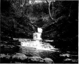
Some of us crossed the stream and made our way through blackthorn bushes to see a series of small waterfalls over dipping rock strata standing on top of level strata, a spot where dippers can be seen. This part of the Forest has not been planted but was covered with varied deciduous trees and undergrowth of bluebells, stitchwort etc. on our visit.
On returning to our original route we turned right on to another track (the line of the railway) which led into a cutting used as a quarry (Greenfold quarry) providing stone for the Long Preston-Tosside road, railway ballast etc. On the right hand side was an embankment rising up to the site of a crusher. This embankment was probably also used for loading trucks.
The line of the railway was followed upstream. On the opposite bank was the clearing of Hesbert Hall Farm.
We could see the route of the track emerging from the forest and running across the fields till it came down to the stream and we saw remains of the bridge supports which carried the track across the beck to what was known as Hesbert Junction.
From there we followed forest tracks higher up the hill, seeing views of surrounding countryside, which will very soon not be seen again for about 25-30 years when the trees are felled again.
Heavy rain fell and almost everyone scurried back to the car park.
Along the route we had seen various flowers including common twayblade, globe flower and tuberous comfrey.
Probably one of the best and most instructive walks we have ever had, unexpected in that we'd expected a botanical walk and it turned out to be factual and historical of the railway involved in the building of Stocks Reservoir (Phyllis Houlton) with rare plants thrown in!!
Joe & Mavis Wilson.
2 July 1995 Leader - Tony Smartt Meeting Place - Helwith Bridge
On a pleasant sunny day with a light breeze, a gathering of eight set out up Long Lane. The view across the valley showed a cross section of the geology of the area in the quarried hillsides opposite including the unconformity behind the Foredale Cottages.
We turned back when we reached Churn Milk Hole, from where we had a close enough view of Pen y Ghent to satisfy most of those present.
The return walk passed the Dub Cote Bunk House, Higher Studfold, across the new foot bridge over the river and back to Helwith Bridge car park.
Tony Smartt.
3 Sept. 1995 Leader - Maureen Ellis Meeting Place - Eldroth Parish Hall
The theme was ecumenical, the route was designed to connect the back road from Bentham to Settle with the A65 and back again. In the garden wall of the new house to the left of Eldroth Hall is a stone tablet commemorating the ancient Quaker burial ground (the property is private but the stone can be seen on the right-hand wall some way back from the road).
Luckily, Jill and the late Michael Sykes were on the walk and gave information about both Quakerism and architecture.
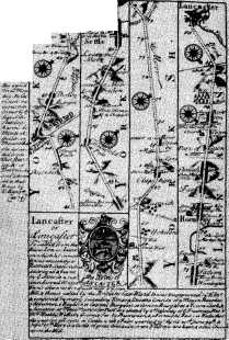
From Eldroth a N E direction was followed using the many step stiles in the wall towards Lawkland Hall in the distance. This famous building is marked on Ogilvy's road map as the York to Lancaster highway passed next to the hall, which was a stronghold of the Catholic faith during the troubled times of the reformation. Mass was celebrated in the private chapel but later a priest was based at a dwelling which is still called Chapel House, which we soon passed. Shortly the footpath turned west towards Bark Head and then north-west towards Ash and over the fields to the A65 where the stile over the wall is completely invisible on the road side. Care must be taken on the short stretch of road from Owlet Hall to the garage where the path leads off southwards through Lawkland Moss and past Middlesber to regain Eldroth eventually. The route is clear on Pathfinder 650 but not so easy to find in some places.
Maureen Ellis.
1 October 1995 Leader - Enid Parker
Meeting Place - Otterburn Beck Bridge
Unlike last year, autumn provided clear weather with good views to Pendle hill as we reached our highest point after leaving Orms Gill farm, our route is well documented in the 1995 Journal. Considerable interest was again shown in discussing the lime kiln adjacent to the farm. Otterburn must surely have been the breeding ground of otters in the past. Thomas Dixon (see Len Moody's article) refers to them in Austwick beck. It is possible that members of the Craven Conservation Group have information about the past natural history of this animal in the Craven district just as they are accumulating sightings of crayfish in the area.
Maureen Ellis.
5 November 1995 Leader - Roy Gudgeon Meeting Place - Lawkland Green House
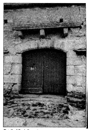
We started by going through the yard of Lawkland Green Farm, across the railway line of the "Little North Western" and through fields until we reached the farm of Accerhill Hall, where we should have had excellent views, but these were limited due to low cloud and haze. From this point we slowly descended through fields and lanes to reach Knott Quarry (formerly Eldroth Knott), from where stone was taken to build both Lawkland Hall and Settle Town Hall. After passing close-by an old packhorse bridge, we made for Lawkland Hall, and before reaching that point were able to see the site of Bark Barn, before having a quick examination of Bank Barn. These two barns were both built in the sixteenth century, but ravages took their toll and Bark Barn was taken down some years ago. However Bank Barn has been recently re-roofed and should last for many years to come. A short walk along the road brought us back to our starting point, having completed about 4 miles. It seemed appropriate, after my election as Chairman to offer refreshments, and tea and cakes were appreciated by all.
Roy Gudgeon.
3 December 1995 Leader - David Johnson
Meeting Place - Stainforth Car Park
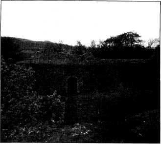
A group met for what could barely be described as a walk. In fact the only walking was across the fields to the Hoffman kiln on the Stainforth-Langcliffe boundary. The emphasis of the afternoon was on exploring the kiln and its environs, to try and make sense of what remained on the site. Torches had been recommended, not because of night walking, but because we were to enter the kiln which is dark at the best of times.
Most of the group braved the walk's first optional obstacle, namely a fence to climb and a bank to slither down, to view at close quarters the Triple Bottle kiln associated with the smaller of the two quarry operations. Most time was spent in and around the actual Hoffman kiln considering its working methods and the problems associated with toiling within it. The kiln's future was discussed, as far as the facts are known.
The day may well have gone down on record as the Trust's shortest walk, but hopefully not its least interesting!
David Johnson.

J1996p20_25_files/tmp43C-2.jpg
Bridge over Terns Beck, Giggleswick. Photo Maureen Ellis.
J1996p20_25_files/tmp43C-3.jpg
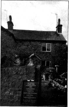
Seed Hill, Ingleton. Photo Maureen Ellis.
J1996p20_25_files/tmp43C-4.jpg
Waterfall on Bottoms Beck in Gisburn Forest. Photo the authors.
J1996p20_25_files/tmp43C-5.jpg
Ogilvy's map from Journal Britanica 1675
naming Lawkland Hall at the bottom of the
third column.
J1996p20_25_files/tmp43C-6.jpg
Detail of Bank Barn, Lawkland. Photo Maureen Ellis
J1996p20_25_files/tmp43C-8.jpg
Hoffman Kiln. Photo Maureen Ellis.
