| JOURNAL 1996 |
| North Craven Heritage Trust |
We live on a green planet, the only one in our solar system capable of maintaining life. How that took place is a separate issue. Having happened though, it can be argued that the planetary life support system is self regulating. Rather than inanimate earth and animate biosphere, this new philosophy (or old one rediscovered), would have it that the whole system, Gaia, or Earth Mother, is really a single organism. Although these days somewhat frowned upon, this way of thinking has perhaps marked the start of a change in the way our environment is seen.
By the first half of the nineteenth century, geologists were beginning to experiment with ways of finding order in seeming chaos. They recognised that strata of the same type could be traced for great distances across the surface of the earth, and invented the great systems for subdividing geological sequences and consequently time. These are still in use today. They recognised for example, that just as the term Carboniferous can be used to describe a characteristic sequence of rocks, whether it be in south Wales or north Yorkshire, the same term has a connotation of time. It must have taken a certain period of time to lay down those sedimentary rocks and even if it was not known how long it had taken, a period of time called the Carboniferous could still be talked about. It took another hundred years to work out just how long the Carboniferous was. The fact that we still use the time scale devised by the early geologists, is to some degree a testament to their powers of observation and reasoning. Although they didn't know about plate tectonics and climate change, they managed to recognise cycles of sedimentary rocks which it turns out are the results of these great underlying processes. Recognising cyclicity was one of the keys to success, and where it could be recognised, the starting points and finishing points of the cycles could be used as natural golden spikes, places in rock and time where you could draw a line and say, "thereafter, a different regime was in place".
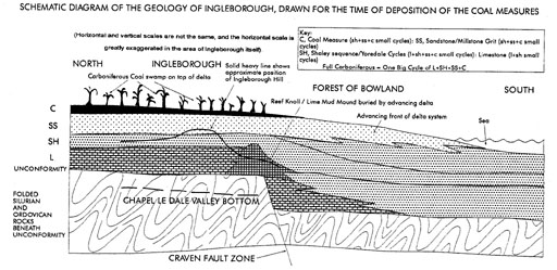
Cyclicity is one of the underlying themes of the geology of Ingleborough Hill. First of all, on a clear day, stand in the fields at Twistleton Scar, and gaze up at Ingleborough. The contrast is striking, between the white limestone forming crags at the bottom of the hill, passing up into a smooth upwardly steepening hill, it culminates in the dark and gritty crags of the summit cliffs. In fact the gritstone crags (millstone grit series) on the summit were once overlain by coal measures, rocks which were deposited right at the end of the Carboniferous whilst the limestones at the bottom of the hill were deposited at the start of the Carboniferous, and were deposited on a previously eroded surface of much older rocks, Ingleborough therefore provides a cross section through almost the entire Carboniferous (see figure). It turns out too, that the progression of rock, from limestone, through gritstone and ending in coal, is like some great musical cadence, one huge cycle which is repeated on a smaller scale many times within the Carboniferous sequence in front of us. Actually the full sequence is really limestone, shale, gritstone (or sandstone)and coal. The smooth part of the hill, between the limestone and the gritstone, although mainly shaley, consists in detail of small cycles which, mirroring the big cycles, pass through limestone, shale, sandstone and coal. The mini-cycles on the back of the big one are called Yoredale cycles and have long captivated the imagination of geologists as to their significance. In detail, the other parts of the overall Carboniferous sequence turn out to show cyclic deposition too, with the basal limestone actually consisting of small, incomplete cycles, of limestone and shale, and the thick summit gritstone and overlying coal measures (eroded here but visible elsewhere) consisting of small, again incomplete, cycles of shale, sandstone/gritstone and coal (with the coals being thickest in the coal measures). It seems then that early in the Carboniferous we see oscillations which repeat only the bottom part of the big cycle, in the middle the small oscillations stand a chance of sampling all the rock types, and as we go upwards only the top part of the cycle is represented.
What though is the cause of this pattern, this repeating earth pulse? During the Carboniferous, northern England lay at tropical latitudes, close to the equator, courtesy of plate tectonics, and rocks can be interpreted in that context. The first order cycle, of the whole Carboniferous sequence, represents a single major global sea level rise, followed by a retreat in sea level. The limestones were deposited when warm tropical seas progressively drowned a flat low-lying coastal plain, turning it into an extensive broad shallow sea. Limestones consist of the skeletons of macroscopic and microscopic organisms which flourish in such warm marine environments, and the remains of corals and sea lilies bear testimony to the macro part of the fauna. The Craven fault system, passing approximately through Ingleton, was active during the Carboniferous resulting in a sudden increase in water depth to the south. Reef knolls, really mounds of Carboniferous lime mud reinforced by the skeletons of marine animals, formed along the line of water depth increase, coincident with the line of this fault system on the sea floor. This in some ways is similar to the way in which the present day Australian barrier reef lies along the line of water depth increase east of Australia. The organisms within reefs are all ultimately dependant upon the photosynthesising activity of marine algae or plankton. If water depths are too deep, not enough light penetrates, and the resulting lack of algae means that the waters are not sufficiently oxygenated or too nutrient rich (full of dead algae), so that the animals which eventually constitute limestones do not form. Passing to the south of the Craven faults, exactly that scenario occurs, (see figure). So the equivalent age rocks to the limestones, deep beneath the Forest of Bowland, are fossil poor and formed from the slow settling of suspended muds from the water column. These rocks, which start life as mudstones, become shales on burial.
Overall, throughout the time of deposition of the thick limestones, coastlines moved progressively further and further north, as global sea levels rose. By the end of limestone deposition, at the time at which the limestone pavements were laid down around Ingleborough, this northwards march ground to a halt, and a huge delta system began to advance southwards from a mountainous proto—Scotland. The sediment flux thrown into the shallow sea buried the submarine plants and animals which had previously formed the limestones, killing them off. The rest of the Carboniferous records the ebbing and flowing of coastlines as subsequent minor sea level rises and coast line advances to the north were repulsed by the ever more forceful delta, which ultimately marched southwards, past Ingleborough and towards Derbyshire. Gradually the shallow sea became filled with sediments, limestone deposition only recurring very occasionally and for short lived episodes during the Yoredale cycles, when particularly strong pulses of sea level rise succeeded in pushing the delta sufficiently far back into Scotland. The shaley parts of each mini cycle represent times when the delta was still relatively far to the north and capable of transporting only minute sediment grains, or muds, into the sea, whilst the sandstones and gritstones represent the more active times of proximal deltaic environments and high energy sediment transport. Ultimately, advances of the delta system reclaimed land from the sea, and the delta tops became colonised by plants of a tropical rainforest which died and themselves became buried, to form coals.
So now we can picture the major Carboniferous rock cycle as a major global sea level rise, followed by the advance of a huge delta system which ultimately reclaimed land from the sea. The small scale pulsation of the rock signal between limestone and coal within this represents an interplay of small scale rises and falls in sea level, with advances and retreats of the delta system. Not only do deltas advance in response to sea level fall, but also as a result of factors like changes in climate over the land areas (more rain results in delta advance). Delta lobes also become inactive, or effectively "switch off" if they advance too far beyond the contemporary shoreline, to be replaced when new lobes to the side of them become active. Given the possible combinations of changes in governing processes, it is remarkable that the deposition which resulted shows the level of regular cyclicity which it does.
That then is the nature of the evidence; perhaps the question is still open. What drove the forces which drove the cycles? Does Gaia really exist and is Ingleborough a pulse recording the heartbeat of a living planet, or is it just a cosy construction, best ignored?
Have a look for yourself and take a walk up Ingleborough. Is the earth talking, or is it just a pile of old stones?
Gill Scott kindly reviewed this article and suggested a number of improvements to it, for which the author is grateful.
J1996p10_19_files/tmp389-5.jpg
SCHEMATIC DIAGRAM OF THE GEOLOGY OF INGLEBOROUGH, DRAWN FOR THE TIME OF DEPOSITION OF THE COAL MEASURES