| JOURNAL 1997 |
| North Craven Heritage Trust |
4th February 1996
Leaders - Keith & Olwen Bolger Meeting Place - Stainforth Car Park
An encouraging number of hardy souls braved the subarctic conditions to enjoy the first outing of the year, crossing the high land behind Stainforth known as Catrigg. This started by using the stepping stones to reach the village green where we turned right down the back street until we reached a gap between the houses on the left with a signpost and the path to Winskill. This is waymarked with yellow arrows and yellow-topped posts and soon climbs diagonally up the face of Stainforth Scar. The limestone blocks or "Catsteps" which form the path can be slippery, so take care!
The yellow-topped posts led us out over the top of the Scar to a stile into Lower Winskill farmyard which we crossed to enter the lane beyond. Where this reaches the open field we turned left to follow the track to the head of Goat Scar Lane next to the famous Catrigg Force. We turned our backs on the waterfall by going right here and almost straight away forked left by a stile in the wall to cross Catrigg beck at its peaceful pre-fall phase. It was hardly visible through holes in the thick ice. The illusion that we were walking within the Arctic Circle was strengthened by the yard as we came out at the top of the long narrow field onto a tundra-like wilderness where the wind had made sculptured patterns in the snow.
The path here is indistinct, but it heads in a straight line North-east to the far corner of the second field after which it doubles back, joining a much clearer path leading westwards and before long steeply downwards to the confluence of Tongue Gill and Catrigg/Stainforth beck. Another bridge and a track took us up to the Halton Gill road and the car park. K. & O. Bolger.
3rd March 1996
Leaders - Helen & Arthur Lupton Meeting Place - Rome Farm, by permission of Mr James Simpson
(MR SD 791 628)
Rome - Swainstead - Sheep Wash - Low
Bank - Low Folds - Lower Wham - Rome
Setting off southward through Farther Rome, the first hazard we met was
the Cocket Lane crossing. Like so many old routes the lane became a watercourse,
it drains Cocket Moss and the water has deepened it into a gulley, we
cross it with all our dogs and walking sticks, and carried on to pick
up another old road at Swainstead, originally the main route from Slaidburn
leading in to Settle by the ford at Runley Bridge. Turning away from Settle
we followed Swainstead Raike to Lower Sheep Wash, the last half kilometre
of the way is covered in tarmac as it has been incorporated into the much
newer road from Wham to Rathmell. Down the hill towards Upper Sheep Wash
the right of way crosses Rathmell Beck by the packhorse bridge, now bypassed
for farm use by the private roadway.
Avoiding the path running directly from Black Leach to Low Folds (which goes through the garden of Upper Sheep Wash, surely just a neighbourly route and never intended as a right of way) we turned north at the top of the hill and swung round by Low Folds to the top of Cocket Moss. Near Lower Wham we were interested in the field drains, which now form a network of ridges, the drained ground having sunk over the years. Since that Sunday I have been told that the drainage was carried out less than 50 years ago, turning a quaking swamp into grazing land—no wonder the peat shrank as it lost so much water.
And so back to Rome, along the straight track followed by the buried telephone lines, cutting out the sweeping bulge taken by the road. Maureen Ellis. Arthur Lupton.
14th April 1996
Leader - Margaret Crisp Meeting Place - Leek Church
A rather dull Spring day saw a dozen of us set off from Leek Church. The 19th century church, which was destroyed by fire, was able to accommodate all the girls from the Clergy Daughters' School (CDS) at Cowan Bridge. Before that time the older girls had to walk two miles through the fields to Tunstall in all weathers. The school at Cowan Bridge had its first intake of girls in 1824—the fees were Ł14 per annum. The Brontes brought an unfortunate notoriety to the school. Maria and Elizabeth entered in July 1824 and 8 year old Charlotte and 6 year old Emily followed in the Autumn. The founder, William Cams Wilson, was represented by Mr Brocklehurst in "Jane Eyre", and this together with the descriptions of CDS in Mrs Gaskell's "Life of Charlotte Bronte" did little to enhance the school's reputation. The school was moved to new premises in Casterton in 1832.
From Cowan Bridge our route took us to the hamlet of Overtown which lies on the Roman Road to Ribchester and which we followed for three-quarters of a mile. Signs of Spring were all around us, new lambs, bird song, spring flowers and a glimpse of a distant herd of deer.
Tunstall Church has a long and fascinating history and is full of interest. The Romans passed through the parish in 72 AD and there is a fragment of a Roman votive stone in the wall near one of the windows. The girls from CDS had to attend two services on Sundays and stayed in the building, eating a cold lunch which they had brought with them. They rested in the room over the porch, part of an alteration to the gallery in 1818. The gallery was removed in 1847.
The return journey to Leek through fields and along quiet lanes afforded beautiful views of Brownthwaite, Casterton and Barbon fells.
Margaret Crisp.
12th May 1996
Leader - John Chapman
Meeting Place - Crummackdale, Austwick
The walk started about one and a half miles from Austwick at a point in Crummack Lane where there is sufficient space to leave a few cars (they cannot be left at Crummack farm higher up the dale). From here a grassy track ascends roughly NE across the fields of the farm, finally crossing a footbridge over the Austwick Beck to join the upper part of Moughton Lane. According to David Johnson, this is an ancient "occupation road" (a walled track through fields leading up to higher open pasture land beyond). The scenery as one walks up the lane becomes increasingly impressive in all directions with Moughton to the right, the abrupt edge of Capple Bank ahead and extensive views looking back down the dale towards Austwick and beyond. The dale also has much to offer to those interested in geology. Horizontal beds of limestone can be seen overlying sloping beds of much older rocks and slates. Near the top of the lane, on the slopes of Moughton to the right, is a hollow identified on the map as the "Moughton Whetstone Hole". Here we found fragments of the strangely banded rock. Mineralogists have yet to agree on how the alternating purple and green bands were formed.
At the top of the dale there is an abrupt change in scenery with a broad expanse of limestone pavement extending behind the steep edge of Capple Bank. Although one can walk along the edge past the cairn, this involves some gryke-hopping from clint to clint and it is easier (although less spectacular) to follow the track going N and then NW to Thieves Moss, once, it is reputed, the haunt of thieves and highwaymen. This track by-passes Beggar's Stile and takes one to Sulber Gate.
The original intention had been to return via Beggar's Stile, descending southwards from there down the dale past Crummack farm and back to the starting point. But the weather was fine, the views were magnificent, and Michael Sykes, who knew the dale better than anyone else, suggested a different route. Alas this was the last time many of us walked with Michael. He died seven weeks later. (See last year's journal). So, from Sulber Gate, instead of losing height we kept to the broad path going roughly SW and then to the grassy slopes above Crummack farm. Instead of descending towards the farm we carried on southwards along a stone track (not marked on the map) on a ledge immediately above the fields going steeply down into the dale. A stile over the left-hand wall led to a descent down the eastern flank of Norber to Crummack Lane.
John Chapman.
2nd June 1996
Leader - David Johnson
Meeting Place - Malham Water Sinks
The underlying motive for this walk was to explore the area between Malham Tarn and Malham Cove, with a particular emphasis on identifying and comparing a small selection of the area's vast treasure of archaeological remains.
Much of Prior Rakes and Malham Lings has been entered into a Countryside Stewardship agreement which guarantees, for the scheme's ten years of existence, open access for the public. The second half of the walk concentrated on this Access Area, looking at the distinguishing features of a linear settlement site, ascribed to the Iron Age; two medieval, possibly Norse, house sites; and an extensive and well documented monastic site by Broad Scars.
The earlier section of the walk consisted of a triangular route from Water Sinks past Locks Scar, Dean Scar and Comb Scar. En route a small, probably Iron Age, site was considered and then contrasted with what is most likely a Bronze Age site.
Archaeology aside, the afternoon offered a feast of limestone pavements, views of the tarn and surrounding hills... and a sense of peace and solitude in the midst of Malham's weekend visitors.
David Johnson.
7th July 1996
Leader - Enid Parker Meeting Place - Airton Green
A clear sunny afternoon, a dozen members met at Airton. The village was very quiet and peaceful. It was hard to imagine the daily clatter of clogs here in years gone by, as the operatives walked down to the cotton mill by the bridge.
We left the village by the Hellifield Road and took the farm lane to Kirk Syke. Following the track through the pastures, we reached Bell Busk. Bell Busk, like Airton, was a mill village a century ago—but these were silk mills.
We turned left along the road and crossed the Otterburn Beck again just before its confluence with the Aire. To our right was the railway. Old Bell Busk Station was the centre of activity for local farmers from Malhamdale, when milk was brought in churns to be transported to Leeds on the early morning milk train. There were many races along the narrow lanes to show the paces of the Dales Galloway pulling traps and milk floats. There was also a wagonette service carrying tourists from the train up to Malham.
We turned off the lane, across the Aire Bridge onto the Gargrave-Bell Busk track. Taking a field path to our left, we climbed along the edge of an old quarry to the white OS column on the top of Haw Crag. There were wonderful views in every direction. The most distant, we thought, was Winter Hill, near Bolton.
Just beyond the crags, we joined the Pennine Way, and reached the Aire again at a footbridge following the river upstream to Newfield Bridge on the Gargrave-Malham road. A short walk through the fields brought us back to Airton Bridge.
Enid Parker.
1st September 1996
Leader - Hilary Baker
Meeting Place - Long Preston Green
The walk started by taking one of the many lanes from Long Preston leading to Langber Lane. We took the most northerly one hoping the weather had been dry enough to allow us to cross Bookil Gill Beck dryshod. On reaching Langber Lane we turned south and walked down the lane till we saw the gaunt remains of the burnt down Bookilber Barn stark against the sky. Opposite the barn we took the path that led us across the fields towards Crake Moor. Before reaching Crake Moor we turned south again, following the wall which marks the boundary of Long Preston parish until we came to Langber Lane again. We turned north west on Langber Lane to the footpath that goes over Newton Moor and the Waterfall Rock to Little Newton and then followed the track back to the village. Hilary Baker.
6th October 1996
Leader - Harold Foxcroft Meeting Place - Dalesbridge Centre Harden Bridge
What do clapper bridges, early settlements, toll booths and infectious disease hospitals have in common? They all lay on a walk started from the Dalesbridge Outdoor Centre to the west of Austwick. Jon Beavan, Director of the Centre started by explaining the present use of the buildings and indicating how the former Isolation Hospital had been adapted. A brief history of the hospital was given and its antecedents from 1879 onwards, followed by a walk through the grounds to identify the original use of the buildings.
The walk following from there crossed the A65 to meet Austwick Beck at stepping stones which are not generally known to visitors. After crossing the beck by two clapper bridges formed from unusually long 'flags', at a point where the beck actually forms an island, we passed on into Austwick, joining Holm Lane. From here we started along the path which would eventually lead to Clapham. We noted the extensive Field System and the remains of an Early Settlement (period unknown) and then made our way westwards to the original trunk road, with the remains of an old Toll Booth and adjacent Boundary Stone visible.
Again the A65 was crossed and we followed a path towards Waters Farm, crossing Austwick Beck again at an unusual type of bridge for this area, which more closely resembled the Lake District slate bridge. The return to Dalesbridge was via Orcaber Lane.
Over a cup of tea in the former Scarlet Fever Pavilion we were able to study the interior adaptations combining the 90 year old basic fabric with modern design.
Harold Foxcroft.
3rd November 1966
Leader - Maureen Ellis
Meeting Place - Clapham Station Car Park
"The Faraday Walk"
I called this the Faraday Walk because on leaving the station by the Slaidburn road the Faraday families' place of worship, the Sandeman chapel, is on the left hand side of the road and the first goal was Clapham Wood Hall and Keasden, both associated with that family. It is a two hour walk and after crossing the Wenning river take a south westerly direction via the squeeze stile to Giffords, then on to Wenning Side, up the hill and round the barn to the green road leading eventually to Briar Holme Wood. However, we branched off left with our next sighting the copse of Scotch pines on the hillside, through which the route traverses, and then on to Clapham Wood Hall. We were lucky enough to have Ian Woodburn show us a slate, probably from a shippon, with RF (Richard Faraday) engraved on it. This was left by previous owners of the house and may well end up in the Faraday Societies collection.
Several people would have liked to stay talking to Ian who is so knowledgeable but short daylight hours forced us on, to take the Mewith road for a quarter of a mile and then up to The Heigh and Heigh Head (with permission from the owners) and across the moor to Hawskheath. Reference to Philip Rimington's article in this issue will expand on this building. Then it was down the track to Turnerford farm, sharp right over the small wooden bridge and up the hill towards Jack Beck House and Dubsyke. The path is well sign posted on this stretch as there is a newish diversion round Long Bank and up to Watson House with its deer. The last lap is a short distance to the right along the road, north onto the path to Lawsings Plantation, and then left onto the tarmac road beside the railway track to regain Clapham Station.
Reference: Ian Woodburn - "A Common Sort of Farm House"
North Craven Heritage Trust Journal 1994
Maureen Ellis.
1st December 1996 Leader - Jill Sykes Meeting Place - Scar Top, Buckhaw Brow
The December walk is hampered by a shortage of daylight, but 18 members made the most of the two hours available. We walked towards Feizor Thwaite, crowding on top of a Bronze Age barrow, inspecting a more recent small reservoir looking like a sheepfold, and discovering what might have been a dew pond, now drained.
We were shown an ancient boundary wall, denoted by the orthostats (large stones, rounded or pointed tops) at the base of which the dry stone wall was later built.
On the Thwaite we saw three old field kilns, forerunners of the built limekilns we still see (one good, and two ruined examples in the distance), then eastward to a ring-cairn (sometimes called pond cairns, though no water) with a burial cist visible in the centre.
Another quarter mile brought us to the "Apronful of stones" (the devil dropped the stones on his way to the Devil's Bridge at Kirkby Lonsdale). The tumulus is now completely rubbed out except for a perimeter of tumbled wall. This was assumed to be the burial cairn referred to in "The Parish of Giggleswick" by Brayshaw & Robinson, with an illustration from 1784.
Homeward into the wind and rain, we found yet another circle this time a "fairy ring" of fungi—at last something for the botanists.
There is an advantage to the short December walk; failing light didn't hamper our enjoyment of mincepies, tea and good conversation!
Jill Sykes.
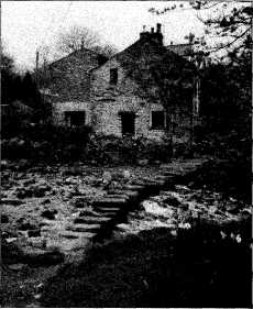
J1997p20_31_files/tmp758-3.jpg
Stepping Stones, Stainforth. Photo Maureen Ellis.
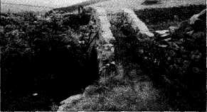
J1997p20_31_files/tmp758-4.jpg
Pack Horse Bridge to Upper Sheep Wash. Photo
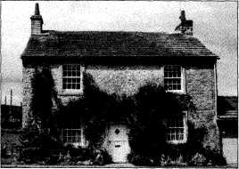
J1997p20_31_files/tmp758-5.jpg
Airton Green. Photo Maureen Ellis.
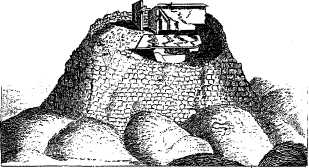
J1997p20_31_files/tmp758-6.jpg
Tumulus at Stackhouse. From the 'Gentleman's Magazine', 1784.