| JOURNAL 1997 |
| North Craven Heritage Trust |
31st May 1996
Leader - Keith Bolger Giggleswick Village Walk
This was the first of a new series of evening walks entitled "Know your area" and was extremely well supported. Our brief was to spend about an hour and a half noting places of interest on the way and finishing in the local hostelry to discuss the evening's tour. In the event it proved rather difficult to keep up even such a slow pace, and we had to miss out a little of the planned route, but it was a beautiful late Spring evening and we enjoyed the pleasant surroundings and each other's company.
The tour started in the church, which is probably the oldest building in the village, with traces of a Norman foundation and much of the present structure dating from the fifteenth century. Members did their own tours of the interior using the guides available to visitors and then we set off on our walkabout, noticing Ivy Fold, once the vicarage, very picturesque with its two lintels dated intriguingly 1669 and 1677. Church Cottages in Church Street are an example of conservation in action, rescued from the threat of demolition and restored to stand for some centuries more. The Victorian Primary School is at the centre of the village in every sense and is where our future history has just begun!
Our route took us via Beck House, Brookside and the "Green" to Castleberg Hospital, built in 1834 as the Workhouse to serve Settle and Giggleswick. We then walked down Buck's Lane to Tems Street, past Armistead House and across the Harrison playing field, following the line of the old Kendal road. In Bankwell Road we admired several fine old houses. Queen's Rock was the ancestral home of the Brayshaws, Bankwell of the Birkbecks and in a previous building, of the Bankes family. Well House was at one time the vicarage, and there are many houses with datestones. The well itself predates them all, and with HolyWell and the Ebbing and Flowing Well probably gave rise to the settlement of Giggleswick in the first place.
We came next to Belle Hill, where Craven Bank, now divided into two dwellings, was the original Hart's Head Hotel. The business moved to the top of the hill when the new road was built in 1753. Sutcliffe House is another notable 17th century building standing at the top of the hill. Past the cottages on "The Flaggs", and the Post Office and village shop, we came to the Market Cross and the remains of the village stocks. The head of the cross is said to be 14th century and there are various stories of its chequered history.
We were now literally on the doorstep of the Black Horse Hotel, another very old building, possibly with religious origins, but on this occasion serving its age-old function as a very satisfactory social centre.
Keith Bolger.
24th June 1966
Leader - Len Moody Bentham Town Walk
The route began at Linghow Cross, for an overview, then dropped down by car to Lairgill car park; then through the areas of Mount Pleasant and Station Road, passing Grove Hill, the Methodist Chapel, St Margaret's Church and Geo Angus Fire-Armour Ltd Just after the railway bridge, we turned right into Wenning Avenue, passing the new housing on the old mill site, and then the right-of-way through the northern part of Riverside Caravan Park to cross the railway line and then up Duke Street to Main street at the Bentham Halls (old and new). The tour continued back along Main Street, with its assortment of former farms (Bigber, and Parkinson's), date-stoned cottages, the Youth Centre (formerly the Friends Meeting House), to the central Cross, with our refreshment target The Coach House (formerly the Brown Cow)!
Len Moody.
22nd July 1996
Leader - Hilary Baker Long Preston Village Walk
On a rather indifferent July evening a group of about 40 met on Long Preston's Maypole Green. First we looked at the milestone there and on reading the mileage to Skipton and to Settle decided their miles must have been longer than ours! Perhaps it could have been moved from another site. Over the road we saw the water fountain dated 1869 commemorating the Holgate family who had water piped to the village.
After looking at several of the older cottages we went down to the Long Preston Beck near Mill Bridge and saw what we assumed was the course of the old mill leet presumably to the old corn mill that was swept away in the flood of 1881. There was also a cotton mill in the vicinity. We saw evidence that there was once a ford where the "fairly new" bridge now carries the A65 across the beck; the houses on either side of the bridge are at a much lower level than the existing bridge and slope down to the water.
Time did not permit a visit but we looked across to the Almshouses which were founded in 1615 by James Knowles, a London merchant who was a native of Long Preston. They used to house "10 poor persons" (men or women) who had to be natives of the parish. They were rebuilt in 1858 and have since been modernised and enlarged, housing fewer occupants. The old chapel bell from the Almhouses has a permanent resting place in St Mary's church.
We then continued our walk to the church first looking at the old sundial, near the porch door, which is dated 1667 possibly put there to commemorate the restoration of the monarchy, or, another authority suggests, to commemorate the plague which is said to have reached Long Preston. The church itself was built on the site of a much older, possibly Saxon, church. There was certainly a church in 1086 as it was mentioned in the Domesday Book. We were particularly interested in the window—the East window—which is the work of Capronnier of Brussels and is dated 1858, and the vestry window of plain glass incorporating fragments of stained glass heraldic shields dating from the medieval period which were in the original East window.
We then turned our attention to the schools in the village. The first school was where Ward's workshop is, and is dated 1640 (a modern stone) but you can still see a bell on top. The second school was on the lane between the church and the present school and was endowed by a Miss Isabella Hall in 1819—it has an unusual tracery window. The present school was opened in 1898.
After looking at several more of the older cottages and speculating, or in some cases learning, a little of their earlier uses, for example the police house and lock up, the church meeting house (denomination unknown), the old weaving cottages, the cottage with the external chimney and the one with the unusual sideways-sliding sash windows, we arrived back on the Green just in time, as the heavens then opened and scattered us all to home or the Maypole.
Hilary Baker.
20th August 1996
Leader - Chris Ellis Langcliffe Village Walk
The village has probably moved about 300 yards south from the original settlement and is fairly unusual in owning the village green—made up from "manorial waste land".
We started at the school, built in 1825 and used for church services until the magnificent church was built in 1851 largely through the generosity of a member of the Paley family. Opposite the church is the Institute built by Hector Christie in 1899 for "men and youths" which created trouble in the politically correct 1990's!
As the green was owned by the village, buildings which were to the advantage of the village were allowed to be erected—hence the cottages and Methodist Chapel. An early type gaslight bracket was spotted by Hall Cottage, formerly the Hall farm, gas was supplied from Christie's Mill.
The large building at the south end of the Green was the workhouse cl809 and is now houses. The fountain was one source of water before mains, with the War Memorial erected in 1920. The group of houses behind the fountain and tree were farms both with sons who were senior wranglers at Cambridge in the 17th century.
It was then down New Street past quarry and millworkers cottages, including the home of John Delaney, to Holme Head, better known as "The Locks". This area dates from a mill in monastic times with the dam leading down to the High or Christie's Mill. This modern mill was built by the Claytons with advice from Arkwright in 1784.
From here we took the old workers' path over the railway to Langcliffe Hall built in 1602 on the remains of a Sawley Abbey grange. By kind permission of Robert Bell we had a close look at the exterior, especially the west front which is still original. Unfortunately failing light prevented us from going round the gardens so we retired to Bowerley (19th century), now providing a welcome drink.
Chris Ellis.
Langcliffe Green. Photo Maureen Ellis.

J1997p20_31_files/tmp758-7.jpg
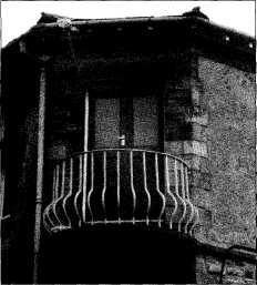
Festival of Britain Logo at Castleberg Hospital. Photo Maureen Ellis.
J1997p20_31_files/tmp758-8.jpg
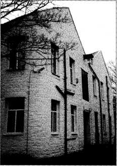
Station Road, High Bentham. Photo Maureen
Ellis.
J1997p20_31_files/tmp758-9.jpg
Long Preston, back of Magna Print premises.
Photo Maureen Ellis.
J1997p20_31_files/tmp758-10.jpg
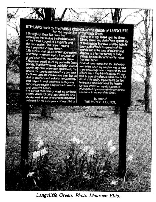
Notice board in Langcliffe