
J1998p10_19_files/tmpA57-12.jpg
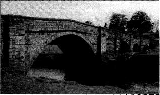
Settle Upper Reservoir, 1904 Photo: T A Foxcroft
2nd February 1997
|
Leader - Maureen Ellis Meeting Place - Eldroth Village Hall From Eldroth we took a southerly direction under the railway line with the delightful Black Bank Syke in the dip to our right as we reached Black Bank itself. This is a complex of farm buildings, the original 18th Century house having been rebuilt in the 1950s. A short left turn up the tarmac road and we were once again on a footpath, now going towards Howith, then round the house and through the squeeze stile in the direction of Butterfield Gap, which was just visible on the skyline. Here we made for Chapman Bank, our ultimate goal being Israel. Farms on the high moorside with names such as Rome, Jerusalem and Israel are said to be associated with the Quakers. A previous owner of the cottage at Israel said there was a peat loft and barn and a fireplace appropriately shaped to burn peat. After Israel the route went almost down to the wooded valley in a northerly direction past East Kettlesbeck (yes the path does go right through the garden and is well signed) and High Kettlesbeck. Then it's along Craggdale skirting New Kettlesbeck (not being tempted by the substantial bridge to the right). The path again goes through a garden at Cragg Bank where there is a warning to take care as the railway line is about to be crossed, and we were lucky enough to see the 4.10 pm to Bentham go by. Then it was back to the road and a right turn back to Eldroth. As we walked to the cars we passed another stile in the direction we'd come and I made a mental note to explore that path at some later date as an alternative way down. Maureen Ellis 2nd March 1997 Leader - Harold Foxcroft Meeting Place - Greenfoot Car Park, Settle Car travellers were shuttled from Greenfoot Car Park to arrive at the Pound on Mitchell Lane and there to join local walkers who had reached the same place on foot. The walk's purpose - conducted, fortunately, in dry weather but bedevilled by an energy-sapping wind after much recent rain - was to examine the changes made to the landscape of this area in the last 150 years. This was done by using a section of an Ordnance Survey map based on a survey in 1847 and comparing it to the same area as depicted on a modern OS Outdoor Leisure map. From a point near Peart Crags we were able to note the absence of railways and Giggleswick School Chapel on the older map, but could clearly see the Tannery, Dog Kennel Mill site, and the remains of the many Sandstone Quarries in the area. From here we climbed to cross Dog Tarn to join the many green lanes and walled tracks which intersect in this area. Having walked to Hunter Bark we returned to reach and (for most of us) to cross the Kirkby Malham road. Unfortunately the heavy rains of February had left quite an extensive lagoon across the lane here and some of the party remained at this point until those who were more waterproof walked on to Stockdale Lane, to circle a Roman Fort site - for so it was described on the earlier map - and to see a dewpond which was surplus to requirements in the prevailing conditions. On the return leg of the walk we came down to Settle High Reservoir, whose history was described, supported by some photographs taken during its construction in 1904/5. Harold Foxcroft |
6th April 1997
Leader -Arthur Lupton
Meeting Place - Long Preston, Cow Bridge
Water Features everywhere.
Starting at Cow Bridge, on the road from Long Preston to Wigglesworth, we explored the aqueduct and culvert of the Long Preston Deeps drainage system both upstream and downstream of the bridge, before climbing to a vantage point where we could see the narrows by Arnford. This was the suggested site for the dam that would have impounded water in the proposed Hellifield Reservoir and turned Giggleswick into a lakeside settlement. Unfortunately we had not been given permission to visit this beautiful spot, where the Ribble flows through a narrow Vee cut through the high land on each bank.
Returning to Cow Bridge we drove to Long Preston Station yard via Bendgate Farm, noting a third Water Feature where the Settle branch of the Leeds and Liverpool Canal would have crossed the road on the 147-metre contour.
Our next objective was Long Preston's own reservoir, reached by New House Lane and Holme Bridge. The village still has its independent supply of water, drawn from boreholes close to the reservoir in the valley bottom. Climbing past the reservoir, our route joined Langber Lane by the ruins of Bookilber Barn, and descended Long Preston Beck again along its extraordinary gorge, resembling the eroded path of a remote geological disaster.
So after proposed reservoir and surviving reservoir, canal, flood relief and natural flood we returned to the village. Walking along Back Lane to the station yard we glanced over me wall at our last Water Feature of the day as we passed the village sewage works.
Arthur Lupton
11th May 1997
Leader - Brenda Capstick
Meeting Place - Kingsdale Road
Brenda took us for what turned out to be her last walk with the Trust, starting on the Kingsdale Road beyond Thornton in Lonsdale, climbing onto the Turbary Road (a track) on the eastern slope of Gragareth.
After an early cold blustery shower, the weather became kinder, allowing many of us to explore a small underground water passage near Rowten Pot. We emerged safely at the other end, a little welter for the experience.
At the northern end of the valley we dropped down the slope to Yordas Cave, large enough for us all to explore together.
As we were running out of time, the walk ended with a shuttle of cars down the valley, with some of us finishing on a newly made path by the river, passing near to the prehistoric "apronful of stones", consolidated recently after river erosion, to Braida Garth.
Brenda told us about the Turbary Road itself and the peat-cutting rights, but we didn't extend the walk to find the old marker stones that she knew were there.
We shall all miss Brenda very much, together with her wonderful knowledge of the ancient landscape.
Jill Sykes
1st June 1997
Leader - David Johnson Meeting Place - Dry Rigg Quarry
A beautiful sunny, if breezy, day saw two dozen members and friends congregate at the entrance to Dry Rigg Quarry at Helwith Bridge. The walk's theme was to be rocks and quarries: the area has a wealth of both interesting geology, and evidence of past and current quarrying in the form of seven defunct and two operational quarries.
The group first ascended Sunny Bank for an overview of the area's geological structure and to put into perspective the signs of the long dead tectonic forces that have done so much to shape this part of the Dales. The North Craven Fault, intense folding, metamorphism, sea level change, can all be identified within the exposed rocks of Helwith Bridge. We then dropped down into Helwith Bridge quarry to discuss its early importance and to view the water wheel site, and remains of the conveyor system that carried stone across the river to waiting trains.
A walk across the meadows to Studfold followed a discussion of the former stone mill at the bridge itself, and how the building of the railway necessitated not only the re-siting of the bridge but also the permanent diversion of the river. From Studfold the party crossed the Ribble and used the sunken accommodation road to Cragghill Farm, before turning south on the newish path created by the operators of Arcow Quarry.
The site of the old Ribblesdale Limeworks was pointed out, along with an odd snippet or two of its history, before the final leg, sandwiched between quarry spoil from Dry Rigg and Swarth Moor.
The total distance was barely four miles, but the walk and discussion at many spots made it a long, but hopefully enjoyable, afternoon.
David Johnson
6th July 1997
Leader - John Chapman
Meeting Place - Lee Gate Farm, Smearbottoms Lane, Malham.
Those who intend to park at Lee Gate Farm are warned. Don't leave the car in that obvious space in front of the large barn. A herd of cows comes past in mid-afternoon and cows aren't good for wing mirrors. Fortunately Frank Carr, the farmer, had the foresight to tell us. Better, he said, to leave vehicles on the grass a bit further down.
It was a lovely summer day. Our immediate destination was New House Farm on Malham Moor, not much more than half a mile away. Here we were met by Alistair Clunas, the National Trust Head Warden for the Malham Tarn and Upper Wharfedale Estates. As Alistair explained, the 65 acres of New House Farm have recently been acquired by the National Trust in order to preserve its flower-rich hay meadows. For nearly 40 years these meadows were owned and farmed by Mr Walter Umpleby using the traditional harvesting methods of his forefathers, scything and raking the hay by hand when flowering was complete and avoiding chemical fertilisers and modern machinery. This has led to the survival of a remarkable variety of flowering plants and in the words of the National Trust, to meadows of exceptionally high conservation value. Mr Umpleby has now retired but, with the Trust's assistance, their new tenant will continue to farm by the traditional methods. The weather over the previous few weeks had been such that we were rather late for the best of the flowers but the abundance of flora in several of the meadows was still apparent. With larks and curlews circling overhead, it is a wonderful upland place.
From here we continued eastwards down into Cow Gill, crossing Heber Beck spring and up the other side to join the path in a northerly direction to Bordley. That is what it is called on the map, but it's "Bordley Town" on the sign posts, even though, with no church and consisting of little more than a couple of farmhouses and a few farm outbuildings, anything less like a town could hardly be imagined. The sheltered situation and the considerable number of footpaths and bridle ways converging on it do however point to a much larger settlement in earlier times when it provided a grange for Fountains Abbey. A barn has an interesting date stone "CW 1664". (CW, according to David Johnson, was Cuthbert Wade, and the datestone may well have adorned a house.)
From Bordley a broad track in a SE direction leads to Lainger House and the road to Hetton. We walked along this track for about a mile and then (after stopping to contemplate the view of our return route) took an abrupt turn downhill westwards towards Bordley Hall. This description is also misleading as the present farmhouse, built in the 18th century lacks the grandeur expected of a hall. The final part of the walk was uphill northwards to rejoin the path past New House to Lee Gate.
John Chapman
7th September 1997
Leader - Roy Gudgeon Meeting Place - Eldroth Church
Just on twenty members set off to explore unknown parts of Eldroth, which is all encompassed within the Township of Lawkland. After parking our cars at Eldroth Church we passed through fields to reach the immaculate farm of "Lanshaw" which has twice been in the ownership of the Farrer family, but is not now part of that estate. Old records indicate that a farm has been on this site for many centuries. We continued our journey over the railway constructed in 1847/48, passing Low Kettlesbeck to reach the site of Kettlesbeck Mill. All the stones from the building have been taken away, and all that remains are the two small reservoirs, though the track of the old mill race can be seen stretching for over a quarter of a mile to the point where it joins Kettles Beck.
We eventually reached New Kettlesbeck Farm and walked along to Lingthwaite and slowly descended to Eldroth. On the way down we had excellent views of the Three Peaks and the surrounding countryside. A short walk along the quiet road brought us to our starting point, Eldroth Church where we had the opportunity to look around this most picturesque Church. One of the walkers, Tom Grounds, is an organist at Eldroth Church and he gave us all a musical interlude whilst we examined the building which until 1947 doubled as both Church and School. Joining us on this walk was Harry Jackson, who until recently lived all his life at Eldroth and had spent many years at school there. He was able to give many interesting stories of the locality.
Roy Gudgeon
5th October
Leader - Barbara Middleton
Meeting Place - Greenfoot car park, Settle.
The walk continued to Mearbeck and then back over the footbridge through Cleatop Park. This wood is owned by the Yorkshire Dales National Park and contains a variety of trees, woodland plants, birds and in times past badgers. During the 1940s it was a source of fuel.
Twenty three people set off from Settle on a sunny afternoon offering clear and extensive views over Ribblesdale and into Lancashire. We walked along Watery Lane, which is called Brockhole Lane on the map. A stroll round Dog Meadow allotments was included with a look at how the old drainage system provides a water supply for the allotment holders.
At one point Watery Lane is a footpath and a stream in which watercress grows and where children like to play. From the end of Watery Lane field paths were followed to Cleatop Park. There were magnificent views to be enjoyed, the Bowland Hills, Giggleswick Scar, Castlebergh, Pen-y-Ghent and below us the busy A65 and Settle bypass.
After the confines of the trees extensive views emerge along the field paths to Lodge Farm house and a stone circle was identified. Then the route proceeded down and across the fields, where earlier in the year bluebells are plentiful, to join Watery Lane and back to the car park.
Barbara Middleton
2nd November 1997
Leader - Len Moody
Meeting place - The Cross, Clapham
This circular walk was designed, partly, to trace some of the upper reaches of the River Wenning, and partly to inspect recent improvements to Laithbutts Lane by volunteer workers from Bentham School. The earlier part of the walk would also be following the route of the Thomas Dixon Walks, visiting "principal places on the banks of the river Wenning" (1781).
Assembling at the historic Cross at the centre of Clapham village, we took the little-known route southwards by Clapham Green, past the Farrer memorial School, down to the treasured Mafeking Footbridge (shades of Victorian heroism!). This crosses Clapham Beck, and leads immediately to the more modern underpass below the busy A65, something of a novelty to the hundreds (or thousands) who speed along the road at all seasons.
Having surfaced again, we continued southwards towards Clapham Railway station (omitting the exciting diversion to the Clapham Crina Bottom and Clapham Moor, as on reconnaissance the stepping stones were not safe after recent rains). At the Flying Horseshoe we carried on under the Leeds/Morecambe line and over the Wenning Bank Bridge, the first road bridge to cross the infant river, with attractive prospects both up and down stream. Just beyond we took the field path, passing the ancient farm building of Wenning-Hippins, to the more recent buildings of Giffords, and south westerly to Wenningside, an expanding working farm. We continued westwards as far as the curious Keasden Skew Bridge, by which we crossed to the north side of the Wenning, recrossing the railway line at the level-crossing, and on to Lower Hardacres. Here we began circling back north east to High Hazel Hall and Nutta Bridge (a galaxy of place names), and turned north for a short way along the road, to find the public right of way forking off right over Newby Moor, ending up at Newby Hall, and then the model green of Newby village. The shades of night were now falling fast, and we considered it advisable to return to the Bentham road for a speedy conclusion, making a note to include Laithbutts Lane on a future walk.
A homely walk perhaps, not described in any tourist guides, but full of topography and useful in our programme of getting to know the area intimately.
Len Moody
7th December 1997
Leader - Jim Nelson
Meeting Place -Watershed Mill,Settle
The programme of Sunday Walks is headed "Stout footwear, waterproof clothing should be worn". 7th December was no exception as the sky was hung with grey clouds. I wondered how many brave walkers would turn out? Two dozen members and friends assembled for the mill history walk along the Ribble Way. The story of the two fine spinner mills is told in detail in the 1996 Journal, with one mistake. The 700 rpm is a printer's error, and should be 70. At 700 the fly wheel would be right off its bearings!
From there the foot path took us by the mill dam, over the locks bridge to the Stackhouse side of the river, past Johnny Waugh's wood (brother of Ben, founder of NSPCC), to Langcliffe Paper Mill. Here the remains of the old mill race and dam can be seen and what would have been the mill pond in the days of water power.
Robin Hood's Mill (which of course is an underground stream and not a mill) provided a talking point, then to Stainforth Foss and Bridge (National Trust). There is very little to be seen of the cotton mill some 200 yards upstream, but the mill race is clearly visible along the field wall side. The search for mill history in Stainforth village has not proved very fruitful up to the present time but if Sunday the 7th was anything to go by there was a good flow of water to provide power for a mill of the size of the early cotton mills. The site of the mill headrace can be traced and what appears to be a possible tailrace return downstream.
The stepping stones must go back before history and give the name to the village, when the "stanes" were the only fording place, the bridge being built about 150 years ago.
Friends were provided with a little pre-Christmas refreshment at Haywood House on the return to Settle.
Jim Nelson