| JOURNAL 1999 |
| North Craven Heritage Trust |
In this age of the fax, mobile 'phones, video-links etc., it is easy to forget that the word 'communication' meant something vastly different in the distant past. In Roman times routine messages were usually transmitted by army riders or post couriers but for more urgent communications various systems such as signalling by semaphore, heliograph or fire beacons were employed. Signal stations were set up where a long distance line of sight existed; the Craven uplands must have provided many sites for stations to be linked in a large cross-country communications network.
The Romans annexed Brigantia (in which the whole of Craven was included) by a double pronged advance either side of the Pennine chain; from Lincoln in the east and Wroxeter in the west. The need for a means of rapid transmission of commands and reports between the two armies was paramount. Never slow to take up tribal techniques and adapt them to their needs the Romans probably utilised conquered tribal centres with proven signalling techniques to synchronise the two northerly advances.
Once Brigantia was subjugated and York became the northern command headquarters of the legionary armies it became vital for every fort established in the new territory to be in direct communication with York so the network would have been enlarged yet again. Late 1st or early 2nd century forts at Ilkley, Elslack, Bainbridge, Burrow in Lonsdale and Kendal will almost certainly have been linked in a chain. Yet now, nearly two millennia later, there are very few signs of that all important network. Where was it, how did it operate?
A clue lies in the way Roman military surveyors and engineers used fire beacons to lay out their famously straight roads. It is very probable that these roads were superimposed on prehistoric tracks which (as the ley line enthusiast Alfred Watkins suggested) linked tribal centres usually located on high points. By tracing these roads it thus becomes easier to postulate where the numerous signalling stations were located.
The most obvious line from a local point of view is the proven Roman road from Ilkley to Kendal. This road, the equivalent of today's A65, was probably laid down in the early to mid second century to supplement the route across the Aire-Ribble corridor, both roads offering relatively easy ways through the Pennines for infantry and cavalry.
It is logical therefore that a system of signal stations existed through the Craven Gap (Fig 1). Although the Ordnance Survey lists very few known Roman signal stations in Yorkshire (a series of 4th century stone towers along the Yorkshire coast and the classical series found over Stainmore - attributed to Cerealis' annexation of AD 71-74) many will have existed. Yet evidence of them is hard to come by. The problem lies in recognition.
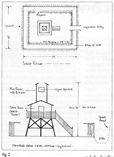
Fire towers in the north (and certainly in the early days of the conquest) tended to be timber structures surrounded by earth ramparts and ditches (Fig 2). The Stainmore series (which could be representative) were rectangular enclosures about 60 by 47 feet and consisted of a ditch inside which was a rampart of turf. Upcast from the ditch formed a mound around the whole. On a rectangular plinth within the defences there would have been a high timber tower with ladder reaching to the fire platform upon which was a brazier.
Margary records an alternative design located near Strageath in Perth and Kinross; a circular turf platform 40 feet in diameter had been excavated from a ditch with a gap and entrance causeway. Within the moated compound were found the socket holes of four massive timber posts which would have supported a high wooden tower 12 feet square.
Locally, research along the Aire-Ribble corridor has pointed to a series of stations handling east-west communications between the forts of Elslack and Ribchester across Mellor Moor. Similarly a fire tower in what was probably a chain covering the Roman 'M6' trunk route through the Lune gorge has been detected by electrical resistivity survey to the rear of Middleton Hall in Lonsdale.
Quite what was the system of signal codes we do not know. Presumably moveable screens would have been used to give intermittent light signals on the same basis that the present day lighthouse emits sporadic pulses. Possibly, on sunny days, heliographs would have replaced the normal incendiary apparatus.
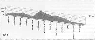
In locating these stations we must rely on conjecture to a large extent yet a plot of the highland contour between the key estuaries of the Lune and the Humber reveals certain significant pointers to the Craven Gap system. (Fig 3).
In his book on "The Craven and NW Highlands" Harry Speight claimed much Roman military activity in the Settle area. He also claimed to have established a clear line of sight from Rawdon Billing on the western fringes of Leeds to Ingleborough. He stated that he saw from that vantage point a bonfire lit on the top of Ingleborough to celebrate Queen Victoria's jubilee.
Before we discuss the role of Ingleborough as a probable pivotal point in a cross country network it is as well to look at lower eminences less prone to being blotted out by mist and rain. From York westwards there are numerous optional high points, the chief of which stands above Norwood Edge in the Washburn valley. Little Almias (Almsdiffe) Crag at 838 feet significantly overlooks the Ilkley-Hampsthwaite sector of another known Roman road. Furthermore, it is in visual communication with Beamsley Beacon (1250 feet) directly above the Ilkley fort.
Moving further west and into Craven the next link in the chain would probably have been the Iron Age settlement on Sharp Haw (1171 feet) near Gargrave, strategically located above the junction of the Aire-Ribble corridor/Craven Gap routes. Sharp Haw would have been crucial in latter years for its linkage with the Upper Wharfedale road to the fort at Bainbridge.
Scosthrop High Moor (1575 feet) above Settle is the next link and has a strong tradition (unproven as yet) of being the site of a Roman signal station. From its summit the Roman 'A65' can be seen clearly, crossing through Settle (where Speight claimed a camp existed) and Giggleswick before being lost in the now partially drained wastes of Austwick Moss.
The western extension of the chain must be assumed; by plotting the contours and following the line of the road it is feasible to extrapolate a communications line taking in the motte and bailey site at Burton in Lonsdale (295 feet) and the fortified hill of Cowdber (255 feet) alongside the Roman 'M6' trunk route and adjacent to the Burton in Lonsdale fort. From Cowdber there is communication (probably via Hutton Roof Crags) with Farleton Fell (820 feet) above the present M6/A65 junction and from there signals could have been transmitted to a station on the helm above Natland (606 feet) within a mile or so of the watercrook (Kendal) fort.
Dominating this low level route is, of course, the towering bulk of Ingleborough upon whose summit (2375 feet) tradition has placed a Roman fire beacon. Yet, despite the obvious name association, no trace of a tower has been found. That is not to say that a signal station did not exist in Roman times; the remains of native hut enclosures on the large summit plateau indicate an advance degree of habitation and one community would almost certainly have been in visual communication with another, a technique the Romans would have copied and improved.
The usefulness of Ingleborough as a focal point in the trans-pennine link cannot be underplayed though it obviously depended upon clear vision. Its height and position on the western edge of the highland chain and the vast territory which it commands made it indispensable. Significantly its summit can be seen from Glasson Dock on the Lune estuary; the likelihood that Glasson was used by Roman warships disembarking marines to advance up the valley of the Lune cannot be discounted. Nor can we rule out the probability of the major Roman port of Ravenglass being in visual communication via the eminence of perhaps, Caw (1735 feet) in the Dunnerdale Fells of the Lake District and/or a Hardnott Pass/Thornthwaite Beacon connection. The Roman general Julius Agricola had a known predilection for involving the fleet to move his marines around the western estuaries to support the land based advance. This would have meant a continual stream of messages being transmitted to and from his command headquarters at York.
To sum up; the high annual rainfall in the Craven area must have ruled out messages being relayed via Ingleborough for probably as much as three months in the year, clearly an eventuality the Romans could not accept. This points to the obvious conclusion that numerous other lines of sight were utilised on both sides of the watershed. Only by plotting the contours of the Pennine ridge, making visual checks and by detailed aerial survey of potential sites will it be possible to locate any or all of the signal stations used to link the low lying forts in the region. For the moment they must remain purely conjectural, a clear pointer to where future Roman research in Craven could be directed.

Craven Gap Signal Stations
J1999p10_19_files/tmpD0B-5.jpg
J1999p10_19_files/tmpD0B-6.jpg
Fig. 2
Probable Roman Signal Stations