J2003p10_19_files/tmp10CB-13.jpg
Plaque at Storey's house
Introduction
These enjoyable walks were first started as a vehicle for members of the NCHT to meet, and they have become a popular, well attended and informative activity. The leaders are asked by the editors of this journal to give a short account of the route, with or without a copy of it on an OS map. This task can be delegated and volunteers to do the account are very welcome to some of the leaders. It is notable that there is no copyright on OS maps over 50 years old. We welcome photographs. It will not be appropriate in future to record numbers attending, or the weather.
Often leaders in the course of their research of the route unearth very interesting historical facts. It is more appropriate if this data is written up as a shorter or longer article for the journal rather than including it in the account of the walk.
ME
Sunday 3 February 2002
Leaders Roy and Sheila Gudgeon
Meeting Place Clapham Car Park
Apart from the walk around Long Preston early in December it was twelve months since the Trust had been able to arrange a walk following the outbreak of Foot & Mouth Disease which caused such great upset both nationally and in the 'Settle Triangle'.
About twenty-five people gathered at Clapham car park on a pleasant February afternoon, able to walk on paths that had only recently been reopened to the public. It was good to be able to renew friendships and once again walk in the local countryside. Our route took us past Ingleborough Hall and along Thwaite Lane to Austwick, and after passing through the village returned on the footpath that almost runs parallel with the A65 to the car park. This path was the actual one used by John Brassie who was to talk to us in March about his findings with a mine detector. This walk set the tone for many more enjoyable walks to be held throughout 2002.
1 March 2002
Leaders -
Audrey & Harold Foxcroft
Meeting Place - Car Park
behind Ribblesdale Motors,
Settle
From Doomsday to By-pass
Residual Foot and Mouth Disease restrictions prevented the fulfilment of the route originally planned. From the meeting place we followed the Ribble Way south to Gildersleets. Then, after crossing the Ribble by using Settle bypass, walkers travelled the lane to Runley and the original A65 turnpike road. Lodge Lane then led to the meeting of that lane with Brockhole (Watery) Lane. FMD signs then dictated that we took the field path to the south, finally reaching the outskirts of Mearbeck. Our route had then to be reversed until we reached the turnpike road again, from where we followed the former A65 towards Settle, escaping from it via a footpath which took us below Cammock to reach the ambulance station on Cammock Lane.
The centre section of the walk provided many visual reminders of the history of Settle, covering the mention of Anley in the Domesday Book, the history of Runley Mill from the 17th century (provided by Jim Nelson), a cast iron replacement of a wooden railway bridge in 1882, an ancient 'guide stoop' on the turnpike road and plans for a private water supply for Anley for the Birkbeck family in 1897. H.F.
Sunday 7 April 2002
Leaders John & Sandra Fox
Meeting Place Gargrave Car Park
GARGRAVE VILLAGE HALL
The walk started from Hobury Garth, what is today the car park of the Village Hall. In Saxon times this area was believed to be the site of the Manor of Torfin. The name Hobury is derived from ho meaning dirt or mud and bury meaning manor, hence; the Manor in the Mud. However this
may not be accurate as evidence of an ancient site was found in Old Hall Farm's croft just up the hill from our starting point. It seems unlikely a manor would have been constructed in a mud-hole when a perfectly dry site on a hill was within fifty metres. The site is now under modern houses.
TORFIN AND GAMEL
Torfin's holding stretched as far as the river. The holding on the other side belonged to Gamel and the site of his manor Garris, is in the field adjacent of the old Church School. This can be seen from the left hand side of a train as it approaches Gargrave Station from Hellifield as a flooded area with the raised site of the old manor standing clear of the flooded land. After the Norman conquest, the river still provided the boundary between land owning barons. To the north of this area it belonged to the Nevells and that to the south was Percy land.
1917
Until 1917 before development into the Village Hall the buildings on the site (since demolished) had been built as a laundry, they were then bought by my Grandfather for his joinery works. He continued his business here until the mid 1940s before moving to Church Street. The buildings were then taken over for a short while by the Ensure Battery Co. Finally the Village Hall took shape in 1958 taking over from the old Institute in the High Street.
HIGHERLANDS
We went up Higherlands for a short way to the next point of interest - Old Hall Fold Farm. The Croft adjacent to the farm, which is now houses, was the site of an ancient building. A dig took place in the 1970s and some interesting artefacts were found, which leads one to believe that this was the possible site of Torfin's Manor. It is believed that the raiding Scots destroyed the building, and stone from the site was used to build Old Hall Farm.
MARK HOUSE LANE
We crossed the Canal and walked up Mark House Lane, past the
18
Coulthurst Estate. Just beyond the entrance to Home Farm, now converted into private houses, are the old Hunt Kennels in the field opposite and the two course fishing ponds constructed for the Coulthurst family. A further 100 metres or so up the lane we passed the old walled garden, now a small housing estate. When I was a boy they still grew peaches and grapes etc. in the greenhouses set against the south-facing wall. In the wood opposite was the Ice House, now demolished and filled in.
We continued up Mark House Lane for a mile or so, until coming to the gate which takes the footpath from Bell Busk past Haw Crag to Throsde Nest Farm and the Malham road. As we came to a stile over a wall where we were then to turn right we were able to enjoy the views over the upper Aire and Ribble valleys. We soon joined the Pennine Way at a Hunting Gate, and we were now going to follow the Pennine Way back to Mark House Lane and Gargrave.
HARROWS HILL
As we topped Harrows Hill we now had a panoramic view of the hills and fells through 360 degrees. We could see the Bowland Fells, down the Ribble valley beyond Pendle Hill; across to the moors above Earby through to Carleton and down the Aire valley; across to Sharp Haw and up to Rylstone and Cracoc Fells and beyond. Finally we turned towards Malham Moor, Scosthrop Moor and back towards Settle.
Arriving back at the lane we walked past the Coulthurst Estate once more before turning down Chew Lane towards Eshton Road and Fred Green's Corn Mill. It is no longer an active corn mill, but they do still sell provender to local farms.
CANAL BRIDGE
At Canal Bridge I was able to point out another historical fact. On either side of the Bridge the wharves are still being used for what they were built for in the first place; namely coal storage. When the Canal was first built lead was brought to the wharves from Grassington to be shipped to Leeds or Liverpool. In return coal was off
loaded and taken to Grassington for the smelt works. Coal is now delivered by road, but in 1774 when the Canal first reached Gargrave coal came by barge. These wharves are likely to have been used for fuel for the last 203 years. Certainly when I was a boy being brought up in Gargrave, coal was still being transported by canal barge, but whether or not it was off loaded 1 cannot say.
Passing through the Crofts we passed Craven Lawn Tennis Club, at one time very exclusive. The lawn tennis courts still look as immaculate as they did over 50 years ago.
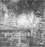
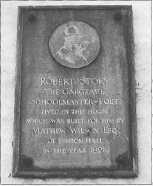
STOREY'S HOUSE
The Wilson's of Eshton Hall built Storey's House and School for Robert Storey in 1828. In 1934 my Grandfather had a plaque placed on the wall of the house in Storey's honour. Nearby are examples of some of the oldest cottages in Gargrave. The return was no longer to a muddy place, but a tarmac car park
John Fox.
Acknowledgements: History of Gargrave, Harry M. Gill Leeds & Liverpool Canal, Mike Clarke.
2 June 2002
Meeting Place Stainforth Car Park
Leader David Johnson
The theme of this walk was lime workings and readers are directed to David's scholarly book recently published by Tempest, on the subject Limestone Industries of the Yorkshire Dales.
7 July 2002
Leader Michael Southworth
Meeting Place Bank End Farm, Lawkland
The walk starts at Bank End Farm., Lawkland and goes across Lawkland Moss to Eldroth, returning across the fields past Lawkland Hall W'ood and Lawkland Hall. It is of interest to reflect that a part of the route - from the Eldroth road down across Lawkland Moss - is likely to have been the route taken every Sunday by the parishioners of Eldroth to attend church in Clapham, until such time as Eldroth Church was built in 1627. Part of the reason given for the building of Eldroth Church was because the people of the hamlet were 'two or three miles distant from the Parish Church and having such waters between them and their Parish Church as many times are not passable, neither on horseback nor foot'!
Here are some items of interest along the way:
1. Lawkland Poor House
The line of cottages, now known as The Cottages, was the site of the Lawkland Poor House.
The exact date of the opening of the Lawkland Poor House is not known, but we do know that it was up and running in April 1823 and closed at the end of 1837. On the 28th April, 1823 there were 14 paupers in residence - four from Lawkland, seven from Horton and three from Austwick.
During the period 1823-1837 some 357 different paupers were in residence for periods ranging from 1 day to several years. Of this total 167 were male and 190 female. During the same period 36 paupers are recorded as having died within its walls. At the height of its occupancy, in 1826, the average nightly occupancy was just over 35 souls.
The closure of the Poor House in 1837 seems to have been brought about by the building of a larger establishment in Settle in 1835.
2. Chapel House
Chapel House is the site of a Roman Catholic Chapel and there was a Franciscan convent adjoining, used as a home for aged and infirm priests.
The Chapel was probably built sometime around 1756 by the Ingleby family of Lawkland Hall and was in use until 1930. It was dedicated to St. Oswald. Prior to the building of the chapel the local Catholics had worshipped, often in secret, at a small chapel in the Hall itself.
The building of the chapel by the Ingleby's coincided with the family's reported conversion to Protestantism.
3. Lawkland Moss
Lawkland Moss (along with Austwick Moss) is a Site of Special Scientific Interest (SSSI) and is of particular interest to botanists and entomologists. Part of the Moss used to be divided into 'dales', which were strips of land with dykes on either side. These dales were rented by local farmers and a hay crop taken from them each summer. At least one local also used his dale for growing potatoes! The last time hay was made on the Moss was in the 1950s.
4. Eldroth Hall
Eldroth Hall was used as a rendezvous for the Society of Friends and from 1662-1712 part of the farmyard was used as a Quaker burial ground. During this period there were 17 burials recorded.
During the second World War a bomb was dropped in the fields nearby. It was believed that the German bomber had lost its way on a raid (perhaps on Liverpool) and decided to target a train before returning home. The train was unscathed but some cattle were killed.
5. Lawkland Hall water source
The source of water supplying Lawkland Hall is from a spring a: Knott Coppy, just south of the Eldroth road. The Hall does also have a mains supply, but they still mainly use the water from this spring.
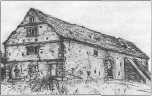
6. Tythe Barn
A very fine barn used to be sited in the field beside Lawkland Hall Wood, but regrettably this building was demolished in 1989 following refusal of planning permission for its conversion into a dwelling. The picture below was painted by Mary Farnell of Clapham in 1988, just before demolition.
Much has been written about Lawkland Hall, but here is a potted version. The house is mediaeval in origin, said to have been built by the Yorke family. Peter Yorke of Middlcsmoor, Co. York married the daughter of Sir William Ingleby of Ripley Castle.
Via this route the Hall came into the ownership of the Ingleby family in about 1572 and remained in their ownership until 1914, although in the latter years the house was occupied by tenants.
In 1914 the house was sold to John Norman Ambler, a woollen manufacturer from Bradford, who in turn sold to my father in 1939, who sold to Richard Bowring in 1957.
The house is now owned by Giles Bowring, the son of Richard.
Footnote: Lawkland Hall garden is open occasionally in aid of charity.
Michael Southworth
Sunday 1 September 2002
Leaders Roy Gudgeon & Ethne Bannister
Meeting Place Coniston Hall Hotel
In November 2001, Mrs Ethne Bannister after delivering a most interesting and informative lecture at Long Preston to the Trust, invited members along to Coniston Cold to see at first
hand the subject of her talk, the building and estate of Coniston Hall.
On a very warm afternoon, over forty members had gathered at the Hotel and Mrs Bannister led us on a most pleasant excursion around the Coniston estate. We stopped briefly at the Ice House, which is now 'listed', before walking across to the Church at Coniston Cold where we inspected the various internal points of interest. Our route then took us across frelds and woodland, until we reached the side of Coniston Lake, and we then walked along the shore-side until we came to Coniston Hall.
The present Coniston Hall was built by Mr and Mrs Bannister close to the site of the old Coniston Hall which had to be demolished because of problems caused by neglect over the past years. We were most fortunate that many items were made available to us including many photographs of the site and building work together with many of the original plans. The afternoon was rounded off with refreshment at the Coniston Hall Hotel, and enjoyed
by all.
RKG
6 October 2002
Leader: Alan Aspden
Meeting place: Car park alongside Church, Kirkby Malham
The walk coincided with the inauguration of the new church bells and the visit of the Archbishop of York to Kirkby Malham.
The route was a circular one of almost five miles around the grassy rolling hills of this picturesque southern Dales village. The walk went south, over Warber Hill, passing through Airton and Calton before following the river north to Hanlith and returning to Kirkby Malham from the east.
The claim to fame of these villages is their Civil War and Cromwellian connections. The party were able to view the plaque outside Calton Hall commemorating General John Lambert, reputedly Cromwell's second-in-command and later to admire the side chapel in Kirkby Malham Church, recently refurbished by the Cromwell Society. Some unusual gravestones were also seen in the
20
churchyard of this 'Cathedral of the Dales'.
When approaching the village on the return journey we were privileged to hear a special ring of the new church bells by the visiting ringers at the Inauguration Service. This was a fitting climax to a lovely Dales afternoon out.
AA
3 November 2002
Leaders Keith and Olwyn Bolger
Meeting place: Settle Swimming Pool car park
FORTY-FIVE YEARS ON
We have recently been reflecting on the changes in our backyard since we came to live here. This walk covered that part of the yard comprising the Ribble Valley floor stretching from Settle bridge to Stainforth bridge, and it afforded a surprising number of examples of change. We tend to pay attention mainly to the way our environmental heritage was built up over the centuries but the last half-century has seen a phenomenal acceleration of change and it was precisely the awareness of rapid change that brought the Trust into being.
The Ribble Way above Settle bridge skirts the football club pitch and the playing fields of the Middle and High Schools. We paused to remember how these well manicured spaces and the buildings of the Middle School and the Swimming Pool have obliterated Bridge End Farm. Behind them the hillside has been devoted to new housing, starring with Yealand Avenue and culminating with Meadow Rise. We turned to look across the river and noted more new housing and also that Brassington's Sawmill is now converted to flats and that the Shed Mill is now a popular commercial and visitor centre. Further along the path there was impressive new development at Langcliffe High Mill, a satellite of the Paper Mill on the Langcliffe Stainforth border, itself enlarged recently.
Globalization of trade has taken away our textile industries and forced ever increasing amalgamation of farm holdings. Advances in transport and communications and the growth of the affluent society have brought an influx of people to buy the surplus farmhouses and convert the barns and more
recently to prompt large-scale conversions and new building. Tourism has flourished and there has been more public funding to build schools and improve roads.
As we wended our way up the riverside (and on the return leg by the higher path back to Stackhouse and home via The Mains) we were grateful that the recent continuous rain had relented to give us a fine, even sunny day. We were also grateful that the affluent society has an environmental conscience so that the river water is cleaner now than for generations. I learnt that a member's husband had designed the fish ladders at Settle weir and the Locks weir and when we reached Stainforth Foss we were thrilled to see so many salmon leaping. We were grateful, too, that in spite of or because of all the changes our backyard is as beautiful and as enjoyable as it was when we first came to know it.
K & O Bolger
1 December 2002
Leaders: Helen and Arthur Lupton
Meeting Place: Greenfoot car park, Settle
We had a beautiful sunny afternoon for a brief tour of Settle, starting from the Rugby Field and then climbing up the Well Steps to Castleberg Lane and to the smithy. There we examined the brand marks on the big doors, burnt by successive blacksmiths as proof of the quality of each new branding iron and evidence against any later complaint of error.
The next port of call was behind the Bungalows, built on the site of Townhead House. Here there are dogs' graves, with affectionate headstones, and the entrance to the tunnel, now walled up, which used to lead under the High Road to the private woodland on the slope behind.
Moving round to the road above the tunnel we met Sally Timmins, a granddaughter of Tot Lord, who had known the house well in her grandfather's time. She spoke of the happy times they had there, of the excitement of having such a grandfather, and described the extent and nature of the big house, the greenhouses and the outlying buildings.
It was a bonus to be allowed (strictly at our own risk) to explore the northern end of the Castleberg plantation where we could also investigate the other end of the tunnel. It is hoped that this area will be opened to the public when the renovation works have been completed and the sadly dilapidated building has been made safe and restored. The view from near the top of the wood is astonishing, and surprisingly different from the one we are familiar with from the flagstaff. We were most grateful to Sally and David Timmins for this opportunity.
After a walk along the road and examination from afar of the new housing going up near the parish church, our route took us down past Barrel Sykes Farm (again with permission) and through the Northfields Estate and on to view the weir and head works which once regulated the flow of water down the leat to Kings Mill. The mill itself delayed the party for some time as we admired the alterations to the building and discussed the housing project now rapidly advancing on the adjacent site.
The object of the walk was now at hand as we headed for Whitebeam Croft and the traditional annual cups of tea and mince pies with our Vice President.
A&HL
7. Lawkland Hall