Michael J. Slater
The two plans made in 1603 and 1619 of disputed boundaries on Ingleborough described in an accompanying article, show names of various features. Most of the names are identifiable with those on modern maps allowing for idiosyncratic spelling and variations but some deserve some comment.
On the plan made by Christofer Saxton in 1603 there are several items of note. Ingleborow beken is placed near Ingleboro ; the beacon is something that has probably disappeared since the present structures are relatively modern. The lordes seate is written twice for places several hundred meters apart; while one of these is probably the identifiable summit of Simon Fell the second is not an obvious physical feature. The area concerned is a peat bog and duplication of the name may simply denote an area not a point. Are we to think of the Lord of the manor or the Lord on High? The word seat might be the Old Norse word saeti meaning seat, referring to a prominent viewpoint, or shieling. Wharffe Mosse and Theves Mosse refer to swampy ground; today these areas are wet in part but show much limestone pavement - has the removal of peat led to exposure of the pavement? Horton Sty is probably so named since sty is Old English for a narrow or steep path - c.f. the German word steigen - to climb. It later became the main coach road called Clapham Lane. Sulber has an ancient settlement and field system - several old words are available to explain the name - sel for hut, selja for willow, sol for sunny. The second syllable ber means hill; 'huts on the hill' seems a reasonable guess. However, sulber could mean silver, referring to glistening limestone. Selside could mean huts at the shieling (saetre), or willow shieling, although other meanings have been proposed. The Brocken Wall lies just south of Sulber Gate where various sections of old walls remain. The three cairns (?) marked on the rough plan (but not on the final copy) in this area appear to be extant. They are probably Bronze Age burial tumuli.
The 1619 plan made by Newby contains other names of interest. It is not obviously a copy of the earlier Saxton plan and does not concern the same dispute. The 4 graines near Trow Gill might be the junction of several paths with Horton Sty at [SD758 716]. The word grane, grain, grein in ME or ON means a branch, division, or a fork in a river valley. At this point on the plan the Horton Sty track seems to end with a four petalled symbol. Very close by is drawn an open rectangle (the symbol is called Hamerton folde elsewhere) labelled Duttons Hull - the word hulu in OE means shelter - and is thought to be an animal shelter usually built by a wall - it appears to be extant. We also see The highe Hull on Moughton which probably has the same meaning; there is a prominent cairn there. Witton Cove derives from ON, a wooded settlement, and probably refers to Sulber Pot with a pre-medieval settlement site nearby. Several other names are less easy to understand, such as The Freckle Hill and Cromok seavy bargh (hill) all on The Felle Close under Simon Fell by the path from Horton to Ingleborough.
The Lords seate is marked with a symbol of a circle surmounted by a cross, like a sceptre, as is also The highe Hull and Cromok heade and might be supposed to be substantial cairns. Just south of what is now The Lord's seat is a symbol which might represent a gate across the boundary line. The Pyke above Hamerton folde is shown as steep triangle on a decorative rounded base. Hamerton folde is shown as an open rectangle next to the Pyke (peak or hill). The area south of Simon Fell now called The Allotment appears to be called Inkenshaw ( ON Inken may mean enclosure, OE sceaga - copse) on the plan and there are early enclosures and hut circles in the area. Combe Nabbe is probably Moughton Nab, near which were old quarries - Comb Quarry and Combs Thorn Quarry.
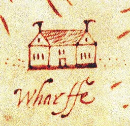
The settlements of Selsyde, Sowthe Houses (now disappeared), Hortonne, Wharffe, Cromok, Clapham and Awstwick are indicated by small drawings of three celled houses but with a central entrance and two cross wings, single and two-storey, reminiscent of a manor house of quality and not of a type often seen in North Craven. Horton Church has a symbol of a rectangle with an orb and cross.
The two plans offer many features of interest to the geographical historian, the walker and the armchair worker!
Acknowledgements
To Jill Sykes for information on place-names. To David S. Johnson for field observations, significant additions and comments.