| JOURNAL 2009 |
| North Craven Heritage Trust |
On another rather damp day the party met at the Thwaite Lane cross-roads north of Austwick to look at aspects of the dale’s geology and history. Looking north from there the group could see several sunken holloways within the fields, each one having been a line of former tracks into the dale. David explained that the present line of Thwaite and Crummack Lanes is relatively modern, with Thwaite Lane given its present straight and walled course after the 1758 enclosure award. The view south from the starting point gave David an excuse to tell the story of how the former Dear Bought farm got its unusual name.
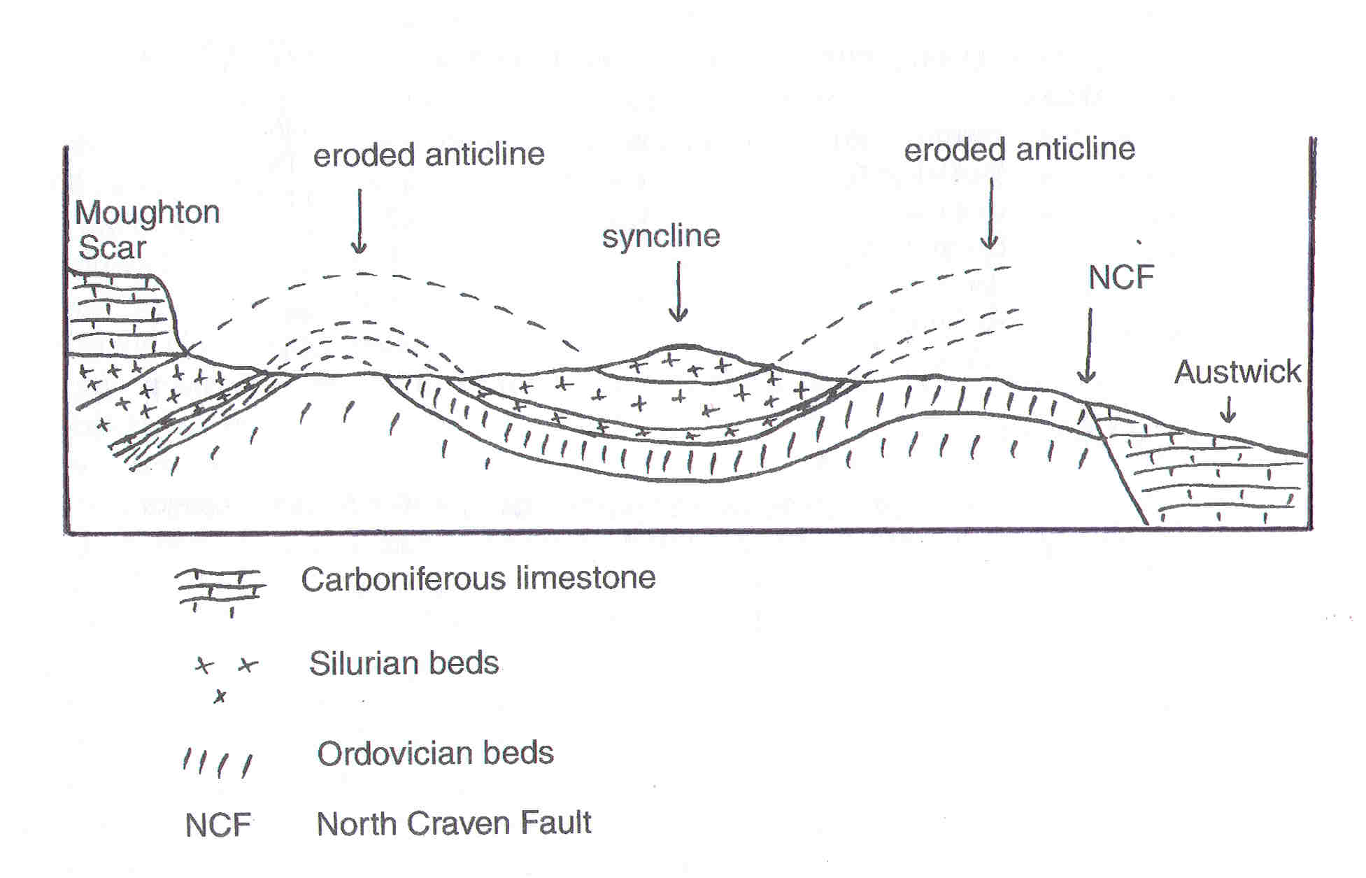
Heading north we crossed an anticline, a geological feature where rocks had been compressed and folded up into a dome. Here, though, millions of years of weathering and erosion have almost completely worn the dome down and only the lowest rock layers have survived. We then crossed a syncline - where rocks were down folded to form a basin - but in Crummack Dale the highest ground is now the syncline and not the anticline (see the diagram). These folds are composed of ancient rocks - from the Silurian period (440 to 416 million years old) on the eastern side of the dale but Ordovician (488 to 440) on the other. Originally the whole area was covered with younger Carboniferous rocks, laid down between 359 and 299 million years ago, but erosion back from the North Craven Fault has removed all the younger rocks except on Scars to the west and Moughton to the east. The Carboniferous rocks are in more or less horizontal beds but the older layers have been folded and tilted to an angle of about 70 degrees. There is a very sharp break between the two sets of rocks at Studrigg Scar, which is free of scree making it easy to see how the younger horizontal limestones sit on the steeply-dipping Silurian beds. This break means that something happened between the Silurian and Carboniferous periods and, in fact, there is a gap of about 50 million years. Breaks in the geological sequence like this are called unconformities and Studrigg Scar is an excellent example.
Before dropping down to Wash Dub we stopped to look over a series of fields alongside the beck, north of Whitestone Lane. This was called Bullet Mire and it was divided up by agreement of the gait holders in 1782 and supposedly improved, though there is little sign this made much difference. Walking up Moughton Lane on the east side of the dale showed clearly how geology is reflected in the walls. Some are made up of resistant Silurian gritstones - these walls still stand to their original height - but further up the lane the walls have crumbled away as they were constructed with soft Silurian siltstones. The wall that clings to the crest of the valley sides is made of limestone. This is an ancient wall shown on maps compiled in 1603 and 1619 (see the Journal 2004).
We headed southwards on the field path across the dale bottom back to Crummack Lane and then took the path to Nappa Scars where there is another unconformity, this time between Ordovician rocks below the path and Carboniferous in the upper scar. Sandwiched between the two is a 1m thick layer of what geologists call conglomerate, a mixture of rock fragments cemented together by deposits of calcium carbonate. We continued across the lower part of Norber with its scatter of glacial erratic boulders, dragged from within the dale by ice, and headed back to Austwick looking in vain for the line of the North Craven Fault that crosses the road just north of Townhead.